Newfield (CDP), New York

Last updated

Newfield, New York
CDP
USA New York location map.svg
Red pog.svg
Newfield, New York
Location within the state of New York
Coordinates: 42°21′43″N76°35′32″W / 42.36194°N 76.59222°W / 42.36194; -76.59222
Country United States
State New York
County Tompkins
Incorporated1895
DissolvedDecember 31, 1927
Area
[1]
  Total1.26 sq mi (3.26 km2)
  Land1.26 sq mi (3.26 km2)
  Water0.00 sq mi (0.00 km2)
Population
 (2020)
  Total725
  Density576.77/sq mi (222.64/km2)
Time zone UTC-5 (Eastern (EST))
  Summer (DST) UTC-4 (EDT)
FIPS code 36-50257

Newfield is a census-designated place (CDP) [2] in Tompkins County, New York, United States. The population was 759 at the 2010 census.

Contents

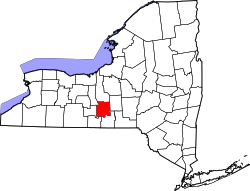
Newfield Hamlet lies near the center of the town of Newfield and is located southwest of Ithaca.

It was incorporated as a village in 1895. On September 21, 1926, local residents voted in favor of dissolution. Final sale and transfer of assets and services to the Town of Newfield took place on March 21, 1927 when the Village of Newfield Board of Trustees held their last meeting. The village officially dissolved on December 31, 1927. [3]

Geography

Newfield Hamlet is located at 42°21′43″N76°35′32″W / 42.36194°N 76.59222°W / 42.36194; -76.59222 (42.361957, -76.592094). [4]

According to the United States Census Bureau, the CDP has a total area of 1.2 square miles (3.1 km2), all land.

New York State Route 13, as Elmira Road, bypasses Newfield Hamlet.

Demographics

Historical population
CensusPop.Note
2020 725
U.S. Decennial Census [5]

As of the census [6] of 2000, there were 647 people, 294 households, and 169 families residing in the CDP. The population density was 518.5 inhabitants per square mile (200.2/km2). There were 314 housing units at an average density of 251.6 per square mile (97.1/km2). The racial makeup of the CDP was 96.60% White, 1.55% African American, 0.31% Native American, 0.46% from other races, and 1.08% from two or more races. Hispanic or Latino of any race were 1.39% of the population.

There were 294 households, out of which 28.2% had children under the age of 18 living with them, 45.6% were married couples living together, 9.2% had a female householder with no husband present, and 42.5% were non-families. 35.7% of all households were made up of individuals, and 16.3% had someone living alone who was 65 years of age or older. The average household size was 2.20 and the average family size was 2.87.

In the CDP, the population was spread out, with 22.9% under the age of 18, 7.1% from 18 to 24, 30.3% from 25 to 44, 25.0% from 45 to 64, and 14.7% who were 65 years of age or older. The median age was 40 years. For every 100 females, there were 89.7 males. For every 100 females age 18 and over, there were 81.5 males.

The median income for a household in the CDP was $43,056, and the median income for a family was $56,522. Males had a median income of $26,875 versus $35,236 for females. The per capita income for the CDP was $18,461. About 4.1% of families and 7.4% of the population were below the poverty line, including 5.3% of those under age 18 and 7.7% of those age 65 or over.

Related Research Articles

<span class="mw-page-title-main">West Perrine, Florida</span> Census-designated place in Florida, United States

West Perrine is a census-designated place (CDP) in Miami-Dade County, Florida, United States. Prior to the 2000 census it was part of Perrine. The other part of Perrine became the East Perrine CDP for the 2000 census and is now part of the incorporated Village of Palmetto Bay. West Perrine is still an unincorporated area, although some residents have discussed the possibility of incorporating Perrine. The population was 10,602 at the 2020 census, up from 9,460 in 2010. The name derives from a land grant issued to the heirs of Henry Perrine, an agriculturist.

<span class="mw-page-title-main">North Terre Haute, Indiana</span> Census-designated place in Indiana, United States

North Terre Haute is a census-designated place (CDP) in Otter Creek Township, Vigo County, in the U.S. state of Indiana. The population was 4,305 at the 2010 census. It is part of the Terre Haute Metropolitan Statistical Area.

Munsons Corners is a hamlet and census-designated place (CDP) in Cortland County, New York, United States. The population was 2,728 at the 2010 census.

<span class="mw-page-title-main">Angola on the Lake, New York</span> Census-designated place in New York, United States

Angola on the Lake is a hamlet and census-designated place (CDP) in Erie County, New York, United States. The population was 1,675 at the 2010 census. It is part of the Buffalo–Niagara Falls Metropolitan Statistical Area.

<span class="mw-page-title-main">Lake Erie Beach, New York</span> Census-designated place in New York, United States

Lake Erie Beach is a hamlet and census-designated place (CDP) in the town of Evans, Erie County, New York, United States. The population was 3,872 at the 2010 census. It is part of the Buffalo–Niagara Falls Metropolitan Statistical Area.

Adams Center is a hamlet and census-designated place (CDP) in the town of Adams in Jefferson County, New York, United States. The population was 1,492 during the 2020 decennial census.

<span class="mw-page-title-main">Mattydale, New York</span> Census-designated place in New York, United States

Mattydale is a hamlet in Onondaga County, New York, United States. The population was 6,446 at the 2010 census.

<span class="mw-page-title-main">Nedrow, New York</span> Census-designated place in New York, United States

Nedrow is a hamlet located in the town of Onondaga in Onondaga County, New York, United States. The population was 2,244 at the 2010 census. It is a suburb of Syracuse, whose southern border it adjoins.

<span class="mw-page-title-main">Village Green, New York</span> Census-designated place in New York, United States

Village Green is a hamlet in Onondaga County, New York, United States. The population was 3,891 at the 2010 census.

East Ithaca is a suburban community in Tompkins County, New York, United States. The population was 2,231 at the 2010 census.

Enfield is a town in Tompkins County, New York, United States. The population was 3,401 at the 2020 census.

<span class="mw-page-title-main">Forest Home, New York</span> CDP in New York, United States

Forest Home is a census-designated place (CDP) in Tompkins County, New York, United States. The population was 572 at the 2010 census.

Northeast Ithaca is a census-designated place (CDP) in Ithaca (town), New York in Tompkins County, New York, United States. The population was 2,655 at the 2000 census.

Northwest Ithaca is a census-designated place (CDP) in Tompkins County, New York, United States. The population was 1,115 at the 2000 census.

<span class="mw-page-title-main">South Hill, New York</span> CDP in New York, United States

South Hill is a census-designated place (CDP) in Tompkins County, New York, United States. The population was 7,245 at the 2020 census.

<span class="mw-page-title-main">Rifton, New York</span> CDP in New York, United States

Rifton is a hamlet in Ulster County, New York, United States. The population was 481 at the 2020 census.

<span class="mw-page-title-main">Saugerties South, New York</span> CDP in New York, United States

Saugerties South is a hamlet in Ulster County, New York, United States. The population was 2,442 at the 2020 census.

<span class="mw-page-title-main">West Hurley, New York</span> CDP in New York, United States

West Hurley is a hamlet in Ulster County, New York, United States. The population was 1,917 at the 2020 census.

Big Flats is an unincorporated community and census-designated place (CDP) within the town of Big Flats in Chemung County, New York, United States. The population of the CDP was 5,277 at the 2010 census, out of a total population in the town of 7,595.

<span class="mw-page-title-main">Newfields (CDP), New Hampshire</span> Census-designated place in New Hampshire, United States

Newfields is a census-designated place (CDP) and the main village within the town of Newfields, Rockingham County, New Hampshire, United States. The population of the CDP was 378 at the 2020 census, out of 1,769 in the entire town.

References

  1. "ArcGIS REST Services Directory". United States Census Bureau. Retrieved September 20, 2022.
  2. "State of New York Census Designated Places - Current/BAS20 - Data as of January 1, 2019". tigerweb.geo.census.gov. Retrieved February 25, 2020.
  3. Ithaca.com, Vote Next in Candor Village Dissolution Process, November 4, 2009, Retrieved Jun. 14, 2015.
  4. "US Gazetteer files: 2010, 2000, and 1990". United States Census Bureau. February 12, 2011. Retrieved April 23, 2011.
  5. "Census of Population and Housing". Census.gov. Retrieved June 4, 2016.
  6. "U.S. Census website". United States Census Bureau . Retrieved January 31, 2008.