Dryden (village), New York

Last updated

Dryden, New York
Dryden Historic District Jan 10.jpg
Dryden Historic District
USA New York location map.svg
Red pog.svg
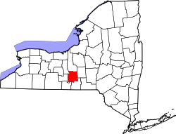
Dryden, New York
Location within the state of New York
Coordinates: 42°29′21″N76°17′59″W / 42.48917°N 76.29972°W / 42.48917; -76.29972
Country United States
State New York
County Tompkins
Settled1797 (1797)
IncorporatedJuly 7, 1857 (1857-07-07)
Named after John Dryden
Government
  Mayor (2 year term, election in March of odd years)Michael Murphy
  Trustees (2 year term, election in March of odd years)Tom Sinclair, Deputy Mayor; Jason Dickinson; Dan Wakeman; Clay Converse
Area
[1]
  Total
1.77 sq mi (4.58 km2)
  Land1.76 sq mi (4.55 km2)
  Water0.01 sq mi (0.04 km2)
Elevation
1,089 ft (332 m)
Population
 (2020)
  Total
1,887
  Density1,074.60/sq mi (414.83/km2)
Time zone UTC-5 (Eastern (EST))
  Summer (DST) UTC-4 (EDT)
ZIP code
13053
Area code 607
FIPS code 36-20951
GNIS feature ID0948704
Website www.dryden-ny.org

Dryden is a village in Tompkins County, New York, United States. The population was 1,887 at the 2020 census. [2] The village is in the town of Dryden, east of Ithaca. It is near the border of Cortland County.

Contents

History

The village is in the former Central New York Military Tract.

The first settler in the town located on the site of the future village in 1797.

The village of Dryden was incorporated in 1857.

The Dryden Historic District, Luther Clarke House, Jennings-Marvin House, Lacy-Van Vleet House, Methodist Episcopal Church, Rockwell House, Southworth House, and Southworth Library are listed on the National Register of Historic Places. [3]

Cueball Carmichael

Christoper Jackson

Professional Wrestler Trainer Promoter

Geography

Dryden is located at 42°29′21″N76°17′58″W / 42.48917°N 76.29944°W / 42.48917; -76.29944 (42.489188, -76.299589). [4]

According to the United States Census Bureau, the village has a total area of 1.7 square miles (4.3 km2).None of the area is covered with water.

New York State Route 13 intersects New York State Route 38 in the village.

Demographics

Historical population
CensusPop.Note
1870 672
1880 77915.9%
1890 663−14.9%
1900 6995.4%
1910 7091.4%
1920 707−0.3%
1930 666−5.8%
1940 74712.2%
1950 97630.7%
1960 1,26329.4%
1970 1,49018.0%
1980 1,76118.2%
1990 1,9088.3%
2000 1,832−4.0%
2010 1,8903.2%
2020 1,887−0.2%
U.S. Decennial Census [5]

As of the census [6] of 2000, there were 1,832 people, 772 households, and 469 families residing in the village. The population density was 1,104.9 inhabitants per square mile (426.6/km2). There were 811 housing units at an average density of 489.1 per square mile (188.8/km2). The racial makeup of the village was 96.18% White, 1.26% Black or African American, 0.33% Native American, 0.27% Asian, 0.49% from other races, and 1.47% from two or more races. Hispanic or Latino of any race were 1.36% of the population.

There were 772 households, out of which 30.8% had children under the age of 18 living with them, 49.2% were married couples living together, 7.8% had a female householder with no husband present, and 39.2% were non-families. 33.4% of all households were made up of individuals, and 10.9% had someone living alone who was 65 years of age or older. The average household size was 2.37 and the average family size was 3.06.

In the village, the population was spread out, with 26.4% under the age of 18, 8.9% from 18 to 24, 28.9% from 25 to 44, 24.3% from 45 to 64, and 11.5% who were 65 years of age or older. The median age was 37 years. For every 100 females, there were 98.1 males. For every 100 females age 18 and over, there were 95.1 males.

The median income for a household in the village was $43,977, and the median income for a family was $54,489. Males had a median income of $38,897 versus $26,809 for females. The per capita income for the village was $20,613. About 5.1% of families and 9.9% of the population were below the poverty line, including 14.1% of those under age 18 and 4.7% of those age 65 or over.

Education

Dryden Village is in the Dryden Central School District. [7] The zoned comprehensive high school is Dryden High School.

References

  1. "ArcGIS REST Services Directory". United States Census Bureau. Retrieved September 20, 2022.
  2. "Explore Census Data". data.census.gov. Retrieved June 5, 2024.
  3. "National Register Information System". National Register of Historic Places . National Park Service. March 13, 2009.
  4. "US Gazetteer files: 2010, 2000, and 1990". United States Census Bureau. February 12, 2011. Retrieved April 23, 2011.
  5. "Census of Population and Housing". Census.gov. Retrieved June 4, 2015.
  6. "U.S. Census website". United States Census Bureau . Retrieved January 31, 2008.
  7. "2020 CENSUS - SCHOOL DISTRICT REFERENCE MAP: Tompkins County, NY" (PDF). U.S. Census Bureau . Retrieved December 23, 2024. - Text list