South Hill, New York

Last updated

South Hill, New York
CDP
Park Center for Business and Sustainable Enterprise, Ithaca College.jpg
Park Center, a building in the Ithaca College campus
USA New York location map.svg
Red pog.svg
South Hill, New York
Location within the state of New York
Coordinates: 42°24′42″N76°29′26″W / 42.41167°N 76.49056°W / 42.41167; -76.49056
Country United States
State New York
County Tompkins
Area
[1]
  Total5.99 sq mi (15.52 km2)
  Land5.90 sq mi (15.27 km2)
  Water0.10 sq mi (0.25 km2)
Elevation
778 ft (237 m)
Population
 (2020)
  Total7,245
  Density1,228.80/sq mi (474.44/km2)
Time zone UTC-5 (Eastern (EST))
  Summer (DST) UTC-4 (EDT)
FIPS code 36-69199
GNIS feature ID0965771

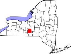
South Hill is a census-designated place (CDP) in Tompkins County, New York, United States. The population was 7,245 at the 2020 census.

Contents

The South Hill CDP is located within the town of Ithaca. It is located near the south end of Cayuga Lake. The name South Hill is shared with a contiguous area within the City of Ithaca.

Ithaca College is located in the South Hill CDP.

Geography

South Hill is located at 42°24′42″N76°29′26″W / 42.41167°N 76.49056°W / 42.41167; -76.49056 (42.411598, -76.490605). [2]

According to the United States Census Bureau, the CDP has a total area of 6.0 square miles (16 km2), of which, 5.9 square miles (15 km2) of it is land and 0.1 square miles (0.26 km2) of it (1.50%) is water.

Demographics

Historical population
CensusPop.Note
2000 6,003
2010 6,67311.2%
2020 7,2458.6%
U.S. Decennial Census [3]

As of the census [4] of 2000, there were 6,003 people, 1,073 households, and 491 families residing in the CDP. The population density was 1,015.7 inhabitants per square mile (392.2/km2). There were 1,139 housing units at an average density of 192.7 per square mile (74.4/km2). The racial makeup of the CDP was 91.64% White, 2.42% African American, 0.13% Native American, 1.77% Asian, 0.03% Pacific Islander, 1.78% from other races, and 2.23% from two or more races. Hispanic or Latino of any race were 2.77% of the population.

There were 1,073 households, out of which 22.6% had children under the age of 18 living with them, 37.9% were married couples living together, 5.0% had a female householder with no husband present, and 54.2% were non-families. 31.6% of all households were made up of individuals, and 15.9% had someone living alone who was 65 years of age or older. The average household size was 2.44 and the average family size was 2.90.

In the CDP, the population was spread out, with 7.1% under the age of 18, 69.3% from 18 to 24, 9.2% from 25 to 44, 8.6% from 45 to 64, and 5.7% who were 65 years of age or older. The median age was 20 years. For every 100 females, there were 83.7 males. For every 100 females age 18 and over, there were 82.3 males.

The median income for a household in the CDP was $43,868, and the median income for a family was $66,364. Males had a median income of $44,500 versus $28,491 for females. The per capita income for the CDP was $11,495. None of the families and 23.1% of the population were living below the poverty line, including no under eighteens and 5.6% of those over 64.

Related Research Articles

<span class="mw-page-title-main">Cooper Landing, Alaska</span> Census-designated place in Alaska, United States

Cooper Landing is a census-designated place (CDP) in Kenai Peninsula Borough, Alaska, United States, about 100 miles (160 km) south of Anchorage, at the outlet of Kenai Lake into the Kenai River. The town was first settled in the 19th century by gold and mineral prospectors, and has become a popular summer tourist destination thanks to its scenic location and proximity to the salmon fishery of the Kenai River and Russian River. As of the 2010 census, the population in Cooper Landing was 289, down from 369 in 2000.

<span class="mw-page-title-main">South Oroville, California</span> Census-designated place in California, United States

South Oroville is a census-designated place (CDP) in Butte County, California, United States. The population was 5,742 at the 2010 census, down from 7,695 at the 2000 census.

<span class="mw-page-title-main">Brookridge, Florida</span> Census-designated place in Florida, United States

Brookridge is a census-designated place (CDP) in Hernando County, Florida, United States. The population was 4,420 at the 2010 census, up from 3,279 at the 2000 census.

<span class="mw-page-title-main">Pleasant Hills, Maryland</span> Census-designated place in Maryland, United States

Pleasant Hills is a census-designated place (CDP) in Harford County, Maryland, United States. The population was 3,379 at the 2010 census, up from 2,851 in 2000. There is no post office with the designation "Pleasant Hills"; most of the residents have either Fallston or Kingsville addresses and consider themselves as belonging to those communities.

<span class="mw-page-title-main">Walthill, Nebraska</span> Village in Thurston County, Nebraska, United States

Walthill is a village in Thurston County, Nebraska, United States, within the Omaha Reservation. The population was 780 at the 2010 census.

Melrose Park is a suburban community and census-designated place (CDP) in Cayuga County, New York, United States. The population was 2,294 at the 2010 census. It is a suburb of Auburn, located south of the city in the town of Owasco.

Munsons Corners is a hamlet and census-designated place (CDP) in Cortland County, New York, United States. The population was 2,728 at the 2010 census.

<span class="mw-page-title-main">Brewster Hill, New York</span> Census-designated place in New York, United States

Brewster Hill is a hamlet located in the town of Southeast in Putnam County, New York, United States. As of the 2010 census, the population was 2,089.

East Ithaca is a suburban community in Tompkins County, New York, United States. The population was 2,231 at the 2010 census.

<span class="mw-page-title-main">Forest Home, New York</span> CDP in New York, United States

Forest Home is a census-designated place (CDP) in Tompkins County, New York, United States. The population was 572 at the 2010 census.

Newfield is a census-designated place (CDP) in Tompkins County, New York, United States. The population was 759 at the 2010 census.

Northeast Ithaca is a census-designated place (CDP) in Ithaca (town), New York in Tompkins County, New York, United States. The population was 2,655 at the 2000 census.

Northwest Ithaca is a census-designated place (CDP) in Tompkins County, New York, United States. The population was 1,115 at the 2000 census.

<span class="mw-page-title-main">Saugerties South, New York</span> CDP in New York, United States

Saugerties South is a hamlet in Ulster County, New York, United States. The population was 2,442 at the 2020 census.

Flying Hills is a census-designated place (CDP) in Cumru Township, Berks County, Pennsylvania. The population was 2,568 as of the 2010 census.

<span class="mw-page-title-main">Iola, Pennsylvania</span> Census-designated place in Pennsylvania, United States

Iola is a census-designated place in Columbia County, Pennsylvania, United States. It is part of Northeastern Pennsylvania. The population was 144 at the 2010 census. It is part of the Bloomsburg-Berwick micropolitan area.

<span class="mw-page-title-main">Numidia, Pennsylvania</span> Census-designated place in Pennsylvania, United States

Numidia is a census-designated place (CDP) in Columbia County, Pennsylvania, United States. It is part of Northeastern Pennsylvania. The population was 244 at the 2010 census. It is part of the Bloomsburg-Berwick metropolitan area.

<span class="mw-page-title-main">Rupert, Pennsylvania</span> Census-designated place in Pennsylvania, United States

Rupert is a census-designated place (CDP) in Columbia County, Pennsylvania, United States. It is part of Northeastern Pennsylvania. The population was 183 at the 2010 census. It is part of the Bloomsburg-Berwick micropolitan area.

<span class="mw-page-title-main">Slabtown, Pennsylvania</span> Census-designated place in Pennsylvania, United States

Slabtown is a census-designated place in Columbia County, Pennsylvania, United States. It is part of Northeastern Pennsylvania. The population was 156 at the 2010 census. It is part of the Bloomsburg-Berwick micropolitan area.

Timber Hills is an unincorporated community and census-designated place (CDP) in Lebanon County, Pennsylvania, United States. The population was 360 at the 2010 census.

References

  1. "ArcGIS REST Services Directory". United States Census Bureau. Retrieved September 20, 2022.
  2. "US Gazetteer files: 2010, 2000, and 1990". United States Census Bureau. February 12, 2011. Retrieved April 23, 2011.
  3. "Census of Population and Housing". Census.gov. Retrieved June 4, 2016.
  4. "U.S. Census website". United States Census Bureau . Retrieved January 31, 2008.