Forest Home, New York

Last updated

Forest Home, New York
CDP
Forest Home Chapel with Trees.jpg
Forest Home Chapel
USA New York location map.svg
Red pog.svg
Forest Home, New York
Location within the state of New York
Coordinates: 42°27′11″N76°28′17″W / 42.45306°N 76.47139°W / 42.45306; -76.47139
Country United States
State New York
County Tompkins
Area
[1]
  Total0.24 sq mi (0.63 km2)
  Land0.23 sq mi (0.58 km2)
  Water0.02 sq mi (0.05 km2)
Elevation
922 ft (281 m)
Population
 (2020)
  Total1,168
  Density5,191.11/sq mi (2,004.07/km2)
Time zone UTC-5 (Eastern (EST))
  Summer (DST) UTC-4 (EDT)
FIPS code 36-26561
GNIS feature ID0950403

Forest Home is a census-designated place (CDP) in the town of Ithaca, New York, United States. The population was 572 at the 2010 census. It is located immediately east of the Cornell University campus.

Contents

History

The first European settlers, Joseph and Martha Sydney, founded a mill on Fall Creek in 1794, and other grist and sawmills were soon constructed. During this time the community was called Free Hollow, which changed to Forest Home in 1876. [2] Two historic steel truss bridges, both still used today, were finished in the early twentieth century. The last operating mill in the village was closed in 1926. [2] Today, Forest Home is a small residential community nearly surrounded by the Cornell Botanic Gardens.

The Forest Home Historic District was listed on the National Register of Historic Places in 1998. [3]

Geography

Forest Home is located at 42°27′11″N76°28′17″W / 42.45306°N 76.47139°W / 42.45306; -76.47139 (42.453158, -76.471473). [4]

According to the United States Census Bureau, the CDP has a total area of 0.3 square miles (0.78 km2), of which, 0.3 square miles (0.78 km2) of it is land and 3.70% is water.

The community is located near the south end of Cayuga Lake.

Demographics

Historical population
CensusPop.Note
2020 1,168
U.S. Decennial Census [5]

As of the census [6] of 2000, there were 941 people, 424 households, and 245 families residing in the CDP. The population density was 3,598.4 inhabitants per square mile (1,389.4/km2). There were 446 housing units at an average density of 1,705.5 per square mile (658.5/km2). The racial makeup of the CDP was 50.58% White, 5.10% African American, 0.32% Native American, 38.36% Asian, 2.55% from other races, and 3.08% from two or more races. Hispanic or Latino of any race were 9.56% of the population.

There were 424 households, out of which 31.4% had children under the age of 18 living with them, 51.9% were married couples living together, 5.2% had a female householder with no husband present, and 42.0% were non-families. 25.5% of all households were made up of individuals, and 1.4% had someone living alone who was 65 years of age or older. The average household size was 2.22 and the average family size was 2.76.

In the CDP, the population was spread out, with 20.9% under the age of 18, 9.0% from 18 to 24, 58.0% from 25 to 44, 7.3% from 45 to 64, and 4.7% who were 65 years of age or older. The median age was 29 years. For every 100 females, there were 97.3 males. For every 100 females age 18 and over, there were 97.3 males.

The median income for a household in the CDP was $23,345, and the median income for a family was $30,759. Males had a median income of $23,092 versus $26,316 for females. The per capita income for the CDP was $17,918. About 23.3% of families and 22.0% of the population were below the poverty line, including 19.0% of those under age 18 and 25.9% of those age 65 or over.

Related Research Articles

Forest Lake is an unincorporated community and census-designated place (CDP) in Ela Township of Lake County, Illinois, United States. It is about 35 miles (56 km) northwest of downtown Chicago. Per the 2020 census, the population was 1,784. The community was founded in 1935 as a vacation community for Chicago residents.

<span class="mw-page-title-main">Hillsmere Shores, Maryland</span> Former census-designated place in Maryland, United States

Hillsmere Shores was a census-designated place (CDP) in Anne Arundel County, Maryland, United States. It is a suburb of Annapolis. The population was 2,977 at the 2000 census. It was included in the Annapolis Neck CDP at the 2010 census. Built in phases, beginning in 1960, the community has been home to The Key School, a non-sectarian private school, since the 1960s.

<span class="mw-page-title-main">Perryman, Maryland</span> Census-designated place in Maryland, United States

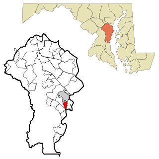
Perryman is an unincorporated community and census-designated place (CDP) in Harford County, Maryland, United States. The population was 2,342 at the 2010 census.

<span class="mw-page-title-main">Kingstown, Maryland</span> CDP in Maryland, United States

Kingstown is a census-designated place (CDP) in Queen Anne's County, Maryland, United States. The population was 1,644 at the 2000 census.

Melrose Park is a suburban community and census-designated place (CDP) in Cayuga County, New York, United States. The population was 2,294 at the 2010 census. It is a suburb of Auburn, located south of the city in the town of Owasco.

Cortland West is a census-designated place and region in Cortland County, New York, United States. The population was 1,356 at the 2010 census.

East Ithaca is a suburban community in Tompkins County, New York, United States. The population was 2,231 at the 2010 census.

Newfield is a census-designated place (CDP) in Tompkins County, New York, United States. The population was 759 at the 2010 census.

Northeast Ithaca is a census-designated place (CDP) in Ithaca (town), New York in Tompkins County, New York, United States. The population was 2,655 at the 2000 census.

Northwest Ithaca is a census-designated place (CDP) in Tompkins County, New York, United States. The population was 1,115 at the 2000 census.

<span class="mw-page-title-main">South Hill, New York</span> CDP in New York, United States

South Hill is a census-designated place (CDP) in Tompkins County, New York, United States. The population was 7,245 at the 2020 census.

<span class="mw-page-title-main">Pine Hollow, Oregon</span> Unincorporated community in the state of Oregon, United States

Pine Hollow is a census-designated place (CDP) and unincorporated community in Wasco County, Oregon, United States. It surrounds Pine Hollow Reservoir. The CDP population was 424 at the 2000 census.

<span class="mw-page-title-main">Jerseytown, Pennsylvania</span> Census-designated place in Pennsylvania, United States

Jerseytown is a census-designated place (CDP) that is located in Madison Township, Columbia County, Pennsylvania, United States. It is part of Northeastern Pennsylvania and of the Bloomsburg-Berwick micropolitan area.

<span class="mw-page-title-main">Lightstreet, Pennsylvania</span> Census-designated place in Pennsylvania, United States

Lightstreet is a census-designated place (CDP) in Columbia County, Pennsylvania, United States. It is part of Northeastern Pennsylvania. The population was 1,093 at the 2010 census. It is part of the Bloomsburg-Berwick micropolitan area. The CDP is named after a street in Baltimore.

<span class="mw-page-title-main">Rupert, Pennsylvania</span> Census-designated place in Pennsylvania, United States

Rupert is a census-designated place (CDP) in Columbia County, Pennsylvania, United States. It is part of Northeastern Pennsylvania. The population was 183 at the 2010 census. It is part of the Bloomsburg-Berwick micropolitan area.

<span class="mw-page-title-main">Slabtown, Pennsylvania</span> Census-designated place in Pennsylvania, United States

Slabtown is a census-designated place in Columbia County, Pennsylvania, United States. It is part of Northeastern Pennsylvania. The population was 156 at the 2010 census. It is part of the Bloomsburg-Berwick micropolitan area.

<span class="mw-page-title-main">Rouseville, Pennsylvania</span> Borough in Pennsylvania, United States

Rouseville is a borough in Venango County, Pennsylvania, United States. The population was 456 at the 2020 census.

<span class="mw-page-title-main">Indian Hills, Texas</span> Census-designated place in Texas

Indian Hills is a census-designated place (CDP) in Hidalgo County, Texas, United States. At the 2010 United States Census, the population was 2,591. It is part of the McAllen–Edinburg–Mission Metropolitan Statistical Area.

<span class="mw-page-title-main">Gloucester Point, Virginia</span> Census-designated place in Virginia, United States

Gloucester Point is a census-designated place (CDP) in Gloucester County, Virginia, United States. The population was 9,402 at the 2010 census. It is home to the College of William & Mary's Virginia Institute of Marine Science, a graduate school for the study of oceanography.

<span class="mw-page-title-main">Satsop, Washington</span> Census-designated place in Washington, United States

Satsop is a census-designated place (CDP) in Grays Harbor County, Washington, United States. The population was 675 at the 2010 census, up from 619 at the 2000 census.

References

  1. "ArcGIS REST Services Directory". United States Census Bureau. Retrieved September 20, 2022.
  2. 1 2 Dieckmann, Jane (1998). The towns of Tompkins County : from Podunk to the Magnetic Springs. DeWitt Historical Society of Tompkins County. ISBN   0942690397.
  3. "National Register Information System". National Register of Historic Places . National Park Service. March 13, 2009.
  4. "US Gazetteer files: 2010, 2000, and 1990". United States Census Bureau. February 12, 2011. Retrieved April 23, 2011.
  5. "Census of Population and Housing". Census.gov. Retrieved June 4, 2016.
  6. "U.S. Census website". United States Census Bureau . Retrieved January 31, 2008.