Trumansburg, New York

Last updated

Trumansburg, New York
Trumansburg New York Main Street.jpg
Trumansburg's Main Street
USA New York location map.svg
Red pog.svg
Trumansburg, New York
Location in the state of New York
Coordinates: 42°32′26″N76°39′36″W / 42.54056°N 76.66000°W / 42.54056; -76.66000
Country United States
State New York
County Tompkins
Settled1793 (1793)
Incorporated1872 (1872)
Named for Early settler
Area
[1]
  Total1.39 sq mi (3.60 km2)
  Land1.39 sq mi (3.59 km2)
  Water0.00 sq mi (0.01 km2)
Elevation
965 ft (294 m)
Population
 (2020)
  Total1,714
  Density1,235.76/sq mi (477.06/km2)
Time zone UTC-5 (Eastern (EST))
  Summer (DST) UTC-4 (EDT)
ZIP code
14886
Area code 607
FIPS code 36-75506
GNIS feature ID0974069
Website www.trumansburg-ny.gov

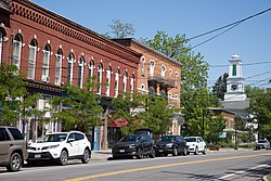
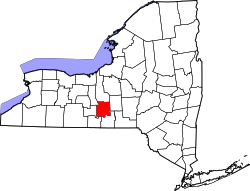
Trumansburg is a village in Tompkins County, New York, United States. The population was 1,797 at the 2010 census. The name incorporates a misspelling of the surname of the founder, Abner Treman. The Tremans spelled their surname several different ways; "Truman," however, was not one of them. The village's application for a post office established the present spelling. The Village of Trumansburg is located within the Town of Ulysses and is northwest of Ithaca, New York.

Contents

History

Abner Treman historic marker Abner Treman historic marker.jpg
Abner Treman historic marker

The village was incorporated in 1872, in the former Central New York Military Tract. The village was originally named "Tremaine's Village", after an early settler, Abner Tremaine (Tremain, Treman), who was granted the land for his service in the American Revolutionary War. The village was built around a cascade on the creek that provided power for grain mills. [ citation needed ]

In the 19th century Trumansburg was dominated by Col. Hermon Camp, an officer in the War of 1812 who settled in what was to become the village. For many years he was the local postmaster, and founded a bank, now the Tompkins Trust Company, the largest bank in the county. His imposing and elegant Greek Revival style house remains the largest in the village. The Hermon Camp House was listed on the National Register of Historic Places in 1973. [2] Also listed on the National Register of Historic Places are the First Presbyterian Church of Ulysses, William Austin House, Indian Fort Road Site, and Second Baptist Society of Ulysses. [2]

In the latter half of the 20th century, as the quality of the road between Trumansburg and Ithaca improved and "country living" became more fashionable, the village became home to many faculty and staff at nearby Cornell University and Ithaca College, as well as many musicians. [3] Between 1961 and 1970, Robert Moog built electronic music equipment including Theremins and his famous synthesizers in a downtown storefront. [4]

From 2004 to 2007, the mayor was John R. Levine, the original author of The Internet for Dummies.

The life of the village

Trumansburg
Trumansburg New York Village Offices.jpg
Village offices
Taughannock Falls Ithaca.jpg
Taughannock Falls
Trumansburg United Methodist Church, New York.jpg
United Methodist Church
Ulysses Philomathic Library, Trumansburg New York.jpg
Ulysses Philomathic Library

Trumansburg was a milltown and commercial center for the agricultural community from its inception until the Second World War. Since the late 1940s it has become a combination of a bedroom suburb for Ithaca and a modest tourist destination, with restaurants, and antique stores. Since 1991, the Finger Lakes GrassRoots Festival of Music and Dance has taken place each July at the village fairgrounds and is hosted by nationally popular Trumansburg-based band Donna the Buffalo. The village is also located along the Cayuga Wine Trail and is close to Taughannock Falls.

Other cultural resources include the Ulysses Philomathic Library, a member of the Finger Lakes Library System, the Trumansburg Conservatory of Fine Arts, which offers concerts and music lessons, the Ulysses Historical Society Museum, with collections of local historical material, and the Trumansburg Central School District Foundation, which provides financial support for local educational programs.

Baptist, Catholic, Episcopalian, Methodist, and Presbyterian churches are located within the village, with a Baptist church and a meetinghouse of the LDS Church located just outside the village limits.

The Trumansburg Central School District consists of the Elementary School, Russel I. Doig Middle School, and Charles O. Dickerson High School, all of which share a campus at 100 Whig Street. School and local athletic teams use the nickname the Blue Raiders.

Geography

Trumansburg is located at 42°32′26″N76°39′36″W / 42.54056°N 76.66000°W / 42.54056; -76.66000 (42.540447, -76.660121). [5] According to the United States Census Bureau, the village has a total area of 1.2 square miles (3.1 km2), of which, 1.2 square miles (3.1 km2) of it is land and 0.83% is water. The village is located on the Trumansburg Creek (also known as Frontenac Creek) which arises on the ridge west of the village and empties into Cayuga Lake at Frontenac Point. Trumansburg is in the northern part of Tompkins County with its northern boundary bordering Seneca County. It is approximately 12 miles north of Ithaca, New York on the west side of Cayuga Lake. The scenic Taughannock Falls State Park, featuring one of the highest waterfalls east of the Rocky Mountains, is located just southeast of the village at the edge of Cayuga Lake.

Climate

Trumansburg has cold, snowy winters and enjoys warm, pleasant summers. The average annual temperature is 48 °F (9 °C), and the average annual precipitation is 36 inches (910 mm).

Climate data for Trumansburg, New York
MonthJanFebMarAprMayJunJulAugSepOctNovDecYear
Mean daily maximum °F (°C)32
(0)
35
(2)
42
(6)
56
(13)
68
(20)
77
(25)
81
(27)
80
(27)
73
(23)
60
(16)
48
(9)
37
(3)
57
(14)
Mean daily minimum °F (°C)17
(−8)
18
(−8)
25
(−4)
37
(3)
47
(8)
57
(14)
61
(16)
59
(15)
52
(11)
42
(6)
34
(1)
24
(−4)
39
(4)
Average precipitation inches (mm)1.91
(49)
1.87
(47)
2.52
(64)
3.26
(83)
3.16
(80)
3.76
(96)
3.52
(89)
3.16
(80)
4.01
(102)
3.42
(87)
3.22
(82)
2.42
(61)
36.23
(920)
Source: [6]

Transportation

Trumansburg is bisected by NY Route 96, a state highway, enlarged and re-routed in 1961, that runs north to Waterloo and south to Ithaca. Tompkins Consolidated Area Transit (TCAT) (Route 21) provides local bus service to Ithaca with connections to long-distance bus and air service there.

In the 19th century, Trumansburg had a port at Frontenac Point, at the mouth of the Trumansburg Creek on Cayuga Lake. The lake is connected at its north end to the Erie Canal via the Cayuga-Seneca Canal. The docks, warehouses and hotels that made up the port have long since been torn down or have burned. Only scattered pilings remain, and the site is now a camp owned by the local Boy Scout council.

The Lehigh Valley Railroad ran through Trumansburg between 13 September 1873 and October 1962, when the portion south to Ithaca was abandoned and most of the easements sold to the New York Gas & Electric Company (NYSEG). The portion north to Geneva was abandoned in 1967. In the last 15 years the state park system has bought back much of the right-of-way and is in the process of constructing a biking and hiking trail along the portion south to Ithaca. It is called the Black Diamond Trail, after the Lehigh Valley's premier passenger train that ran between New York City and Buffalo along the line (although not stopping in Trumansburg). [ citation needed ]

Demographics

Historical population
CensusPop.Note
1870 1,246
1880 1,37610.4%
1890 1,211−12.0%
1900 1,2251.2%
1910 1,188−3.0%
1920 1,011−14.9%
1930 1,0776.5%
1940 1,1304.9%
1950 1,47930.9%
1960 1,76819.5%
1970 1,8032.0%
1980 1,722−4.5%
1990 1,611−6.4%
2000 1,581−1.9%
2010 1,79713.7%
2020 1,714−4.6%
U.S. Decennial Census [7]

As of the census [8] of 2000, there were 1,581 people, 682 households, and 424 families residing in the village. The population density was 1,309.5 inhabitants per square mile (505.6/km2). There were 715 housing units at an average density of 592.2 per square mile (228.6/km2). The racial makeup of the village was 96.52% White, 0.76% African American, 0.06% Native American, 0.70% Asian, 0.57% from other races, and 1.39% from two or more races. Hispanic or Latino of any race were 2.09% of the population.

There were 682 households, out of which 33.6% had children under the age of 18 living with them, 48.5% were married couples living together, 10.3% had a female householder with no husband present, and 37.8% were non-families. 33.0% of all households were made up of individuals, and 15.2% had someone living alone who was 65 years of age or older. The average household size was 2.32 and the average family size was 2.97.

In the village, the population was spread out, with 26.9% under the age of 18, 5.9% from 18 to 24, 23.0% from 25 to 44, 28.6% from 45 to 64, and 15.6% who were 65 years of age or older. The median age was 42 years. For every 100 females, there were 82.6 males. For every 100 females age 18 and over, there were 74.9 males.

The median income for a household in the village was $39,423, and the median income for a family was $58,194. Males had a median income of $41,167 versus $26,429 for females. The per capita income for the village was $22,773. About 5.0% of families and 6.5% of the population were below the poverty line, including 7.9% of those under age 18 and 7.7% of those age 65 or over.

Notable people

Related Research Articles

<span class="mw-page-title-main">Cayuga Lake</span> Lake in central New York state, US

Cayuga Lake is the longest of central New York's glacial Finger Lakes, and is the second largest in surface area and second largest in volume. It is just under 39 miles (63 km) long. Its average width is 1.7 miles (2.8 km), and it is 3.5 mi wide (5.6 km) at its widest point, near Aurora. It is approximately 435 ft deep (133 m) at its deepest point, and has over 95 miles (153 km) of shoreline.

<span class="mw-page-title-main">Ithaca, New York</span> City in New York, United States

Ithaca is a city in and the county seat of Tompkins County, New York, United States. Situated on the southern shore of Cayuga Lake in the Finger Lakes region of New York, Ithaca is the largest community in the Ithaca metropolitan statistical area. It is named after the Greek island of Ithaca. As of 2020, the city's population was 32,108.

<span class="mw-page-title-main">Tompkins County, New York</span> County in New York, United States

Tompkins County is a county located in the U.S. state of New York. As of the 2020 census, the population was 105,740. The county seat is Ithaca. The name is in honor of Daniel D. Tompkins, who served as Governor of New York and Vice President of the United States.

<span class="mw-page-title-main">Genoa, New York</span> Town in New York, United States

Genoa is a town in Cayuga County, New York, United States. The population was 1,816 at the 2020 census. The town is named after Genoa in Italy.

<span class="mw-page-title-main">Summerhill, New York</span> Town in New York, United States

Summerhill is a town in Cayuga County, New York, United States. The population was 1,217 at the 2010 census. The town name is that of a location in Ireland. Summerhill is in the southeastern corner of the county and is northeast of Ithaca.

<span class="mw-page-title-main">Union Springs, New York</span> Village in New York, United States

Union Springs is a village in Cayuga County, New York, United States. The population was 1,197 at the 2010 census. The name is derived from the mineral springs near the village. Union Springs is in the western part of the town of Springport and is southwest of Auburn.

Covert is a town in Seneca County, New York, United States. The population was 2,135 at the 2020 census.

Cayuga Heights is an upscale village in the town of Ithaca, in Tompkins County, New York, United States. The population was 4,114 at the 2020 census. The village is located adjacent to Cornell University and is home to many University faculty members, including its president.

Danby is a town in Tompkins County, New York, United States. The population was 3,457 at the 2020 census. The town is in the southern part of the county and is south of the city of Ithaca.

East Ithaca is a suburban community in Tompkins County, New York, United States. The population was 2,231 at the 2010 census.

Enfield is a town in Tompkins County, New York, United States. The population was 3,401 at the 2020 census.

<span class="mw-page-title-main">South Hill, New York</span> CDP in New York, United States

South Hill is a census-designated place (CDP) in Tompkins County, New York, United States. The population was 7,245 at the 2020 census.

<span class="mw-page-title-main">Ulysses, New York</span> Town in New York, United States

Ulysses is a town located in northwest Tompkins County, New York, U.S. The population was 4,940 at the 2020 census. The town was named after the hero of the Odyssey.

<span class="mw-page-title-main">Taughannock Falls State Park</span> State park in New York state, United States

Taughannock Falls State Park is a 750-acre (3.0 km2) state park located in the town of Ulysses in Tompkins County, New York in the United States. The park is northwest of Ithaca near Trumansburg.

This is a list of trails in Ithaca, New York.

<span class="mw-page-title-main">New York State Route 89</span> State highway in central New York, US

New York State Route 89 (NY 89) is a north–south state highway in central New York in the United States. It extends for 62.35 miles (100.34 km) from an intersection with NY 13, NY 34, and NY 96 in the Tompkins County city of Ithaca to an interchange with NY 104 in the Wayne County town of Wolcott. The route spans a total of three counties, connecting the heart of the Finger Lakes Region to a point 6 miles (10 km) south of Lake Ontario. Along the way, NY 89 intersects two regionally important highways: the conjoined routes of U.S. Route 20 (US 20) and NY 5 in Seneca Falls and NY 31 in Savannah. NY 89 runs along the western edge of Cayuga Lake from Ithaca to Seneca Falls.

<span class="mw-page-title-main">Ithaca (town), New York</span> Town in New York, United States

Ithaca is a town in Tompkins County, New York, United States. The town's population was 22,283 at the 2020 census. The town is in the central part of the county, in the Finger Lakes–Southern Tier region of New York, and is part of the Ithaca Metropolitan Statistical Area. The Town of Ithaca is a horseshoe-shaped portion of the metropolitan area of Ithaca, New York, surrounding the City of Ithaca and being the city's only border. Ithaca College is located in the South Hill section of the town.

Lansing is a village in Tompkins County, New York, United States, and a suburb of Ithaca. The population was 3,648 at the 2020 census.

Lansing is a town in Tompkins County, New York, United States. The population was 11,565 at the 2020 census.

<span class="mw-page-title-main">Cayuga Nature Center</span>

The Cayuga Nature Center (CNC) is an educational institution addressing nature and environmental issues. It is located on the west side of Cayuga Lake in Tompkins County, New York.

References

  1. "ArcGIS REST Services Directory". United States Census Bureau. Retrieved September 20, 2022.
  2. 1 2 "National Register Information System". National Register of Historic Places . National Park Service. March 13, 2009.
  3. "Cayuga & Tompkins Counties". April 10, 2018.
  4. Pinch, Trevor; Frank Trocco (2004). Analog days: the invention and impact of the Moog synthesizer (1st ed.). Cambridge, MA: Harvard University Press. ISBN   978-0-674-04216-2. OCLC   432671362.
  5. "US Gazetteer files: 2010, 2000, and 1990". United States Census Bureau. February 12, 2011. Retrieved April 23, 2011.
  6. "Monthly Averages for Trumansburg, NY (14886)". The Weather Channel. Retrieved May 12, 2012.
  7. "Census of Population and Housing". Census.gov. Retrieved June 4, 2015.
  8. "U.S. Census website". United States Census Bureau . Retrieved January 31, 2008.