Newtown, South Carolina | |
|---|---|
 Newtown  Newtown | |
| Coordinates: 34°24′04″N79°21′24″W / 34.40111°N 79.35667°W [1] | |
| Country | United States |
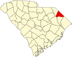
| State | South Carolina |
| County | Dillon |
| Area | |
• Total | 0.52 sq mi (1.35 km2) |
| • Land | 0.52 sq mi (1.35 km2) |
| • Water | 0 sq mi (0.00 km2) |
| Elevation | 112 ft (34 m) |
| Population | |
• Total | 770 |
| • Density | 1,479.8/sq mi (571.37/km2) |
| Time zone | UTC-5 (Eastern (EST)) |
| • Summer (DST) | UTC-4 (EDT) |
| ZIP Code | 29536 (Dillon) |
| Area codes | 843/854 |
| FIPS code | 45-50020 |
| GNIS feature ID | 2812950 [1] |
Newtown is an unincorporated community and census-designated place (CDP) in Dillon County, South Carolina, United States. It was first listed as a CDP prior to the 2020 census which listed a population of 770. [4]
Contents
The CDP is in central Dillon County, on the south side of Dillon, the county seat. Development is continuous between the two communities.
South Carolina Highway 57 passes through Newtown, leading north into Dillon and southeast 10 miles (16 km) to Fork.