Hamer, South Carolina

Last updated
Hamer, South Carolina
U.S. Route 301 501 in South Carolina (41327118392).jpg
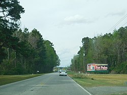
Driving northbound on US 301-501 just before entering Hamer.
USA South Carolina location map.svg
Red pog.svg
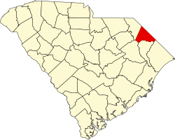
Hamer
Location within the state of South Carolina
Coordinates: 34°28′41″N79°19′51″W / 34.47806°N 79.33083°W / 34.47806; -79.33083 Coordinates: 34°28′41″N79°19′51″W / 34.47806°N 79.33083°W / 34.47806; -79.33083
Country United States
State South Carolina
County Dillon
Area
[1]
  Total5.06 sq mi (13.10 km2)
  Land5.04 sq mi (13.06 km2)
  Water0.02 sq mi (0.04 km2)
Population
 (2020) [2]
  Total820
  Density162.67/sq mi (62.80/km2)
Time zone UTC-5 (Eastern (EST))
  Summer (DST) UTC-4 (EDT)
ZIP code
29547 [3]
Area code(s) 843 and 854
FIPS code 45-31660
GNIS feature ID1222994

Hamer is an unincorporated community and census-designated place (CDP) in Dillon County, South Carolina, United States. It was first listed as a CDP in the 2020 census with a population of 820. [4]

Contents

Hamer is home to Hamer Hall, a residence from 1890 listed on the National Register of Historic Places. It is also the location of South of the Border, a famed tourist trap just before the state line with North Carolina; and it is the home of Blenheim Ginger Ale.

Geography

Its elevation is 144 feet (44 m). [5]

Demographics

Historical population
CensusPop.Note
2020 820
U.S. Decennial Census [6]
2020 [7] [2]

2020 census

Hamer CDP, South Carolina – Demographic Profile
(NH = Non-Hispanic)
Race / EthnicityPop 2020 [7] % 2020
White alone (NH)40249.02%
Black or African American alone (NH)32139.15%
Native American or Alaska Native alone (NH)232.80%
Asian alone (NH)40.49%
Pacific Islander alone (NH)00.00%
Some Other Race alone (NH)30.37%
Mixed Race/Multi-Racial (NH)303.66%
Hispanic or Latino (any race)374.51%
Total820100.00%

Note: the US Census treats Hispanic/Latino as an ethnic category. This table excludes Latinos from the racial categories and assigns them to a separate category. Hispanics/Latinos can be of any race.

Related Research Articles

Buford is an unincorporated community and census-designated place (CDP) in Lancaster County, South Carolina, United States. It was first listed as a CDP in the 2020 census with a population of 398. It lies at the intersection of South Carolina Highways 9 and 522.

Homewood is an unincorporated community and census-designated place (CDP) in Horry County, South Carolina, United States, just north of Conway in the northeastern part of the state. It was first listed as a CDP in the 2020 census with a population of 1,693.

Floyd Dale, shown on federal maps as Floydale, is an unincorporated community and census-designated place (CDP) in Dillon County, South Carolina, United States. It was first listed as a CDP in the 2020 census with a population of 421.

Pauline is an unincorporated community and census-designated place (CDP) in Spartanburg County, South Carolina, United States. It was first listed as a CDP in the 2020 census with a population of 209.

Beech Island is an unincorporated community and census-designated place (CDP) in Aiken County, South Carolina, United States. It was first listed as a CDP in the 2020 census with a population of 1,421.

<span class="mw-page-title-main">Springdale, North Carolina</span> Census-designated place in North Carolina, United States

Springdale is an unincorporated community and census-designated place (CDP) in Gaston County, North Carolina, United States. It was first listed as a CDP in the 2020 census with a population of 1,203. It is bordered on the west and south by the City of Gastonia, on the east by the town of Ranlo, and on the north by the unincorporated community of Monterey Park.

<span class="mw-page-title-main">Ketchuptown, South Carolina</span> Census-designated place in South Carolina, United States

Ketchuptown is a historic unincorporated community and census-designated place (CDP) located in Horry County, South Carolina, United States. Ketchuptown is at the intersection of Highways 23 and 99, about 9 miles (14 km) north of Aynor. As of the 2020 census, it had a population of 84.

DeBordieu Colony, DeBordieu Beach or simply DeBordieu is a private, unincorporated community and census-designated place (CDP) in Georgetown County, South Carolina, United States. It consists of approximately 2,700 acres (11 km2) of land, of which roughly 800 acres is wildlife preserve inaccessible to the citizens of Georgetown County. Parts of DeBordieu lie on Debidue Island. DeBordieu is located south of Pawleys Island and north of Georgetown east of U.S. Route 17. It is an oceanfront gated community with a private golf and country club.

Dacusville is a small unincorporated community and census-designated place (CDP) in Pickens County, South Carolina, United States. It is best known for its tractor show once a year in the month of September. The community also has an elementary school and a middle school. It was first listed as a CDP in the 2020 census with a population of 399.

<span class="mw-page-title-main">Litchfield Beach, South Carolina</span> Census-designated place in South Carolina, United States

Litchfield Beach, also known simply as Litchfield, is an unincorporated community and census-designated place (CDP) in South Carolina, United States. It was first listed as a CDP in the 2020 census with a population of 8,370.

Little Rock is an unincorporated community and census-designated place (CDP) in Dillon County, South Carolina, United States. Per the 2020 census, the population was 658.

<span class="mw-page-title-main">Conestee, South Carolina</span> Census-designated place in South Carolina, United States

Conestee is an unincorporated community and census-designated place (CDP) in Greenville County, South Carolina, United States. It was first listed as a CDP in the 2020 census with a population of 904.

Gillisonville is an unincorporated community and census-designated place (CDP) in Jasper County, in the U.S. state of South Carolina. It was first listed as a CDP in the 2020 census with a population of 183.

Cash is an unincorporated community and census-designated place (CDP) in Chesterfield County, in the U.S. state of South Carolina. It was first listed as a CDP in the 2020 census with a population of 445.

Pimlico is a housing development and census-designated place (CDP) in Berkeley County, South Carolina, United States. It was first listed as a CDP prior to the 2020 census with a population of 1,208.

Fairview Crossroads is an unincorporated community and census-designated place (CDP) in Lexington County, South Carolina, United States. It was first listed as a CDP prior to the 2020 census with a population of 540.

Ben Avon is an unincorporated area and census-designated place (CDP) adjacent to the city of Spartanburg in Spartanburg County, South Carolina, United States. It was first listed as a CDP prior to the 2020 census. The population as of 2020 was 2,428.

The Cliffs Valley is a resort community and census-designated place (CDP) in Greenville County, South Carolina, United States. It was first listed as a CDP prior to the 2020 census with a population of 736.

Camp Croft is an unincorporated area and census-designated place (CDP) in Spartanburg County, South Carolina, United States. It was first listed as a CDP prior to the 2020 census. The 2020 census lists a population of 2,110.

Whitney is an unincorporated area and census-designated place (CDP) adjacent to the city of Spartanburg in Spartanburg County, South Carolina, United States. It was first listed as a CDP prior to the 2020 census with a population of 4,409.

References

  1. "ArcGIS REST Services Directory". United States Census Bureau. Retrieved October 15, 2022.
  2. 1 2 "Census Population API". United States Census Bureau. Retrieved Oct 15, 2022.
  3. "Hamer SC ZIP Code". zipdatamaps.com. 2023. Retrieved February 17, 2023.
  4. "Hamer CDP, South Carolina". United States Census Bureau . Retrieved April 7, 2022.
  5. U.S. Geological Survey Geographic Names Information System: Hamer, South Carolina
  6. "Decennial Census of Population and Housing by Decades". US Census Bureau.
  7. 1 2 "P2 HISPANIC OR LATINO, AND NOT HISPANIC OR LATINO BY RACE – 2020: DEC Redistricting Data (PL 94-171) – Hamer CDP, South Carolina". United States Census Bureau .