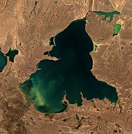
Lake Manasarovar, also called Mapam Yumtso locally, is a high altitude freshwater lake fed by the Kailash Glaciers near Mount Kailash in Burang County, Ngari Prefecture, Tibet Autonomous Region, China. The Indus River is near the lake. The lake along with Mount Kailash to its north are sacred sites in four religions: Hinduism, Jainism, Buddhism and Bön.

Lake Pelku, Pelkhu, or Paiku is a lake at 4,591 meters (15,062 ft) elevation on the Tibetan Plateau in Shigatse Prefecture. It is 18 kilometers (11 mi) south of the Yarlung Tsangpo (Brahmaputra) River, bordering Saga County, Gyirong County, and Nyalam County.

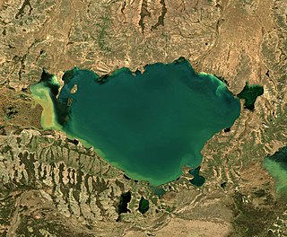
Puma Yumco is a lake located at 5,030 m (16,500 ft) above mean sea level on the southern Tibetan Plateau, and is situated within Nagarzê County of the Tibet Autonomous Region. It is 32 km (20 mi) long, 14 km (8.7 mi) wide, and covers an area of 280 km2 (110 sq mi). Streams of water from the snow-capped surrounding mountains feed the lake, and its water surplus flows into Yamdrok Lake via an outlet located at its southeastern end. Some sediment can be seen entering the lake at its western end.
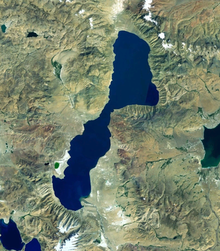
Yamdrok Lake is a freshwater lake in Tibet. It is one of the three largest lakes in Tibet. It is over 72 km (45 mi) long. The lake is surrounded by many snow-capped mountains and is fed by numerous small streams. The lake has an outlet stream, a tributary of Yarlung Tsangpo, at its far western end and means turquoise in English due to its color.

Haibei Tibetan Autonomous Prefecture is an autonomous prefecture of northeastern Qinghai Province, China. The prefecture has an area of 39,354 square kilometres (15,195 sq mi) and its seat is Haiyan County. Its name literally means "north of Qinghai Lake." This Tibetan culture area was incorporated into Qinghai province in the early 1950s, as it lies distant from the Tibet Autonomous Region.

Dragsum Tsho (Tibetan: བྲག་གསུམ་མཚོ་, Wylie: brag gsum mtsho, THL: Draksum Tso, Pagsum Co, literally meaning “three rocks” in Tibetan, is a lake covering 28 square kilometres in Gongbo'gyamda County, Nyingchi of the Tibet Autonomous Region, China, approximately 300 km east of Lhasa. At 3,700 metres over sea level it is about 18 km long and has an average width of approximately 1.5 km. The deepest point of the green lake measures 120 metres. The lake is also known as Gongga Lake.

Lumajangdong Co is a lake in the Ngari Prefecture, Tibet, China with an area of 250 km2. It is located at 34° 2' 0" and 81° 40' 0". Gormain lies a few miles (5–7 km) to the northwest.

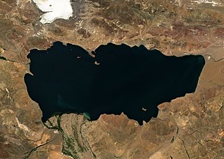
Siling Lake, is a salt lake in the Tibet Autonomous Region, China to the north of Xainza. Doijiang is located near the lake. Administratively it belongs to Xainza County and Baingoin County of the Nagqu.

Sengli Co or Senlicuo or Sengli Tso is a freshwater alpine lake of Zhongba County, Shigatse in Southern Tibet, China.

Zhari Namco or Zhari Nanmu or Lake Trari Nam is a salt lake in Tibet, China. It is bounded on the west by Coqên County of Ngari Prefecture, and on the east by Ngamring County of Shigatse Prefecture. Zhari Namco is 996.9 square kilometres (384.9 sq mi), with a drainage area of 15,433.2 square kilometres (5,958.8 sq mi), an elevation of 4,613 metres (15,135 ft), length 54.3 kilometres (33.7 mi) and mean width 18.36 kilometres (11.41 mi). It is located east of Coqên Town in southern Tibet.
Tangra Yumco is a salt lake in Tibet, China. It is in the southwest of Nyima County. Tangra Yumco is 835.8 square kilometres (322.7 sq mi), with a drainage area of 8,219.7 square kilometres (3,173.6 sq mi), an elevation of 4,528 metres (14,856 ft), length 71.7 kilometres (44.6 mi) and mean width 11.65 kilometres (7.24 mi). It is the holy lake of the Bön believers.
Gyaring Lake or Zhaling Lake is a large freshwater lake in the Yellow River catchment in China, it is in the southeast of Qinghai Province, on the border between Yushu Tibetan Autonomous Prefecture and Golog Tibetan Autonomous Prefecture. The lake's Tibetan name means "Long Gray Lake". Gyaring Lake is 526 km², with a drainage area of 8161 km², an elevation of 4292 m, a length of 35 km and a mean width of 15 km.

Jiesa Lake or Gyesar Tso is a lake in Coqên County in the Ngari Prefecture of the Tibet Autonomous Region of China.
Taruo Lake or Taruocuo, also known as Taro Tso is a lake in Zhongba County in the Shigatse Prefecture of the Tibet Autonomous Region of China. It is located about 70 kilometres west of Coqên Town. It is 38.1 km long and 17.2 km wide and has an area of 486.6 square km.

Renqingxiubu , or Renqingxiubucuo, also known as Rinchen Shubtso, is a salt lake in Zhongba County in the Shigatse Prefecture of the Tibet Autonomous Region of China. It is located about 45 kilometres northwest of Taruo Lake and southeast of Ang Laren Lake. It is 21.5 km long and 16.4 km wide and has an area of 187.1 square km.

Urru Lake (Tibetan: འུར་རུ་མཚོ, Wylie: ur ru mtsho; Chinese: 吴如错; pinyin: Wúrú Cuò)is a plateau lake in Nagqu Prefecture, Tibet Autonomous Region, southwest of China, located between Nyima County and Xainza County. The lake, which is part of the Siling Lake drainage system, is fed by several rivers and drains eastward into Jargö Lake. It is 33.6 km long and 13.4 km wide and has an area of 342.7 square km.
Jargö Lake or Qiagui Co and drains eastward into Siling Lake. It is 27.2 km long and 7.9 km wide and has an area of 88.5 square km.
Spanggur Tso, also called Maindong Tso, Mendong Tso, is a saltwater lake in Rutog County in the Tibet Autonomous Region of China, close to the border with Ladakh. India claims a major portion of the lake as its own territory, as part of Ladakh. To the west of the lake lies the Spanggur Gap, a low pass through which the Line of Actual Control runs. To the north is the much larger lake Pangong Tso. Spanggur Tso is at an elevation of 4,305 meters and has an area of 61.6 square kilometres. The lake's average annual temperature is around -4 to -2 °C, and the annual precipitation is 50 to 75 mm. The western portion of the lake is claimed by India.
Rakwa Tso, also known as Rawu Tso or Ranwu Lake, is a lake in Baxoi County, Chamdo Prefecture, Tibet Autonomous Region, China, to the north of Arza Gongla Glacier, and to the south of Ngagung Tso. The lake covers an area of 27 km2 (10 sq mi), and has an elevation of 3,850 metres. The lake was created by a landslide dam. Parlung River flows out of the lake.
Ngagung Tso is a lake in Baxoi County, Chamdo Prefecture, Tibet Autonomous Region, China, to the north of Rakwa Tso. The lake's length is 3.9 km, maximum width 2.1 km, average width 1.6 km. It covers an area of 6.1 km2. Parlung River flows out of the lake.