The Atlantic Ocean is the second-largest of the world's five oceans, with an area of about 106,460,000 km2 (41,100,000 sq mi). It covers approximately 20% of Earth's surface and about 29% of its water surface area. It is known to separate the "Old World" of Africa, Europe and Asia from the "New World" of the Americas in the European perception of the World.
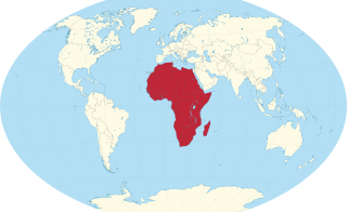
Africa is a continent comprising 63 political territories, representing the largest of the great southward projections from the main mass of Earth's surface. Within its regular outline, it comprises an area of 30,368,609 km2 (11,725,385 sq mi), excluding adjacent islands. Its highest mountain is Mount Kilimanjaro, its largest lake is Lake Victoria.

The Democratic Republic of the Congo (DRC) is the largest country of sub-Saharan Africa, occupying some 2,344,858 square kilometres (905,355 sq mi). Most of the country lies within the vast hollow of the Congo River basin. The vast, low-lying central area is a plateau-shaped basin sloping toward the west, covered by tropical rainforest and criss-crossed by rivers. The forest center is surrounded by mountainous terraces in the west, plateaus merging into savannas in the south and southwest. Dense grasslands extend beyond the Congo River in the north. High mountains of the Ruwenzori Range are found on the eastern borders with Rwanda and Uganda.

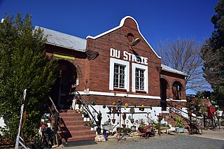
Mafikeng, officially known as Mahikeng and previously Mafeking, is the capital city of the North West province of South Africa.

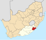
South Africa occupies the southern tip of Africa, its coastline stretching more than 2,850 kilometres from the desert border with Namibia on the Atlantic (western) coast southwards around the tip of Africa and then northeast to the border with Mozambique on the Indian Ocean. The low-lying coastal zone is narrow for much of that distance, soon giving way to a mountainous escarpment that separates the coast from the high inland plateau. In some places, notably the province of KwaZulu-Natal in the east, a greater distance separates the coast from the escarpment. Although much of the country is classified as semi-arid, it has considerable variation in climate as well as topography. The total land area is 1,220,813 km2 (471,359 sq mi). It has the 23rd largest Exclusive Economic Zone of 1,535,538 km2 (592,875 sq mi).
Norfolk is a town in Litchfield County, Connecticut, United States. The population was 1,588 at the 2020 census. The urban center of the town is the Norfolk census-designated place, with a population of 553 at the 2010 census.

Russia is a town in Herkimer County, New York, United States. The population was 2,587 at the 2010 census. The town is located in the northwestern part of the county and is northeast of Utica.

The mistral is a strong, cold, northwesterly wind that blows from southern France into the Gulf of Lion in the northern Mediterranean. It produces sustained winds often exceeding 66 km/h, sometimes reaching 185 km/h. It is most common in the winter and spring, and strongest in the transition between the two seasons. Periods of the wind exceeding 30 km/h for more than sixty-five hours have been reported.
The Harmattan is a season in West Africa that occurs between the end of November and the middle of March. It is characterized by the dry and dusty northeasterly trade wind, of the same name, which blows from the Sahara over West Africa into the Gulf of Guinea. The name is related to the word haramata in the Twi language. The temperature is cold in most places, but can also be hot in certain places, depending on local circumstances.

The Karoo is a semi-desert natural region of South Africa. No exact definition of what constitutes the Karoo is available, so its extent is also not precisely defined. The Karoo is partly defined by its topography, geology and climate, and above all, its low rainfall, arid air, cloudless skies, and extremes of heat and cold. The Karoo also hosted a well-preserved ecosystem hundreds of million years ago which is now represented by many fossils.

Paternoster is one of the oldest fishing villages on the West Coast of South Africa. It is situated 15 km north-west of Vredenburg and 145 km north of Cape Town, at Cape Columbine between Saldanha Bay and St Helena Bay. The town covers an area of 194.8 hectare and has approximately 1883 inhabitants.
Swartruggens is a small farming town in North West Province, South Africa that was established in 1875.

The Cacapon River, located in the Appalachian Mountains of West Virginia's Eastern Panhandle region, is an 81.0-mile-long (130.4 km) shallow river known for its fishing, boating, wildlife, hunting, and wilderness scenery. As part of the Potomac River watershed, it is an American Heritage River.
Halfway House Estate is a suburb of Johannesburg, South Africa. It is located in Region A and is part of the city known as Midrand.

The N2 is a national route in South Africa that runs from Cape Town through George, Gqeberha, East London, Mthatha, Port Shepstone and Durban to Ermelo. It is the main highway along the Indian Ocean coast of the country. Its current length of 2,255 kilometres (1,401 mi) makes it the longest numbered route in South Africa.
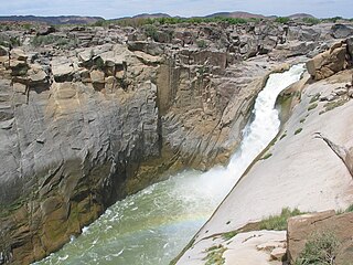
Augrabies Falls National Park is a national park located around the Augrabies Falls, about 120 km west of Upington in the Northern Cape Province, South Africa. It was established in 1966.

Noordhoek is a seaside town in the Western Cape, South Africa, located below Chapman's Peak on the west coast of the Cape Peninsula and is approximately 35 kilometres (22 mi) to the south of Cape Town. The name "Noordhoek" was taken from Dutch and literally means "north corner". It was given this name in 1743 as being the northern corner of the Slangkop farm. The first permanent resident of European origin is Jaco Malan who built his house there. In 1857, the region was divided into six plots, most of which were bought by a single family, that of the de Villiers. Noordhoek nevertheless remains a predominantly rural area where farmers grow vegetables to supply ships calling at Simon's Town. It is best known for its shoreline and its long, wide, sandy beach, which stretches south to the neighbouring village of Kommetjie. Near the southern end of this beach is the wreck of the steamship "Kakapo", which ran aground in 1900, when the captain mistook Chapman's Peak for the Cape of Good Hope and put the helm over to port.

Berg wind is the South African name for a katabatic wind: a hot dry wind blowing down the Great Escarpment from the high central plateau to the coast.

Spruce Mountain, located in eastern West Virginia, is the highest ridge of the Allegheny Mountains. The whale-backed ridge extends for only 16 miles (26 km) from northeast to southwest, but several of its peaks exceed 4,500 feet (1,400 m) in elevation. The summit, Spruce Knob, is the highest Allegheny Mountain point both in the state and the entire range, which spans four states.
Faure is a hamlet some 16 km south-west of Stellenbosch and 13 km north-west of Strand. Administratively it is a suburb of the City of Cape Town, and is in the Helderberg region. Nearby is the kramat or tomb of Sheik Yusuf (1626-1699), an Islamic expatriate priest. Faure is a common surname; it is uncertain after whom this place was named. It may have been named after Pieter Faure, the name of South Africa's first trawler which arrived in Table Bay in 1897.