Nob Hill, Hong Kong

Last updated
Nob Hill Nob Hill.jpg
Nob Hill
Lai Chi Kok Park and Nob Hill HK Lai Chi Kok Park views Nob Hill.JPG
Lai Chi Kok Park and Nob Hill
Nob Hill Household Centre, the shopping centre of Nob Hill HK Nob Hill Household Centre.JPG
Nob Hill Household Centre, the shopping centre of Nob Hill

Nob Hill (Chinese :盈暉臺) is a private housing estate in Mei Foo, Sham Shui Po/Kwai Chung, Kowloon, Hong Kong, located at the former site of Lai Chi Kok Amusement Park, together with Wah Lai Estate and Lai Yan Court. [1] It has totally 3 blocks [2] and it was jointly developed by Cheung Kong Holdings and Far East Hotels and Entertainment in 2002. [3]

Traditional Chinese characters Traditional Chinese characters

Traditional Chinese characters are Chinese characters in any character set that does not contain newly created characters or character substitutions performed after 1946. They are most commonly the characters in the standardized character sets of Taiwan, of Hong Kong and Macau, and in the Kangxi Dictionary. The modern shapes of traditional Chinese characters first appeared with the emergence of the clerical script during the Han Dynasty, and have been more or less stable since the 5th century.

Sham Shui Po Area of Kowloon, Hong Kong

Sham Shui Po is an area of Kowloon, Hong Kong, situated in the northwestern part of the Kowloon Peninsula, north of Tai Kok Tsui, east of Cheung Sha Wan and south of Shek Kip Mei 石硤尾. It is located in, and is the namesake of the Sham Shui Po District.

Kwai Chung geographical object

Kwai Chung is an urban area within Tsuen Wan New Town in the New Territories of Hong Kong. Together with Tsing Yi Island, it is part of the Kwai Tsing District District of Hong Kong. Kwai Chung is the site of the container port. It is also part of Tsuen Wan New Town. In 2000, it had a population of 287,000. Its area is 9.93 km². Areas within Kwai Chung include: Kwai Fong, Kwai Hing, Lai King, Tai Wo Hau.

Contents

District boundary issues

Nob Hill straddled at two different districts during the first few years after occupation. Block 1 and Lai Chi Kok Bus Terminus at its ground floor belonged to Sham Shui Po District while Block 2 and 3 belonged to Kwai Tsing District. [4] [5] However, this arrangement caused many inconvenience for handling district council matters. Some residents asked to assign the whole estate into Sham Shui Po District because the estate is near Mei Foo Sun Chuen. As a result, the government decided to put Nob Hill wholly into Sham Shui Po District in 2007. [6] [7]

Sham Shui Po District District in Kowloon, Hong Kong

Sham Shui Po District is one of 18 districts of Hong Kong. It is the poorest district in Hong Kong, with a predominantly working-class population of 405,869 in 2016 and the lowest median household income of all districts. Sham Shui Po has long been home to poorer new immigrants from mainland China. It also saw the birth of public housing in Hong Kong, as the government sought to resettle those displaced by a devastating fire in its slums. Sham Shui Po also hosted a Vietnamese refugee camp during the influx of migration in the aftermath of the Vietnam War.

Kwai Tsing District District in New Territories, Hong Kong

Kwai Tsing is one of the 18 districts of Hong Kong. It consists of two parts - Kwai Chung and Tsing Yi Island. Kwai Tsing is part of the New Territories. It had a population of 520 572 in 2016. The district has the third least educated residents and their income is below average.

Mei Foo Sun Chuen

Mei Foo Sun Chuen or simply Mei Foo (美孚) is a large private housing estate in Lai Chi Kok, Kowloon, Hong Kong. Mei Foo Sun Chuen was the first large scale private housing estate in Hong Kong and at the time of completion, the 99 tower complex was considered the largest private housing development in the world, accommodating some 70,000 – 80,000 people in 13,500 apartments. It is considered to be one of the world's largest privately financed residential condominium projects.

See also

Related Research Articles

Kowloon Place in Kowloon

Kowloon is an urban area in Hong Kong comprising the Kowloon Peninsula and New Kowloon. It is bordered by the Lei Yue Mun strait to the east, Mei Foo Sun Chuen and Stonecutter's Island to the west, a mountain range, including Tate's Cairn and Lion Rock to the north, and Victoria Harbour to the south. With a population of 2,019,533 and a population density of 43,033/km2 in 2006, it is the most populous urban area in Hong Kong. The peninsula's area is approximately 47 km2 (18 sq mi).

Cheung Sha Wan station MTR station in Kowloon, Hong Kong

Cheung Sha Wan is an underground station located underneath Cheung Sha Wan Road in Sham Shui Po District on the Tsuen Wan Line of Hong Kong MTR, between Sham Shui Po and Lai Chi Kok. It was opened in 1982. The station's livery is brass.

Castle Peak Road is the longest road in Hong Kong. Completed in 1933, it runs from Tai Po Road in Sham Shui Po, Kowloon to the very north of the New Territories, serving south, west and north New Territories, being one of the most distant roads in early Hong Kong.

Cheung Sha Wan

Cheung Sha Wan is an area between Lai Chi Kok and Sham Shui Po in New Kowloon, Hong Kong. It is mainly residential to the north and south, with an industrial area in between. Administratively it is part of Sham Shui Po District which includes Lai Chi Kok as well.

Lai Chi Kok Place in Sham Shui Po District

Lai Chi Kok is a neighborhood in New Kowloon, Hong Kong, east of Kwai Chung and west of Cheung Sha Wan. Mei Foo Sun Chuen is the largest housing estate in the area and also the largest in the HKSAR with 99 blocks. Administratively, it belongs to the Sham Shui Po District.

West Kowloon Corridor road in Hong Kong

West Kowloon Corridor is part of Route 5 in Hong Kong. Bypassing existing surface roads in West Kowloon, it connects Lai Chi Kok Road in Cheung Sha Wan with the Gascoigne Road Flyover near Yau Ma Tei.

Lai Chi Kok Road road in Hong Kong

Lai Chi Kok Road is a road in western New Kowloon, Hong Kong. It links Lai Chi Kok to Mong Kok, via Tai Kok Tsui, Sham Shui Po and Cheung Sha Wan. It starts from a junction with Nathan Road near Pioneer Centre in the south and ends near Mei Foo Sun Chuen. The road is bidirectional except the section at Lai Chi Kok, between the junction with Butterfly Valley Road and Mei Foo Sun Chuen, where it serves New Territories-bound traffic. The Kowloon-bound is left to Cheung Sha Wan Road, separated by the flyover of Kwai Chung Road.

Sham Shui Po Park

Sham Shui Po Park is a park in Sham Shui Po, New Kowloon, Hong Kong. It comprises two physically discontiguous sites on either side of Lai Chi Kok Road. The larger site is more well-known as Sham Shui Po Park. The smaller, located within Lai Kok Estate and originally managed by the Housing Authority, became part of Sham Shui Po Park when it was transferred to the Leisure and Cultural Services Department.

Dragon Centre shopping centre in Hong Kong

Dragon Centre is a nine-storey shopping centre in the Sham Shui Po area of Kowloon, Hong Kong. It was the largest in West Kowloon until the Elements opened above the Kowloon MTR station.

Sham Mong Road street in Hong Kong, Peoples Republic of China

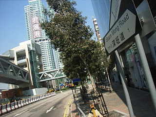
Sham Mong Road is a major road on the new reclamation of the 1990s in western Kowloon and New Kowloon of Hong Kong.

Pipers Hill

Piper's Hill is a hill north of Cheung Sha Wan in Kowloon of Hong Kong. Administratively, it is on the border between Sham Shui Po District and Sha Tin District.

Manhattan Hill building in Hong Kong, China

Manhattan Hill is a high-rise development located in the Lai Chi Kok district of Kowloon in Hong Kong, formerly Kowloon Motor Bus Lai Chi Kok Depot. The complex consists of five towers. Towers 1 and 2, which are interconnected, rise 51 floors, while towers 3, 5 and 6 rise 49 floors; each of the five towers is 198 metres (650 ft) high. The entire complex was developed by Sun Hung Kai Properties and was completed in January 2007.

Sham Shui Po Ferry Pier

Sham Shui Po Ferry Pier was a ferry pier in Sham Shui Po, Kowloon, Hong Kong that operated from 1924 to 1992. It was one of the important ferry piers in West Kowloon and had a bus terminus nearby.

Public housing estates in Kwai Chung

The following is an overview of public housing estates in Kwai Chung, Hong Kong, including Home Ownership Scheme (HOS), Private Sector Participation Scheme (PSPS), Sandwich Class Housing Scheme (SCHS), Flat-for-Sale Scheme (FFSS), and Tenants Purchase Scheme (TPS) estates.

Public housing estates in Cheung Sha Wan

The following is an overview of public housing estates in Cheung Sha Wan, Hong Kong, including Home Ownership Scheme (HOS), Private Sector Participation Scheme (PSPS), and Tenants Purchase Scheme (TPS) estates.

Public housing estates in Sham Shui Po

The following is an overview of public housing estates in Sham Shui Po, Hong Kong, including Home Ownership Scheme (HOS), Private Sector Participation Scheme (PSPS), and Tenants Purchase Scheme (TPS) estates.

Ching Lai Court

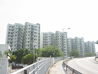
Ching Lai Court is a Home Ownership Scheme court in Lai Chi Kok, Kowloon, Hong Kong, located at the junction of Ching Cheung Road and Kwai Chung Road near Princess Margaret Hospital. Although it is situated at the south of Kwai Chung, it administratively belongs to Sham Shui Po District. It has totally 7 blocks and a shopping centre built in 1981.

References

Coordinates: 22°20′30″N114°08′15″E / 22.3418°N 114.1375°E / 22.3418; 114.1375

Geographic coordinate system Coordinate system

A geographic coordinate system is a coordinate system that enables every location on Earth to be specified by a set of numbers, letters or symbols. The coordinates are often chosen such that one of the numbers represents a vertical position and two or three of the numbers represent a horizontal position; alternatively, a geographic position may be expressed in a combined three-dimensional Cartesian vector. A common choice of coordinates is latitude, longitude and elevation. To specify a location on a plane requires a map projection.