North Bondi, New South Wales

Last updated

North Bondi
Sydney,  New South Wales
(1)Ben Buckler Bondi Beach.jpg
North Bondi's Ben Buckler
North Bondi, New South Wales
Map
Population9,165 (2016 census) [1]
 • Density7,274/km2 (18,840/sq mi)
Established1851
Postcode(s) 2026
Area1.26 km2 (0.5 sq mi)
Location7 km (4 mi) east of Sydney CBD
LGA(s) Waverley Council
State electorate(s) Vaucluse
Federal division(s) Wentworth
Suburbs around North Bondi:
Rose Bay Rose Bay Dover Heights
Bellevue Hill North Bondi Tasman Sea
Waverley Bondi Beach

North Bondi is a coastal, eastern suburb of Sydney, in the state of New South Wales, Australia 7 kilometres east of the Sydney central business district, in the local government area of Waverley Council.

Contents

North Bondi is a mostly residential area bordering Bondi Beach and the suburb of Bondi, as well as Bondi Junction, the commercial centre. Ben Buckler is a locality in North Bondi.

Campbell Parade, North Bondi, the site of the former semi underground tram cutting where trams once terminated Nthbondi..benbuckler.jpg
Campbell Parade, North Bondi, the site of the former semi underground tram cutting where trams once terminated

History

Bondi is an Aboriginal word meaning water breaking over rock. It has been spelled a number of different ways over time, Boondi, Bundi, Bundye. Aboriginal rock carvings can still be seen on a rocky surface between the sewerage ventilation shaft near Bondi Golf Course and the cliff.

A nearby group of carvings were done by Europeans; these were examined in 1910 by Lawrence Hargrave, who considered them to be the work of Spanish sailors who arrived in 1595. [3] However, more recent study has suggested that the carvings were in fact the work of quarrymen working at the nearby Murriverie Quarry, and were created between 1890 and 1915. [4] [5]

Another Aboriginal carving can be found at Ben Buckler, the headland immediately east of Bondi Beach. It is approximately a metre long and represents a turtle.

The whole Bondi area was part of an 81-hectare (200-acre) land grant to road-builder William Roberts in 1809. In 1851, Edward Smith Hall, editor of the Sydney Monitor, purchased the land for 200. [6]

Heritage listings

North Bondi has a number of heritage-listed sites, including:

Rathouse

On 22 March 1944, original members of the Rats of Tobruk formed the North Bondi Sub-Branch of the Returned and Services League of Australia and it is still known in modern times as Tobruk House or The Rathouse. [10] In 2003, the New York Times ran an article on The Rathouse calling it "an ideal beachside hang out." [11]

Ben Buckler Gun Battery

The Battery was constructed in 1892 and was intended to protect the colony and the approaches to Sydney Harbour from enemy vessels standing off the coast. During the 1950s the army vacated the premises and the fortification was buried. In the mid-1990s, the site was excavated by Water Board engineers planning to install a new pipeline. The site has been reburied and is currently under Hugh Bamford Reserve. [12] [13]

Tram to North Bondi

Residential development in North Bondi NorthBondi.jpg
Residential development in North Bondi

Tram services to North Bondi from the CBD operated from either Circular Quay (via Bridge and Elizabeth Streets) or Railway Square (via Elizabeth and Liverpool Streets), to Oxford Street. The line then passed down Oxford Street to Bondi Junction, where it branched off from Bronte services, to run down Bondi Road to Fletcher Street, Campbell Parade and then to the North Bondi tram terminus. A feature of this line was the large 3 track terminus cut into a hillside at North Bondi, which opened in 1946, as well as an underpass at 331a Bondi Road. Trams entered onto Campbell Parade via the under pass at a point where Bondi Road was too steep. The underpass and cutting have now been filled in, part of which is now public reserve and units. [14] [15]

The line opened in 1884 as a steam tramway to Bondi, then to Bondi Beach in 1894. Electric services commenced in 1902. The line closed in 1960. The tram line followed the current route of bus 380 as far as North Bondi.

The service also travelled via Paddington and Bellevue Hill. Heading south down Elizabeth Street from Circular Quay, the line turned left into Park Street, then wound through East Sydney. A feature was the tram only viaduct over Barcom Avenue and Boundary Street in Darlinghurst as the line headed into MacDonald Street. This viaduct is now a road bridge. The line then travelled to Paddington and down Curlewis Street in Bondi to join the Bondi Beach via the Bondi Junction line on Campbell Parade, to the North Bondi terminus. The line follows approximately the current route of bus 389. [2]

Population

In the 2016 Census, there were 9,165 people in North Bondi. 56.3% of people were born in Australia. The next most common countries of birth were England 7.2%, South Africa 5.6%, New Zealand 2.5%, United States of America 1.6% and Brazil 1.4%. 75.0% of people spoke only English at home. Other languages spoken at home included Hebrew 1.8%, Italian 1.7%, Portuguese 1.6%, French 1.5% and Spanish 1.4%. The most common responses for religion were No Religion 32.6%, Judaism 21.9% and Catholic 18.4%. [1]

Landmarks

Residential area in North Bondi Nthbondi1234.jpg
Residential area in North Bondi
North Bondi Surf Life Saving Club North Bondi Surf Life Saving Club.jpg
North Bondi Surf Life Saving Club

Sport and recreation

Since 1908, North Bondi has been represented in one of Australia's most popular sporting competitions, the National Rugby League, by the Sydney Roosters, officially known as the Eastern Suburbs District Rugby League Football Club.

Related Research Articles

Bondi Junction, New South Wales Suburb of Sydney, New South Wales, Australia

Bondi Junction is an eastern suburb of Sydney, in the state of New South Wales, Australia. It is 6 kilometres east of the Sydney central business district and is part of the local government area of Waverley.

Bronte, New South Wales Suburb of Sydney, New South Wales, Australia

Bronte is a beachside suburb of Sydney, in the state of New South Wales, Australia. Bronte Beach is located 7 kilometres east of the Sydney central business district, in the Waverley Council local government area of the Eastern Suburbs.

North Sydney, New South Wales Suburb of Sydney, New South Wales, Australia

North Sydney is a suburb and major commercial district on the Lower North Shore of Sydney, Australia. North Sydney is located 3 kilometres north of the Sydney central business district and is the administrative centre for the local government area of North Sydney Council.

Paddington, New South Wales Suburb of Sydney, New South Wales, Australia

Paddington is an upscale inner-city area of Sydney, in the state of New South Wales, Australia. Located 3 kilometres (1.9 mi) east of the Sydney central business district, Paddington lies across two local government areas. The portion south of Oxford Street lies within the City of Sydney, while the portion north of Oxford Street lies within the Municipality of Woollahra. It is often colloquially referred to as "Paddo".

Bellevue Hill, New South Wales Suburb of Sydney, New South Wales, Australia

Bellevue Hill is a harbourside eastern suburb of Sydney, in the state of New South Wales, Australia, located 5 kilometres east of the Sydney central business district, in the Municipality of Woollahra.

Malabar, New South Wales Suburb of Sydney, New South Wales, Australia

Malabar is a suburb in south-eastern Sydney, in the state of New South Wales, Australia 12 kilometres south-east of the Sydney central business district, in the local government area of the City of Randwick.

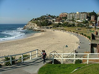
Bondi is a suburb of eastern Sydney, in the state of New South Wales, Australia, seven kilometres east of the Sydney central business district, in the local government area of Waverley Council. It is often colloquially referred to as "Bondy".

Ben Buckler is an urban locality in the eastern suburbs of Sydney, in the state of New South Wales, Australia. It is part of the suburb of North Bondi in the Waverley Council local government area. It is sometimes referred to simply as "the northern headland of Bondi Bay."

Trams in Sydney

The Sydney tramway network served the inner suburbs of Sydney, Australia from 1879 until 1961. In its heyday, it was the largest in Australia, the second largest in the Commonwealth of Nations, and one of the largest in the world. The network was heavily worked, with about 1,600 cars in service at any one time at its peak during the 1930s . Patronage peaked in 1945 at 405 million passenger journeys. Its maximum street trackage totalled 291 km in 1923.

Johnstons Creek (New South Wales)

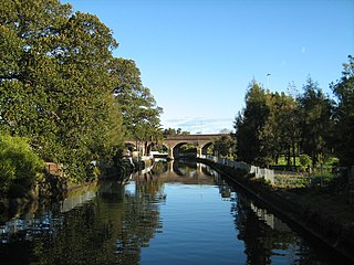
Johnstons Creek, formerly Johnston's Creek, is an urban gully, located in Sydney, Australia and situated in the Leichhardt local government area. The creek flows from Petersham, past Annandale, Camperdown, Forest Lodge and Harold Park, before spilling into Rozelle Bay, within Sydney Harbour.

Bondi Road Road in Sydney, Australia

Bondi Road is a road in the Sydney suburb of Bondi, Australia. The road traverses east from Syd Einfeld Drive in Bondi Junction to Campbell Parade, Bondi Beach. It is 1.8 kilometres long and is located in the local government area of Waverley Council.

Bondi Sewer Vent

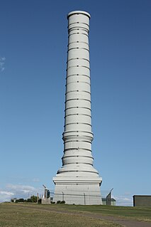
The Bondi Sewer Vent is a heritage-listed sewer vent shaft located at Military Road, North Bondi, Waverley Municipality, New South Wales, Australia. It was designed by the Metropolitan Board of Water Supply and Sewerage. It is also known as Sewer Vent , Ben Buckler and Earlier brick vent. The property is owned by Sydney Water, an agency of the Government of New South Wales. It was added to the New South Wales State Heritage Register on 15 November 2002.

The Bondi Ocean Outfall Sewer is a heritage-listed sewerage infrastructure at Blair Street, North Bondi, Waverley Municipality, New South Wales, Australia. The sewer line commences at the intersection of Oxford Street and College Street in Darlinghurst and then travels in a more-or-less easterly direction for 6.1 kilometres (3.8 mi) passing through a number of suburbs until it reaches Blair Street in North Bondi. It was designed and built by the Public Works Department between 1880 and 1889. It is also known as BOOS and Main Northern Ocean Outfall Sewer. The property is owned by Sydney Water, an agency of the Government of New South Wales. It was added to the New South Wales State Heritage Register on 15 November 2002.

Western Outfall Main Sewer

Western Outfall Main Sewer is a heritage-listed former sewage farm outfall sewer and now ocean outfall sewer near Valda Avenue, Arncliffe, Bayside Council, New South Wales, Australia. It was designed by the New South Wales Department of Public Works, who built the sewer from 1895 to 1898. It is also known as SWSOOS No. 1, Western Main Carrier and Western Main Outfall Sewer. The property is owned by Sydney Water. It was added to the New South Wales State Heritage Register on 15 November 2002.

Double Bay Compressed Air Ejector Station

The Double Bay Compressed Air Ejector Station is a heritage-listed former sewage pumping station (SPS87) and now decommissioned sewerage infrastructure in Jamberoo Lane, Double Bay, adjacent to the rear boundary of 63 William Street, in the Municipality of Woollahra local government area of New South Wales, Australia. The site of the pumping station and the State Heritage Register curtilage is shown on SHR:01324–Plan 2019, reproduced on the internet page referenced here.

Whites Creek Aqueduct Heritage-listed sewage aqueduct in Sydney, Australia

White's Creek Aqueduct is a heritage-listed sewage aqueduct at Piper Street, Lilyfield, Inner West Council, Sydney, New South Wales, Australia. It was designed by engineer William Julius Baltzer of the New South Wales Public Works Department and built by the Department from 1897 to 1898. The property is owned by Sydney Water. It was added to the New South Wales State Heritage Register on 18 November 1999.

Johnstons Creek Sewer Aqueduct Located in Sydney, Australia

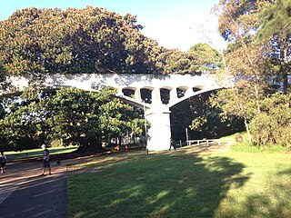
Johnston's Creek Sewer Aqueduct is a heritage-listed sewage aqueduct located in Hogan Park, off Taylor Street, Annandale, Inner West Council, Sydney, New South Wales, Australia. It was designed by William Julius Baltzer, an engineer in the NSW Public Works Department, and built by the Department in 1897. The property is owned by Sydney Water. It was added to the New South Wales State Heritage Register on 18 November 1999.

Ultimo Sewage Pumping Station

The Ultimo Sewage Pumping Station is a heritage-listed sewerage pumping station located at William Henry Street in the inner city Sydney suburb of Ultimo in the City of Sydney local government area of New South Wales, Australia. As a result of the construction of an elevated roadway along William Henry Street, the pumping station now fronts Pyrmont Street, with vehicles being required to enter via Quarry Street, then turning right into Pyrmont Street.

Rushcutters Bay Sewage Pumping Station

The Rushcutters Bay Sewage Pumping Station is a heritage-listed sewerage pumping station located at Rushcutters Bay Park in the inner city Sydney suburb of Rushcutters Bay in the City of Sydney local government area of New South Wales, Australia. It was designed and built by the New South Wales Public Works Department from 1902 to 1904. It is also known as Sewage Pumping Station 18 and SPS 18. The property is owned by Sydney Water, an agency of the Government of New South Wales. It was added to the New South Wales State Heritage Register on 18 November 1999.

Sewage Pumping Station 3

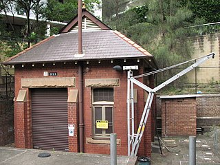
Sewage Pumping Station 3 is a heritage-listed sewerage pumping station located near 1 Booth Street, Annandale, City of Sydney, New South Wales, Australia. The building is located adjacent to Johnstons Creek. It was built from 1902 to 1904 by the New South Wales Public Works Department. It is also known as SPS 3, SP0003, Booth Street Sewage Pumping Station and Annandale Sewage Pumping Station. The property is owned by Sydney Water. It was added to the New South Wales State Heritage Register on 18 November 1999.

References

  1. 1 2 Australian Bureau of Statistics (27 June 2017). "North Bondi (State Suburb)". 2016 Census QuickStats. Retrieved 21 October 2018. OOjs UI icon edit-ltr-progressive.svg CC-BY icon.svg Material was copied from this source, which is available under a Creative Commons Attribution 4.0 International License.
  2. 1 2 "Archived copy". Archived from the original on 22 September 2010. Retrieved 29 January 2010.{{cite web}}: CS1 maint: archived copy as title (link)
  3. visitsydneyaustralia.com.au
  4. State Heritage Register
  5. timalderman.com
  6. Pollon, Frances, ed. (1990). The Book of Sydney Suburbs. Angus & Robertson. p. 33. ISBN   0-207-14495-8.
  7. "Ben Buckler Gun Battery 1893, 9.2 Disappearing Gun". New South Wales State Heritage Register . Office of Environment & Heritage. H01742. Retrieved 18 May 2018.
  8. "BOOS (Bondi Ocean Outfall Sewer)". New South Wales State Heritage Register . Office of Environment & Heritage. H01623. Retrieved 18 May 2018.
  9. "Sewer Vent (Ben Buckler)". New South Wales State Heritage Register . Office of Environment & Heritage. H01637. Retrieved 18 May 2018.
  10. "The Rathouse History". Tobrukhouse.com. Retrieved 6 September 2009.
  11. Borden, Margaret (16 November 2003). "Bondi, Beyond The Beach" (Section 5). The New York Times . p. 10.
  12. Welcome to Waverley Library Archived 1 September 2007 at the Wayback Machine
  13. NSW Heritage Office Website – Listing Heritage Items – State Heritage Register – Item View
  14. "Archived copy". Archived from the original on 29 October 2010. Retrieved 5 October 2010.{{cite web}}: CS1 maint: archived copy as title (link)
  15. "打开微信小程序".

Coordinates: 33°53′16″S151°16′51″E / 33.88778°S 151.28083°E / -33.88778; 151.28083