History
The North London Railway (NLR) was founded in 1850 with the intention of operating a network of railway lines throughout north London that connected to the East India and West India Docks. The company's main headquarters was at Bow, and from there a connection to the London and Blackwall Railway's route allowed the NLR's trains access to a terminus in the City of London, in this case Fenchurch Street. However, this meant that, in order to reach the City, the NLR's trains had to take a fairly circuitous route, and so the company decided to build its own central terminus.
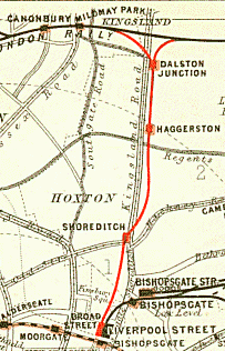
In 1861, the North London Railway Act was passed giving permission to the NLR to build an extension from its main line through Hackney to a site at Old Broad Street. The majority of the route was built on a viaduct from Dalston, with a triangular junction allowing access to the main line in both directions. The extension had four new stations:
Passenger services along the Kingsland Viaduct to Broad Street began in November 1865. Initially, the branch had three running lines; a fourth line was added in 1874. The route was electrified in 1916 using the 600 V DC third and fourth rail system, with the purchase of new electric rolling stock. However, only the western five platforms at Broad Street were electrified.
Both Haggerston and Shoreditch stations, as well as the rest of the branch, received heavy damage in the Second World War, and were closed in 1940, leaving Dalston Junction as the only intermediate station between Broad Street and the main line. At this time, passenger numbers on the branch were declining. The eastern route to Poplar was closed in 1944, while services from the rest of London declined. The route was earmarked for closure under the Beeching Axe in 1963, but remained open due to local pressure. However, the opening of other routes led to further services being withdrawn until it was decided in 1985 that the route would be mothballed. By then Dalston Kingsland had opened to serve the Dalston area, and both Dalston Junction and Broad Street were closed.
The East London line is part of the London Overground, running north to south through the East, Docklands and South areas of London. It was previously a line of the London Underground.
Dalston is an area of East London, in the London Borough of Hackney. It is 4 miles (6.4 km) north-east of Charing Cross. Dalston began as a hamlet on either side of Dalston Lane, and as the area urbanised the term also came to apply to surrounding areas including Kingsland and Shacklewell, all three of which being part of the Ancient Parish of Hackney.

The North London line (NLL) is a railway line which passes through the inner suburbs of west, north-west, north, and east London, England between Richmond in the south-west and Stratford in the east, avoiding central London. Its route is a rough semicircle.

Shadwell is a London Overground station in Shadwell in East London. It was formerly a London Underground station on the East London line until 2007. The station is between Whitechapel to the north and Wapping to the south. It is located near to Shadwell DLR station. The station is in Travelcard Zone 2.

Whitechapel is a London Underground and London Overground station located on Whitechapel Road and Durward Street in the Whitechapel area of London, United Kingdom. The station is located behind a street market of the same name and opposite the Royal London Hospital. It lies between Aldgate East and Stepney Green stations on the District and Hammersmith & City lines, and between Shoreditch High Street and Shadwell stations on the East London Line. It is in Travelcard Zone 2.

Broad Street was a major terminal station in the City of London, adjacent to Liverpool Street station. It served as the main terminus of the North London Railway (NLR) network, running from 1865 to 1986. During its lifetime, it catered for mainly local suburban services around London, and over time struggled to compete with other modes of transport, leading to its closure.

Queens Road Peckham railway station is in the London Borough of Southwark and also serves the area to the east of Peckham, in the London Borough of Lewisham. It is on the South London Line, 2 miles 58 chains (4.4 km) from London Bridge, and trains also go to Croydon via various routes and beyond. It is on the road of that name and is in Travelcard Zone 2.
The North London Railway (NLR) company had lines connecting the northern suburbs of London with the East and West India Docks further east. The main east to west route is now part of London Overground's North London Line. Other NLR lines fell into disuse but were later revived as part of the Docklands Light Railway, and London Overground's East London Line. The company was originally called the East & West India Docks & Birmingham Junction Railway (E&WID&BJR) from its start in 1850, until 1853. in 1909 it entered into an agreement with the London and North Western Railway which introduced common management, and the NLR was taken over completely by the LNWR in 1922. The LNWR itself became part of the LMS from the start of 1923. The railways were nationalised in 1948 and most LMS lines, including the North London route, then came under the control of the London Midland Region of British Railways.

Bow Road is a closed railway station in Bow, East London, that was opened in 1876 on the Bow Curve branch line by the Great Eastern Railway (GER).

Dalston Kingsland railway station is a railway station on the North London Line in London, England. It is in the Dalston area of the London Borough of Hackney, on the western side of Kingsland High Street and opposite Ridley Road Market. The station and all trains serving it are operated by London Overground. It is in Travelcard Zone 2. Kingsland railway station was first opened on the site in 1850, but was replaced by Dalston Junction in 1865. The current station was opened by British Rail in 1983. Ticket barriers are in operation. The station straddles the boundary with the London Borough of Islington, with part of the platforms falling within Islington.
Shoreditch was a railway station on the North London Railway (NLR) in Shoreditch, London, that was in use from 1865 to 1940. It was situated on a viaduct between Haggerston and Broad Street stations. It should not be confused with Shoreditch Underground station (1869–2006) on the London Underground, situated about half a mile further south. It was also not the first main line railway station to possess the Shoreditch name; Bishopsgate (1840–1875) was originally given that name.

Dalston Junction is an inter-modal rail and bus transport interchange in Dalston, London. It is located at the crossroads of Dalston Lane, Kingsland Road and Balls Pond Road. The station served by London Overground East London line and is in Zone 2. The station is located in a short section of cut and cover tunnel north of the Kingsland Viaduct.

Bow was a railway station in Bow, east London, that was opened in 1850 by the East & West India Docks and Birmingham Junction Railway, which was later renamed the North London Railway (NLR). The station was situated between Old Ford and South Bromley, and was located on the north side of Bow Road, close to the second Bow Road station which was open from 1892 to 1949. A covered footway connected the two stations between 1892 and 1917.

Shoreditch High Street is a London Overground station on Bethnal Green Road in Shoreditch, in East London. It is served by the East London Line between Whitechapel and Hoxton with services running either to Dalston Junction, Highbury & Islington or New Cross, New Cross Gate, West Croydon, Crystal Palace, and is in Travelcard Zone 1.

Hoxton is a station on the East London line in the London Borough of Hackney, Greater London. It is on the Kingsland Viaduct and served by London Overground. The station entrance is on Geffrye Street near Dunloe Street and Cremer Street, behind the Museum of the Home.

Haggerston is a station on the East London line in Haggerston within the London Borough of Hackney, Greater London. The station is located on the Kingsland Viaduct at the junction of Arbutus Street and Frederick Terrace, near Kingsland Road. The main entrance is in Lee Street. The station was built as part of the East London line extension served by National Rail London Overground under the control of the London Rail division of Transport for London, however there is no standard red National Rail "double arrow" logo signage located at the station, instead only the Overground roundel. The next station north is Dalston Junction and the next station south is Hoxton. It is in Travelcard Zone 2.
Poplar was a railway station located on the East India Dock Road in Poplar, London. It was opened in 1866 by the North London Railway. It was the southern passenger terminus of the NLR, although goods trains ran on to connect to the London and Blackwall Railway (LBR) for the East India Docks or to the LBR's Millwall Extension Railway for the West India Docks.
The Eastern Counties and Thames Junction Railway in east London connected the Royal Docks with the Eastern Counties Railway (ECR). Authorised in 1844, it opened in 1846, and was absorbed by the ECR in 1847. The ECR amalgamated with other railways to form the Great Eastern Railway in 1862.
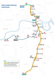
The East London line extension (ELLX) project was a British railway engineering project in London, managed by Transport for London. The project involved extending the East London Line and making it part of the mainline London Overground network. This was done by re-opening sections of disused railway line and by converting track electrified by the third-rail system, signalling, lineside signage and communication systems, etc. to mainline standards. New rolling stock was introduced and four new stations built along the route, with a fifth scheduled to be added in the future at New Bermondsey.
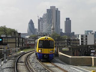
Kingsland Viaduct is a railway viaduct about 2 miles (3 km) in length, almost wholly within the present London Borough of Hackney in the north-east part of Inner London. It was built in the 1860s, but was disused from 1986 until it was reopened to carry the London Overground in 2010. The viaduct is owned by Transport for London. Since then it has carried East London Line services between Shoreditch High Street and Dalston.

