Northwest Ithaca, New York

Last updated

Northwest Ithaca, New York
CDP
USA New York location map.svg
Red pog.svg
Northwest Ithaca, New York
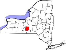
Location within the state of New York
Coordinates: 42°28′4″N76°32′20″W / 42.46778°N 76.53889°W / 42.46778; -76.53889
Country United States
State New York
County Tompkins
Area
[1]
  Total3.56 sq mi (9.22 km2)
  Land3.55 sq mi (9.20 km2)
  Water0.01 sq mi (0.01 km2)
Population
 (2020)
  Total2,231
  Density627.74/sq mi (242.40/km2)
Time zone UTC-5 (Eastern (EST))
  Summer (DST) UTC-4 (EDT)
FIPS code 36-53853

Northwest Ithaca is a census-designated place (CDP) in Tompkins County, New York, United States. The population was 1,115 at the 2000 census.

Contents

Geography

Northwest Ithaca is located at 42°28′4″N76°32′20″W / 42.46778°N 76.53889°W / 42.46778; -76.53889 (42.467894, -76.538980). [2]

According to the United States Census Bureau, the CDP has a total area of 3.6 square miles (9.3 km2), of which, 2.9 square miles (7.5 km2) of it is land and 0.6 square miles (1.6 km2) of it (17.88%) is water.

Demographics

Historical population
CensusPop.Note
2020 2,231
U.S. Decennial Census [3]

As of the census [4] of 2000, there were 1,115 people, 463 households, and 220 families residing in the CDP. While the CDP is called Northwest Ithaca, most residents refer to the area as West Hill, a designation shared with the contiguous area within the City of Ithaca. The population density was 379.8 inhabitants per square mile (146.6/km2). There were 559 housing units at an average density of 190.4 per square mile (73.5/km2). The racial makeup of the CDP was 93.36% White, 2.33% African American, 0.09% Native American, 1.88% Asian, 1.08% from other races, and 1.26% from two or more races. Hispanic or Latino of any race were 1.70% of the population.

There were 463 households, out of which 20.3% had children under the age of 18 living with them, 41.3% were married couples living together, 4.1% had a female householder with no husband present, and 52.3% were non-families. 42.5% of all households were made up of individuals, and 16.0% had someone living alone who was 65 years of age or older. The average household size was 2.02 and the average family size was 2.76.

In the CDP, the population was spread out, with 14.6% under the age of 18, 6.5% from 18 to 24, 24.7% from 25 to 44, 22.7% from 45 to 64, and 31.6% who were 65 years of age or older. The median age was 47 years. For every 100 females, there were 84.6 males. For every 100 females age 18 and over, there were 77.6 males.

The median income for a household in the CDP was $47,500, and the median income for a family was $62,292. Males had a median income of $50,114 versus $41,250 for females. The per capita income for the CDP was $31,271. About 4.4% of families and 4.9% of the population were below the poverty line, including 2.5% of those under age 18 and 7.7% of those age 65 or over.

Related Research Articles

<span class="mw-page-title-main">Three Oaks, Florida</span> Census-designated place in Florida, United States

Three Oaks is a census-designated place (CDP) in Lee County, Florida, United States. The population was 3,592 at the 2010 census, up from 2,255 at the 2000 census. It is part of the Cape Coral-Fort Myers, Florida Metropolitan Statistical Area.

<span class="mw-page-title-main">Three Lakes, Florida</span> Census-designated place in Florida, United States

Three Lakes is a census-designated place (CDP) in Miami-Dade County, Florida, United States. The population was 16,540 at the 2020 census, up from 15,047 in 2010. Its name comes from the planned community of Three Lakes, which is located inside Three Lakes CDP boundaries.

<span class="mw-page-title-main">Deale, Maryland</span> Census-designated place in Maryland, United States

Deale is a census-designated place (CDP) in Anne Arundel County, Maryland, United States. The population was 4,945 at the 2010 census. It has a scenic view of Chesapeake Bay and is popular with boaters. Sudley was listed on the National Register of Historic Places in 1973.

<span class="mw-page-title-main">Dunkirk, Maryland</span> Census-designated place in Maryland, United States

Dunkirk is a census-designated place (CDP) in Calvert County, Maryland, United States. The population was 2,521 at the 2010 census.

<span class="mw-page-title-main">Pinehurst, Massachusetts</span> Census-designated place in Massachusetts, United States

Pinehurst is an unincorporated village and census-designated place (CDP) in the town of Billerica, Middlesex County, Massachusetts, United States. The population was 7,368 at the 2020 census. It is in the southeastern part of town along Massachusetts Route 3A.

Melrose Park is a suburban community and census-designated place (CDP) in Cayuga County, New York, United States. The population was 2,294 at the 2010 census. It is a suburb of Auburn, located south of the city in the town of Owasco.

Munsons Corners is a hamlet and census-designated place (CDP) in Cortland County, New York, United States. The population was 2,728 at the 2010 census.

<span class="mw-page-title-main">Mattydale, New York</span> Census-designated place in New York, United States

Mattydale is a hamlet in Onondaga County, New York, United States. The population was 6,446 at the 2010 census.

East Ithaca is a suburban community in Tompkins County, New York, United States. The population was 2,231 at the 2010 census.

<span class="mw-page-title-main">Forest Home, New York</span> CDP in New York, United States

Forest Home is a census-designated place (CDP) in Tompkins County, New York, United States. The population was 572 at the 2010 census.

Newfield is a census-designated place (CDP) in Tompkins County, New York, United States. The population was 759 at the 2010 census.

Northeast Ithaca is a census-designated place (CDP) in Ithaca (town), New York in Tompkins County, New York, United States. The population was 2,655 at the 2000 census.

<span class="mw-page-title-main">South Hill, New York</span> CDP in New York, United States

South Hill is a census-designated place (CDP) in Tompkins County, New York, United States. The population was 7,245 at the 2020 census.

<span class="mw-page-title-main">West Hurley, New York</span> CDP in New York, United States

West Hurley is a hamlet in Ulster County, New York, United States. The population was 1,917 at the 2020 census.

<span class="mw-page-title-main">Iola, Pennsylvania</span> Census-designated place in Pennsylvania, United States

Iola is a census-designated place in Columbia County, Pennsylvania, United States. It is part of Northeastern Pennsylvania. The population was 144 at the 2010 census. It is part of the Bloomsburg-Berwick micropolitan area.

Locustdale is a census-designated place (CDP) that is located on the border of Columbia and Schuylkill counties, Pennsylvania, United States. It is part of Northeastern Pennsylvania.

<span class="mw-page-title-main">Hudson Bend, Texas</span> CDP in Texas, United States

Hudson Bend is a census-designated place (CDP) in Travis County, Texas, United States. The population was 2,981 at the 2010 census.

Laredo Ranchettes is a census-designated place (CDP) in Webb County, Texas, United States. The population was 22 at the 2010 census.

<span class="mw-page-title-main">Mirrormont, Washington</span> Census-designated place in Washington, United States

Mirrormont is a census-designated place (CDP) in King County, Washington, United States, south of Issaquah. The population was 3,858 at the 2020 census. Within the last decade, the area has seen a shift in development as larger homes have been constructed in Cedar Grove, the Highlands at Tiger Mountain and Mirrormont.

Big Flats is an unincorporated community and census-designated place (CDP) within the town of Big Flats in Chemung County, New York, United States. The population of the CDP was 5,277 at the 2010 census, out of a total population in the town of 7,595.

References

  1. "ArcGIS REST Services Directory". United States Census Bureau. Retrieved September 20, 2022.
  2. "US Gazetteer files: 2010, 2000, and 1990". United States Census Bureau. February 12, 2011. Retrieved April 23, 2011.
  3. "Census of Population and Housing". Census.gov. Retrieved June 4, 2016.
  4. "U.S. Census website". United States Census Bureau . Retrieved January 31, 2008.