Norwood, Louisiana

Last updated

Norwood, Louisiana
Village
East Feliciana Parish Louisiana Incorporated and Unincorporated areas Norwood Highlighted.svg
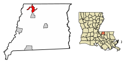
Location of Norwood in East Feliciana Parish, Louisiana.
Louisiana in United States (US48).svg
Location of Louisiana in the United States
Coordinates: 30°58′10″N91°06′20″W / 30.96944°N 91.10556°W / 30.96944; -91.10556
CountryUnited States
StateLouisiana
Parish East Feliciana
Area
[1]
  Total4.10 sq mi (10.62 km2)
  Land4.08 sq mi (10.58 km2)
  Water0.02 sq mi (0.04 km2)
Elevation
312 ft (95 m)
Population
 (2020)
  Total279
  Density68.33/sq mi (26.38/km2)
Time zone UTC-6 (CST)
  Summer (DST) UTC-5 (CDT)
Area code 225
FIPS code 22-56295

Norwood is a village in East Feliciana Parish, Louisiana, United States. The population was 322 at the 2010 census. [2] It is part of the Baton Rouge Metropolitan Statistical Area.

Contents

Geography

Norwood is located in northwestern East Feliciana Parish at 30°58′10″N91°6′20″W / 30.96944°N 91.10556°W / 30.96944; -91.10556 (30.969430, -91.105509). [3] Louisiana Highway 19 passes through the village, leading south 39 miles (63 km) to Baton Rouge and north 2 miles (3 km) to the Mississippi border. Centreville, Mississippi, and Clinton, the East Feliciana Parish seat, is 10 miles (16 km) to the southeast.

According to the United States Census Bureau, Norwood has a total area of 4.1 square miles (10.6 km2), of which 0.02 square miles (0.04 km2), or 0.40%, is water. [2]

Demographics

Historical population
CensusPop.Note
1950 414
1960 4273.1%
1970 348−18.5%
1980 42121.0%
1990 317−24.7%
2000 3376.3%
2010 322−4.5%
2020 279−13.4%
U.S. Decennial Census [4]
Norwood racial composition as of 2020 [5]
RaceNumberPercentage
White (non-Hispanic)21777.78%
Black or African American (non-Hispanic)6021.51%
Hispanic or Latino 20.72%

As of the 2020 United States census, there were 279 people, 127 households, and 71 families residing in the village.

Notable people

Related Research Articles

<span class="mw-page-title-main">Wilkinson County, Mississippi</span> County in Mississippi, United States

Wilkinson County is a county located in the southwest corner of the U.S. state of Mississippi. As of 2020, its population was 8,587. Its county seat is Woodville. Bordered by the Mississippi River on the west, the county is named for James Wilkinson, a Revolutionary War military leader and first governor of the Louisiana Territory after its acquisition by the United States in 1803.

<span class="mw-page-title-main">West Feliciana Parish, Louisiana</span> Parish in Louisiana, United States

West Feliciana Parish is a civil parish located in the U.S. state of Louisiana. At the 2020 census, the population was 15,310. The parish seat is St. Francisville. The parish was established in 1824.

<span class="mw-page-title-main">West Baton Rouge Parish, Louisiana</span> Parish in Louisiana, United States

West Baton Rouge Parish is one of the sixty-four parishes in the U.S. state of Louisiana. Established in 1807, its parish seat is Port Allen. With a 2020 census population of 27,199 residents, West Baton Rouge Parish is part of the Baton Rouge metropolitan statistical area.

<span class="mw-page-title-main">East Feliciana Parish, Louisiana</span> Parish in Louisiana, United States

East Feliciana Parish is a parish located in the U.S. state of Louisiana. At the 2020 census, the population was 19,531. The parish seat is Clinton.

<span class="mw-page-title-main">East Baton Rouge Parish, Louisiana</span> Parish in Louisiana, United States

East Baton Rouge Parish is the most populous parish in the U.S. state of Louisiana. Its population was 456,781 at the 2020 census. The parish seat is Baton Rouge, Louisiana's state capital. East Baton Rouge Parish is located within the Greater Baton Rouge area.

<span class="mw-page-title-main">Baker, Louisiana</span> City in Louisiana, United States

Baker is a city in the U.S. state of Louisiana, in East Baton Rouge Parish. It is part of the Baton Rouge metropolitan statistical area, and had a population of 12,455 at the 2020 census, down from 13,895 at the 2010 U.S. census.

<span class="mw-page-title-main">Gardere, Louisiana</span> Census-designated place in Louisiana, United States

Gardere is an unincorporated area and census-designated place (CDP) in East Baton Rouge Parish, Louisiana, United States. The area is also known as Riverland. The population was 10,580 at the 2010 census, up from 8,992 in 2000. It is part of the Baton Rouge Metropolitan Statistical Area.

<span class="mw-page-title-main">Inniswold, Louisiana</span> Census-designated place in Louisiana, United States

Inniswold is an unincorporated area and census-designated place (CDP) in East Baton Rouge Parish, Louisiana, United States. The population was 6,180 at the 2010 census, up from 4,944 in 2000. In 2020, its population was 5,987. It is part of the Baton Rouge metropolitan statistical area.

<span class="mw-page-title-main">Monticello, Louisiana</span> Census-designated place in Louisiana, United States

Monticello is a census-designated place (CDP) in East Baton Rouge Parish, Louisiana, United States. The population was 5,172 at the 2010 census, up from 4,763 in 2000. It is part of the Baton Rouge Metropolitan Statistical Area.

<span class="mw-page-title-main">Oak Hills Place, Louisiana</span> Census-designated place in Louisiana, United States

Oak Hills Place is a census-designated place (CDP) in East Baton Rouge Parish, Louisiana, United States. The population was 8,195 at the 2010 census. It is part of the Baton Rouge Metropolitan Statistical Area, and one of the most affluent suburbs of Baton Rouge.

<span class="mw-page-title-main">Village St. George, Louisiana</span> Census-designated place in Louisiana, United States

Village St. George is a census-designated place (CDP) in East Baton Rouge Parish, Louisiana, United States. The population was 7,104 at the 2010 census. It is part of the Baton Rouge Metropolitan Statistical Area.

<span class="mw-page-title-main">Westminster, Louisiana</span> Census-designated place in Louisiana, United States

Westminster is a census-designated place (CDP) in East Baton Rouge Parish, Louisiana, United States. The population was 3,008 at the 2010 census, up from 2,515 in 2000. It is part of the Baton Rouge Metropolitan Statistical Area.

<span class="mw-page-title-main">Clinton, Louisiana</span> Town in Louisiana, United States

Clinton is a town in, and the parish seat of, East Feliciana Parish, Louisiana, United States. The town was named for New York Governor DeWitt Clinton. The population was 1,653 at the 2010 census. It is part of the Baton Rouge Metropolitan Statistical Area.

<span class="mw-page-title-main">Jackson, Louisiana</span> Town in Louisiana, United States

Jackson is a town in East Feliciana Parish, Louisiana, United States. The population was 3,842 at the 2010 U.S. census, down from 4,130 in 2000; the 2020 population estimates program determined Jackson had a population of 3,707. It is part of the Baton Rouge metropolitan statistical area.

<span class="mw-page-title-main">Slaughter, Louisiana</span> Town in Louisiana, United States

Slaughter is a town in East Feliciana Parish, Louisiana, United States. The population was 997 at the 2010 U.S. census, down from 1,011 at the 2000 U.S. census. At the 2020 population estimates program, the U.S. Census Bureau estimated 882 people lived in the township. Slaughter is part of the Baton Rouge metropolitan statistical area.

<span class="mw-page-title-main">Wilson, Louisiana</span> Village in Louisiana, United States

Wilson is a village in East Feliciana Parish, Louisiana, United States. The population was 595 at the 2010 census, down from 668 in 2000. It is part of the Baton Rouge Metropolitan Statistical Area.

<span class="mw-page-title-main">Grosse Tête, Louisiana</span> Village in Louisiana, United States

Grosse Tête is a village in Iberville Parish, Louisiana, United States. The population was 647 at the 2010 census, and 731 at the 2019 American Community Survey. The village name is French for "Big Head". Grosse Tête is part of the Baton Rouge metropolitan statistical area.

<span class="mw-page-title-main">Rosedale, Louisiana</span> Village in Louisiana, United States

Rosedale is a village in Iberville Parish, Louisiana, United States. The population was 664 in 2020. It is part of the Baton Rouge metropolitan statistical area.

<span class="mw-page-title-main">St. Francisville, Louisiana</span> Town in Louisiana, United States

St. Francisville is a town in and the parish seat of, West Feliciana Parish, Louisiana, United States. The population was 1,765 at the 2010 U.S. census, and 1,589 at the 2020 population estimates program. It is part of the Baton Rouge metropolitan statistical area.

<span class="mw-page-title-main">Louisiana Highway 19</span> Highway in Louisiana

Louisiana Highway 19 (LA 19) is a state highway located in southeastern Louisiana. It runs 33.93 miles (54.61 km) in a north–south direction from U.S. Highway 61 (US 61) in Baton Rouge to the Mississippi state line north of Norwood.

References

  1. "2020 U.S. Gazetteer Files". United States Census Bureau. Retrieved March 20, 2022.
  2. 1 2 "Geographic Identifiers: 2010 Demographic Profile Data (G001): Norwood village, Louisiana". American Factfinder. U.S. Census Bureau. Archived from the original on February 13, 2020. Retrieved February 10, 2016.
  3. "US Gazetteer files: 2010, 2000, and 1990". United States Census Bureau. February 12, 2011. Retrieved April 23, 2011.
  4. "Census of Population and Housing". Census.gov. Retrieved June 4, 2015.
  5. "Explore Census Data". data.census.gov. Retrieved December 28, 2021.