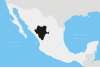
Nuevo León is a state in Mexico. The state was named after the New Kingdom of León, an administrative territory from the Viceroyalty of New Spain, itself was named after the historic Spanish Kingdom of León. With a total land area of 64,555 square kilometers, Nuevo León is the 13th largest federal entity in Mexico. The state is located in the northeastern part of Mexico and is bordered by Tamaulipas to the east, Coahuila to the west, and both Zacatecas and San Luis Potosi to the south. To the north, it shares an extremely narrow international border with the U.S. state of Texas. The Laredo-Colombia Solidarity International Bridge is the only vehicular bridge that connects the United States with the state of Nuevo León. It crosses over the Rio Grande between the city of Colombia, Nuevo León, and Laredo, Texas.

Guadalupe is a city and surrounding municipality located in the state of Nuevo León, in northern Mexico. It is part of the Greater Monterrey Metropolitan area.

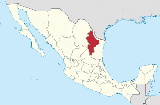
Linares is a small city in the state of Nuevo León, Mexico. The city serves as the administrative centre for the surrounding municipality of the same name and it is the largest urban centre of the so-called "orange belt" region. The city had a 2005 census population of 56,065, while the municipality's population was 71,061. The city and the municipality both rank tenth in population in the state. The municipality has an area of 2,445.2 km² and lies in the east-southeast part of the state on the border with the state of Tamaulipas. The municipality of Hualahuises is an enclave of Linares municipality.

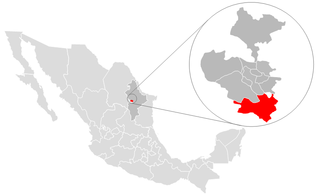
Apodaca is a city and its surrounding municipality that is part of Monterrey Metropolitan area. It lies in the northeastern part of the Monterrey Metropolitan Area. It is known for becoming recently a heavy industrialized city. As of 2019, the city houses 70% of the industrial plants of the state of Nuevo León. Apodaca is as well the fourth most exporting city in México. The municipality has an area of 224.7 km2. The population has recently increased from around 115,000 people in 1990 to almost 600,000 in 2015. Being one of the fastest-growing territories in terms of population in the Metropolitan Area, becoming the third most populous municipality as of 2015. The municipality is home to Monterrey International Airport which is considered to be the fourth most important in the country and is also one of the municipalities main employers.

Cristianópolis is a municipality in south-eastern Goiás state, Brazil.
Camargo is a municipality in the Mexican state of Tamaulipas. It is located on the US border, across from Rio Grande City, Texas. It has an official population of 14,933 inhabitants. The municipal seat is Ciudad Camargo, with a population of 7,984. The municipality is connected to Rio Grande City, Texas, via the Rio Grande City-Camargo International Bridge.
Santiago is a municipality and city located in the center of the Mexican state of Nuevo León. It is part of the Monterrey metropolitan area and its area comprises around 739.2 km². According to the 2005 census, it had a population of 37,886.
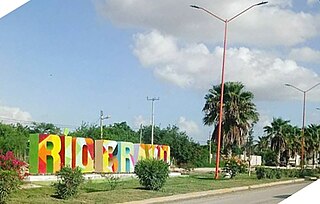
Río Bravo, formally Ciudad Río Bravo, is a city on the northern border of the state of Tamaulipas in northeastern Mexico.

García is a city and municipality located to the northwest of the Monterrey metropolitan area in the state of Nuevo León, Mexico. The municipality had, according to the 2005 census, a population of 145,867. It borders the municipalities of Mina, Escobedo and Hidalgo to the north; to the south and east with Santa Catarina; and to the west with the state of Coahuila.

Las Margaritas is a city, and the surrounding municipality of the same name, in the Mexican state of Chiapas. The municipal seat is located some 25 km to the northeast of Comitán de Domínguez, while the municipality extends to the east as far as the border with Guatemala. Part of the Lagunas de Montebello National Park is in the municipality's territory.

According to a 2022 census, there were 74,122 Mennonites living in Mexico, the vast majority of which are established in the state of Chihuahua, followed by Campeche at around 15,000, with the rest living in smaller colonies in the states of Durango, Tamaulipas, Zacatecas, San Luis Potosí and Quintana Roo.

Villaflores Municipality is a municipality in the Mexican state of Chiapas in southern Mexico, and the name of its largest settlement and seat of the municipal government. Situated in the Sierra Madre de Chiapas range, the municipality has an area of approximately 1232 km2 at an average elevation of 540m above mean sea level.

Huixtla is a town and municipality in the Mexican state of Chiapas in southern Mexico.

Pichucalco is a town and municipality in the Mexican state of Chiapas in southern Mexico.

Pueblo Nuevo Solistahuacán is a town and municipality in the Mexican state of Chiapas in southern Mexico.

Villa Corzo is a city and municipality in the Mexican state of Chiapas in southern Mexico. The city of Villa Corzo (the municipal seat is located at

Nuevo Casas Grandes is a Mexican municipality, located in the state of Chihuahua, northwestern Mexico. The capital and seat of the municipality is the city of Nuevo Casas Grandes, which has the same name as the surrounding municipality.

Canatlán is one of the 39 municipalities of Durango, in northwestern Mexico. The municipal seat lies at Ciudad Canatlán. The municipality covers an area of 468643.1 km2.
Nuevo Ideal is a city in the Mexican state of Durango. In the 1920s, a population of Mennonite immigrants, originating from Canada, settled in the area. As of 2020, Nuevo Ideal had a population of 12,850. The city is located on the eastern slopes of the Sierra Madre Occidental.

Acala is a municipality in the Mexican state of Chiapas, in southern Mexico. The municipal seat is Acala.