Santiago Papasquiaro | |
|---|---|
Municipal Seat and city | |
 Coat of arms | |
 Santiago Papasquiaro  Santiago Papasquiaro | |
| Coordinates: 25°02′38″N105°25′09″W / 25.04389°N 105.41917°W | |
| Country | |
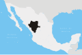
| State | Durango |
| Municipality | Santiago Papasquiaro |
| Area | |
• Total | 7,238 km2 (2,795 sq mi) |
| Elevation | 1,750 m (5,740 ft) |
| Population (2015) | |
• Total | 26,121 |
| Time zone | UTC-6 (Central) |
| Postal code | 34630 |
| Area code | 674 |
Santiago Papasquiaro is a city located in a valley situated on the eastern slopes of the Sierra Madre Occidental in the Mexican state of Durango. As of 2010, the city of Santiago Papasquiaro had a population of 26,121, [1] while the municipality has a census population of 48,482 as of 2015. [2] It is the fourth largest community in the state in terms of population, and is the municipal seat of the municipality of the same name. The municipality has an area of 7,238.4 km2 (2,794.8 sq mi).
Contents
During the past few years, the city's infrastructure has improved vastly. Agriculture is a vital part of the city's economy. Santiago Papasquiaro is also the home of Mexican Army's 71st Infantry Battalion barracks.