Lerdo, Durango

Last updated
Lerdo, Durango
Ciudad Lerdo
Plaza de armas de lerdo.JPG
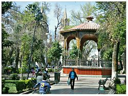
Plaza de Armas of Lerdo
Nickname(s): 
garden city
Mexico Durango location map.svg
Red pog.svg
Lerdo, Durango
Location in Mexico
Mexico States blank map.svg
Red pog.svg
Lerdo, Durango
Lerdo, Durango (Mexico)
Coordinates: 25°33′N103°31′W / 25.550°N 103.517°W / 25.550; -103.517 Coordinates: 25°33′N103°31′W / 25.550°N 103.517°W / 25.550; -103.517
CountryFlag of Mexico.svg  Mexico
State Durango
MunicipalityLerdo
Government
  Presidente MunicipalCarlos Aguilera Andrade
Elevation
1,130 m (3,710 ft)
Population
 (2010)
  Total79,669
Website Lerdo.gob.mx

Ciudad Lerdo (Lerdo City) is a small city in the northeastern portion of the Mexican state of Durango. It serves as the municipal seat for the surrounding municipality of the same name.

Contents

It is located at co-ordinates 25.33° N, 103.31° W, bordering southeastern Coahuila. As of 2010, the city of Lerdo had a population of 79,669, [1] up from 71,373 people as of 2005. Lerdo Municipality had a population of 141,043. [1] The municipality has an area of 1,868.8 km² (721.5 sq mi). It is part of a greater metropolitan area that includes Torreón Municipality and Matamoros Municipality in Coahuila, as well as Gómez Palacio Municipality in Durango.

The city is lush with vegetation, but has an arid climate. Ciudad Lerdo is known for its parks, gardens, and ice cream made with fresh milk from local dairies.

Notable people

Sister cities

City nursery Vivero de lerdo.JPG
City nursery

Ciudad Lerdo has one sister city, as designated by Sister Cities International:

Related Research Articles

Coahuila State of Mexico

Coahuila, formally Coahuila de Zaragoza, officially the Free and Sovereign State of Coahuila de Zaragoza, is one of the 32 states of Mexico.

Piedras Negras, Coahuila City in Coahuila, Mexico

Piedras Negras is a city and seat of the surrounding municipality of the same name in the Mexican state of Coahuila. It stands at the northeastern edge of Coahuila on the Mexico–United States border, across the Rio Grande from Eagle Pass in the U.S. state of Texas. In the 2015 census the city had a population of 163,595 inhabitants, while the metropolitan area had a population of 245,155 inhabitants. The Piedras Negras and the Eagle Pass areas are connected by the Eagle Pass–Piedras Negras International Bridge, Camino Real International Bridge, and the Union Pacific International Railroad Bridge.

Torreón City in Coahuila, Mexico

Torreón is a city and seat of Torreón Municipality in the Mexican state of Coahuila. As of 2021, the city's population was 735,340. The metropolitan population as of 2015 was 1,497,734, making it the ninth-biggest metropolitan area in the country and the largest metropolitan area in the state of Coahuila, as well as one of Mexico's most important economic and industrial centers. The cities of Torreón, Gómez Palacio, Durango, Lerdo, Durango as well as Matamoros, Francisco I. Madero, San Pedro, Bermejillo, Durango and Tlahualilo, Durango form the area of La Laguna or the Comarca Lagunera, a basin within the Chihuahuan Desert.

Durango State of Mexico

Durango, officially named Free and Sovereign State of Durango, is one of the 31 states which make up the 32 Federal Entities of Mexico, situated in the northwest of the country. With a population of 1,832,650, Durango has Mexico's second-lowest population density, after Baja California Sur. The capital city, Victoria de Durango, is named after the first president of Mexico, Guadalupe Victoria.

Durango City City in Durango, Mexico

Durango City, officially Victoria de Durango is the capital and largest city of the Mexican state of Durango. The city, which is located in Northern Mexico has a population of 654,876 as of the 2015 census, and sits at an altitude of 1,890 metres. It is also the municipal seat of the Durango Municipality. The city's official name is Victoria de Durango. The denomination of Victoria was added in honor of the first president of Mexico, Guadalupe Victoria, who was originally from the state of Durango. In the Tepehuán language, the city is known as Korian.

Gómez Palacio, Durango City in Durango, Mexico

Gómez Palacio is a city and its surrounding municipality in northeastern Durango, Mexico, adjacent to the border of the state of Coahuila. The city is named in honor of former Durango governor, Francisco Gómez Palacio y Bravo.

Ciudad Acuña City in Coahuila, Mexico

Ciudad Acuña, also known simply as Acuña, is a city located in the Mexican state of Coahuila, at 29°19′27″N100°55′54″W and a mean height above sea level of 271 m (889 ft). It stands on the Rio Grande, which marks the U.S.-Mexico border, and offers two border crossings via Lake Amistad Dam International Crossing and Del Río-Ciudad Acuña International Bridge with the neighboring city of Del Rio in the U.S. state of Texas. It serves as the municipal seat of the surrounding municipality of Acuña. The 2017 estimated city population was 201,778, whereas the municipality's population was 214,616. The city is the fourth-largest in the state of Coahuila and the fastest-growing city in Mexico. The area is served by the Ciudad Acuña International Airport.

Comarca Lagunera Place in Mexico

The Comarca Lagunera or La Comarca de la Laguna is a region of northern Mexico occupying large portions of the states of Durango and Coahuila, with rich soils produced by periodic flooding of the Nazas and Aguanaval rivers. Neither river drains into either the Pacific Ocean or the Gulf of Mexico, but rather they created a series of inland lakes. The region was developed for large-scale irrigated cotton agriculture. During the Mexican Revolution, the region was the site of fierce fighting. Following the military phase of the Revolution, the region was part of the agrarian reform under President Lázaro Cárdenas. The dam named for Cárdenas now controls flooding of the rivers, but the groundwater resources are no longer recharged as a result. It is the 8th largest metropolitan area in Mexico.

The metropolitan areas of Mexico have been traditionally defined as the group of municipalities that heavily interact with each other, usually around a core city. The phenomenon of metropolization in Mexico is relatively recent, starting in the 1940's, and due to the accelerated level of urbanization in the country, the definition of a metropolitan area is reviewed periodically by the Mexican population and census authorities.

Cuencamé Place in Durango, Mexico

Cuencamé is a small city and the seat of the municipality of Cuencamé in the state of Durango, which is in northern Mexico. As of 2015, the city had a total population of 9,848.

Matamoros, Coahuila Municipal seat in Coahuila, Mexico

Matamoros is a city and seat of the Matamoros Municipality located in the southwestern part of the state of Coahuila in Mexico. It lies directly east of the larger city of Torreón, and is a part of Comarca Lagunera, a larger metropolitan area, that includes Torreón Municipality in Coahuila in addition to Gómez Palacio Municipality and Lerdo Municipality in the adjacent state of Durango.

Tlahualilo de Zaragoza Municipal seat and city in Durango, Mexico

Tlahualilo de Zaragoza is a city located in the northeastern part of the Mexican state of Durango. Tlahualilo of Zaragoza is the municipal seat of the Tlahualilo municipio. As of 2010, the city had a population of 9,517. The city is part of the Comarca Lagunera metropolitan area, which has a population totalling more than 912,000 inhabitants in 2005. The municipality has a population of 22,244 and borders the state of Coahuila in the east, the municipality of Mapimí to the west and the city of Gómez Palacio to the south.

Acuña Municipality Municipality in Coahuila, Mexico

Acuña is one of the 38 municipalities of Coahuila, in north-eastern Mexico. The municipal seat lies at Ciudad Acuña, which contained over 98% of the municipality's population in 2010. The municipality covers an area of 11,487.7 km² and is located on the international border between Mexico and the USA, here formed by the Río Bravo del Norte, adjacent to the U.S. state of Texas.

Cuencamé Municipality Municipality in Durango, Mexico

Cuencamé is one of the 39 municipalities of Durango, in north-western Mexico. In 2015, the municipality had a total population of 35,415.The municipal seat lies at Cuencamé de Ceniceros. The municipality covers an area of 1324.9 km².

Mapimí Municipality Municipality in Durango, Mexico

Mapimí is one of the 39 municipalities of Durango, in north-western Mexico. The municipal seat lies at Mapimí. The municipality covers an area of 7,126.7 km².

Durango Municipality Municipality in Durango, Mexico

Durango is one of the 39 municipalities of Durango, in north-western Mexico. The municipal seat lies at Durango. The municipality covers an area of 10,041 km².

Lerdo Municipality Municipality in Durango, Mexico

Lerdo is one of the 39 municipalities of Durango, in north-western Mexico. The municipal seat lies at Ciudad Lerdo. The municipality covers an area of 1868.8 km².

Chihuahua (state) State of Mexico

Chihuahua, officially the Free and Sovereign State of Chihuahua, is one of the 32 states which comprise the 32 Federal Entities of Mexico. It is located in northwestern Mexico, and is bordered by the states of Sonora to the west, Sinaloa to the southwest, Durango to the south, and Coahuila to the east. To the north and northeast, it shares an extensive border with the U.S. adjacent to the U.S. states of New Mexico and Texas. Its capital city is Chihuahua City.

Cañon de Fernandez State Park is a natural protected area in the northern Mexican state of Durango. It covers 17,000 hectares straddling the Nazas River in Lerdo Municipality, right in the middle of the Chihuahuan Desert. It was protected by the government of Durango in 2004 and it was named a Ramsar wetland in 2008, the only Ramsar site in Durango and the second in the Chihuahuan Desert after Cuatrocienegas, Coahuila.

The Lalá Marathon is a 26.2-mile footrace from Gómez Palacio to Torreón, Mexico, first held in 1989. The marathon runs through Torreón's metro area, which is known as "La Laguna," and crosses through the states of Coahuila and Durango. In 2011, Kenyan Hillary Kipchirchir Kimaiyo set a record for the fastest marathon ever run in Mexico when he ran a 2:08:17.

References

  1. 1 2 "Lerdo". Catálogo de Localidades. Secretaría de Desarrollo Social (SEDESOL). Retrieved 23 April 2014.