O'Sullivan Peak (Utah)

Last updated
O'Sullivan Peak
Sunrise Peak
O'Sullivan Peak.jpg
North aspect
Highest point
Elevation 11,275 ft (3,437 m) [1] [2]
Prominence 495 ft (151 m) [2]
Parent peak Broads Fork Twin Peaks [2]
Isolation 0.53 mi (0.85 km) [2]
Coordinates 40°35′27″N111°42′40″W / 40.5909068°N 111.7111983°W / 40.5909068; -111.7111983 [3]
Naming
Etymology Timothy H. O'Sullivan
Geography
USA Utah relief location map.svg
Red triangle with thick white border.svg
O'Sullivan Peak
Location in Utah
Usa edcp relief location map.png
Red triangle with thick white border.svg
O'Sullivan Peak
O'Sullivan Peak (the United States)
CountryUnited States
State Utah
County Salt Lake
Protected area Twin Peaks Wilderness [4]
Parent range Wasatch Range
Rocky Mountains
Topo map USGS Dromedary Peak
Climbing
Easiest route class 3+ scrambling [2]

O'Sullivan Peak, also known as Sunrise Peak, is an 11,275-foot-elevation (3,437-meter) mountain summit located in Salt Lake County, Utah, United States.

Contents

Description

O'Sullivan Peak is located 15 miles (24 km) southeast of downtown Salt Lake City in the Twin Peaks Wilderness on land managed by Wasatch–Cache National Forest. [4] The peak is set in the Wasatch Range which is a subset of the Rocky Mountains. Precipitation runoff from the mountain's south slope drains to Little Cottonwood Creek, whereas the north slope drains to Big Cottonwood Creek, and both creeks flow west to the Jordan River. Topographic relief is significant as the summit rises 4,475 feet (1,364 meters) above Little Cottonwood Canyon in 1.4 mile (2.25 km). This mountain's toponym was officially adopted in 1978 by the United States Board on Geographic Names to remember Timothy H. O'Sullivan (1840–1882), civil war and western frontier photographer who visited this area as the official photographer of the King Survey and Wheeler Survey. [1]

Related Research Articles

<span class="mw-page-title-main">Wasatch Range</span> Sub-range of the Rocky Mountains in the western United States

The Wasatch Range or Wasatch Mountains is a mountain range in the western United States that runs about 160 miles (260 km) from the Utah-Idaho border south to central Utah. It is the western edge of the greater Rocky Mountains, and the eastern edge of the Great Basin region. The northern extension of the Wasatch Range, the Bear River Mountains, extends just into Idaho, constituting all of the Wasatch Range in that state.

<span class="mw-page-title-main">Mount Superior</span> Mountain in the American state of Utah

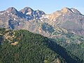
Mount Superior is an 11,045 feet (3,367 m) mountain peak in the Uinta-Wasatch-Cache National Forest in Salt Lake County, Utah, United States.

<span class="mw-page-title-main">Dead Horse Peak</span> Mountain in the American state of Utah

Dead Horse Peak is a 12,642-foot elevation (3,853 m) mountain summit located on the common border that Duchesne County shares with Summit County in the U.S. state of Utah.

<span class="mw-page-title-main">Yard Peak</span> Mountain in the American state of Utah

Yard Peak is a 12,706-foot elevation (3,873 m) mountain summit located on the common border that Duchesne County shares with Summit County in the U.S. state of Utah.

<span class="mw-page-title-main">Mount Raymond (Utah)</span> Mountain summit located in Salt Lake County, Utah, US

Mount Raymond is a 10,241-foot elevation (3,121 m) mountain summit located in Salt Lake County, Utah, United States.

<span class="mw-page-title-main">Gobblers Knob (Utah)</span> Mountain in the American state of Utah

Gobblers Knob is a 10,246-foot elevation (3,123 m) mountain summit located in Salt Lake County, Utah, United States.

<span class="mw-page-title-main">Kesler Peak (Wasatch Range)</span> Mountain in the American state of Utah

Kesler Peak is a 10,403-foot elevation (3,171 m) mountain summit located in Salt Lake County, Utah, United States.

<span class="mw-page-title-main">Willard Peak</span> Mountain in the American state of Utah

Willard Peak is a 9,763-foot elevation (2,976 m) mountain summit located on the common border Box Elder County shares with Weber County in Utah, United States.

<span class="mw-page-title-main">Spanish Fork Peak</span> Mountain peak in Utah County, United States

Spanish Fork Peak is a 10,192-foot elevation (3,107 m) mountain summit located in Utah County, Utah, United States.

<span class="mw-page-title-main">Grandeur Peak</span>

Grandeur Peak is an 8,299-foot-elevation (2,530-meter) mountain summit located in Salt Lake County, Utah, United States.

<span class="mw-page-title-main">Mount Aire</span>

Mount Aire is an 8,621-foot-elevation (2,628-meter) mountain summit located in Salt Lake County, Utah, United States.

<span class="mw-page-title-main">Box Elder Peak (Utah County, Utah)</span>

Box Elder Peak is an 11,101-foot-elevation (3,384-meter) mountain summit located in Utah County, Utah, United States.

<span class="mw-page-title-main">Sugarloaf Mountain (Utah)</span>

Sugarloaf Mountain is an 11,051-foot-elevation (3,368-meter) summit on the boundary that Salt Lake County shares with Utah County, in Utah, United States.

<span class="mw-page-title-main">Mount Baldy (Salt Lake County, Utah)</span>

Mount Baldy is an 11,068-foot-elevation (3,374-meter) summit on the boundary that Salt Lake County shares with Utah County, in Utah, United States.

<span class="mw-page-title-main">Clayton Peak</span> Mountain in Utah, United States

Clayton Peak, also known unofficially as Mount Majestic, is a 10,721-foot-elevation (3,268-meter) summit on the boundary that Salt Lake County shares with Wasatch County, in Utah, United States.

<span class="mw-page-title-main">Mount Millicent</span>

Mount Millicent is a 10,452-foot-elevation (3,186-meter) summit in Salt Lake County, Utah, United States.

<span class="mw-page-title-main">Mount Wolverine</span>

Mount Wolverine is a 10,795-foot-elevation (3,290-meter) summit in Salt Lake County, Utah, United States.

<span class="mw-page-title-main">Sunset Peak (Utah)</span>

Sunset Peak is a 10,648-foot-elevation (3,246-meter) summit in Utah, United States.

<span class="mw-page-title-main">Dromedary Peak</span>

Dromedary Peak is an 11,107-foot-elevation (3,385-meter) mountain summit located in Salt Lake County, Utah, United States.

<span class="mw-page-title-main">Mount Tuscarora (Utah)</span>

Mount Tuscarora is a 10,646-foot-elevation (3,245-meter) summit in Salt Lake County, Utah, United States.

References

  1. 1 2 United States Board on Geographic Names, Decisions on Geographic Names in the United States, Decision List No. 7803, 1978, p. 25.
  2. 1 2 3 4 5 "O'Sullivan Peak - 11,275' UT". listsofjohn.com. Retrieved 2024-05-31.
  3. "O'Sullivan Peak". Geographic Names Information System . United States Geological Survey, United States Department of the Interior . Retrieved 2024-05-31.
  4. 1 2 "Sunrise Peak, Utah". Peakbagger.com. Retrieved 2024-05-31.