Observation Peak (California)

Last updated
Observation Peak
Observation Peak, Dumbbell Lake.jpg
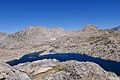
South aspect, from Dumbbell Lakes
Highest point
Elevation 12,362 ft (3,768 m) [1] [2]
Prominence 802 ft (244 m) [2]
Isolation 1.61 mi (2.59 km) [3]
Listing Sierra Peaks Section
Coordinates 37°01′24″N118°31′25″W / 37.0232152°N 118.5236653°W / 37.0232152; -118.5236653 [4]
Geography
Relief map of California.png
Red triangle with thick white border.svg
Observation Peak
Location in California
Usa edcp relief location map.png
Red triangle with thick white border.svg
Observation Peak
Observation Peak (the United States)
Location Kings Canyon National Park
Fresno County, California, U.S.
Parent range Sierra Nevada
Topo map USGS North Palisade
Geology
Type of rock granitic
Climbing
First ascent 1902 Joseph Nisbet LeConte
Easiest route class 2 [3] via Dumbbell Lakes

Observation Peak is a 12,362-foot-elevation (3,768 meter) summit located in Fresno County, California, United States. [4]

Contents

Description

The mountain is set five miles west of the crest of the Sierra Nevada mountain range, in the Palisades area of Kings Canyon National Park. It is situated 4.4 miles (7.1 km) southwest of Middle Palisade, and one mile south-southeast of Mount Shakspere. Observation Peak ranks as the 323rd-highest summit in California, [3] and topographic relief is significant as the summit rises 2,400 feet (730 meters) above Cataract Creek in approximately one mile. Precipitation runoff from this mountain drains into tributaries of the Middle Fork Kings River.

History

The first ascent of the summit was made July 25, 1902, by Joseph Nisbet LeConte and Curtis W. Lindley via Dumbbell Lakes. [5] LeConte so named the peak because he used the summit as a triangulation base for mapping the area. [6] [7] This mountain's toponym has been officially adopted by the United States Board on Geographic Names. [4]

Climate

Observation Peak is located in an alpine climate zone. [8] Most weather fronts originate in the Pacific Ocean, and travel east toward the Sierra Nevada mountains. As fronts approach, they are forced upward by the peaks (orographic lift), causing them to drop their moisture in the form of rain or snowfall onto the range.

See also

Related Research Articles

<span class="mw-page-title-main">Mount Sill</span> Mountain of the Sierra Nevada in California, United States

Mount Sill is one of the fourteeners of the Sierra Nevada in California. It is located in the Palisades, a group of prominent rock peaks with a few small glaciers on their flanks. Mount Sill is located 0.6 miles (1 km) east of North Palisade, the high point of the group. The two peaks are connected by a high, rocky ridge, on the north side of which lies the Palisade Glacier. Mount Sill lies on the main Sierra Crest, but is at a point where the crest turns sharply, giving it particularly striking summit views. On one side is Kings Canyon National Park and Fresno County; on the other is the John Muir Wilderness, Inyo National Forest and Inyo County.

<span class="mw-page-title-main">Black Giant</span> Mountain in the state of California

Black Giant is a 13,330-foot-elevation (4,060-meter) mountain summit located west of the crest of the Sierra Nevada mountain range, in Fresno County of central California, United States. Black Giant ranks as the 86th highest summit in California. It is the northernmost and highest summit on its namesake ridge, the Black Divide in northern Kings Canyon National Park. The peak is situated 3.9 miles (6.3 km) east of Mount Goddard, and 2.6 miles (4.2 km) south-southeast of Mount Fiske, which is the nearest higher neighbor. Topographic relief is significant as it rises 4,000 feet above Le Conte Canyon in approximately two miles. Muir Pass is 1.4 miles (2.3 km) to the northwest, and the approach to this remote peak is made via the John Muir Trail.

<span class="mw-page-title-main">Picture Puzzle</span> Mountain peak of the Sierra Nevada in California, United States

Picture Puzzle, also known as Picture Puzzle Peak, is a 13,297-foot-elevation mountain summit located one mile east of the crest of the Sierra Nevada mountain range in Inyo County of northern California, United States. It is situated in the Palisades area of the John Muir Wilderness, on land managed by Inyo National Forest. It is approximately 14.5 miles (23.3 km) west of the community of Big Pine, one mile north of Bishop Pass, 0.8 miles (1.3 km) northwest of Aperture Peak, 1.2 miles (1.9 km) north-northwest of Mount Agassiz, and 1.1 miles (1.8 km) south-southwest of parent Cloudripper. Picture Puzzle ranks as the 90th-highest summit in California, and the third-highest peak of the Inconsolable Range.

<span class="mw-page-title-main">Marion Peak</span> Mountain in the state of California

Marion Peak is a remote 12,719-foot-elevation (3,877-meter) mountain summit located in Kings Canyon National Park, in Fresno County of northern California, United States. It is situated on Cirque Crest which is west of the crest of the Sierra Nevada mountain range, 2.13 miles (3.43 km) northeast of State Peak, and 2.6 miles (4.2 km) northwest of Arrow Peak, the nearest higher neighbor. Topographic relief is significant as the north aspect rises 2,400 feet above Marion Lake in one mile, and the southeast aspect rises 3,500 feet above South Fork Kings River in less than two miles.

<span class="mw-page-title-main">Mount Bago</span>

Mount Bago is an 11,870-foot-elevation (3,620-meter) mountain summit located west of the crest of the Sierra Nevada mountain range, in the southeast corner of Fresno County, in northern California. It is situated in Kings Canyon National Park, 14 miles (23 km) west of the community of Independence, 2.3 miles west of the Kearsarge Pinnacles, and 2.4 miles southwest of Mount Rixford. Topographic relief is significant as the south aspect rises 3,675 feet above Junction Meadow in one mile. The John Muir Trail passes to the northeast of this remote geographical feature. The first ascent of the summit was made July 11, 1896, by Joseph Nisbet LeConte and Wilson S. Gould.

<span class="mw-page-title-main">The Sphinx (Kings Canyon National Park)</span>

The Sphinx is a 9,143-foot-elevation (2,787-meter) double summit granitic pillar located west of the crest of the Sierra Nevada mountain range, in Kings Canyon National Park, in Fresno County of northern California. This landmark is situated at the northern end of the Great Western Divide, two miles southeast of Kanawyers, five miles northwest of North Guard, and immediately south of the confluence of Bubbs Creek and South Fork Kings River. Topographic relief is significant as the north aspect rises 4,000 feet above the canyon in one mile. This geographical feature was named in 1891 by John Muir. This feature's name has been officially adopted by the United States Board on Geographic Names. The Sphinx formation is the further north and slightly lower of the two peaks, and was the first rock climb done in the Kings Canyon region. The first ascent of the summit was made July 26, 1940, by Art Argiewicz and Bob Jacobs. The North Buttress was first climbed October 18, 1970, by Fred Beckey, Greg Donaldson, and Walt Vennum.

<span class="mw-page-title-main">Mount McDuffie</span> Mountain in the state of California

Mount McDuffie is a 13,291-foot-elevation (4,051-meter) mountain summit located west of the crest of the Sierra Nevada mountain range, in Fresno County of central California, United States. This peak is situated in northern Kings Canyon National Park, 1.9 miles (3.1 km) northwest of The Citadel, and two miles south of Black Giant, which is the nearest higher neighbor. McDuffie ranks as the 93rd highest summit in California, and the second-highest point on Black Divide. Topographic relief is significant as it rises nearly 4,900 feet above Le Conte Canyon in approximately 2.5 miles. An approach to this remote peak is made possible via the John Muir Trail.

<span class="mw-page-title-main">Giraud Peak</span>

Giraud Peak is a 12,608-foot-elevation (3,843-meter) mountain summit located west of the crest of the Sierra Nevada mountain range, in Fresno County of northern California, United States. It is situated in the Palisades area of northern Kings Canyon National Park, 3.0 miles (4.8 km) southwest of North Palisade, and 1.5 miles (2.4 km) southwest of Columbine Peak, the nearest higher neighbor. Giraud Peak ranks as the 258th-highest summit in California. Topographic relief is significant as the west aspect rises 4,400 feet above LeConte Canyon in less than two miles. On the direct opposite side of the canyon The Citadel stands guard. The first ascent of the summit was made September 1, 1925, by Norman Clyde via the east arête.

<span class="mw-page-title-main">The Thumb (California)</span>

The Thumb is a 13,356-foot-elevation (4,071-meter) mountain summit located on the crest of the Sierra Nevada mountain range, in Inyo County of northern California. It is situated in the Palisades area of the John Muir Wilderness, on land managed by Inyo National Forest. It is 1.3 miles (2.1 km) east of Middle Palisade, 1.6 miles (2.6 km) west-northwest of Birch Mountain, and 1.8 miles (2.9 km) north of Mount Bolton Brown. The Thumb ranks as the 83rd-highest summit in California. Topographic relief is significant as the east aspect rises over 2,500 feet above Birch Lake in approximately one mile. The John Muir Trail traverses below the southwest aspect of the mountain, providing an optional approach access.

<span class="mw-page-title-main">Wheel Mountain</span> Mountain in the state of California

Wheel Mountain is a 12,774-foot-elevation (3,894-meter) mountain summit located west of the crest of the Sierra Nevada mountain range, in Fresno County of central California, United States. This mountain is situated on the Black Divide in northern Kings Canyon National Park, one mile northwest of Devils Crags, and two miles south-southeast of Mount McDuffie, which is the nearest higher neighbor. Wheel Mountain ranks as the 216th-highest summit in California, and the fifth-highest on Black Divide. Topographic relief is significant as the west aspect rises 4,500 feet above Enchanted Gorge in approximately 1.5 mile, and the east aspect rises 4,500 feet above Le Conte Canyon in 2.5 miles. An approach to this remote peak is made possible via the John Muir Trail.

<span class="mw-page-title-main">Mount Gilbert (California)</span> Mountain in California, United States

Mount Gilbert is a 13,106-foot (3,995 m) mountain located on the crest of the Sierra Nevada range in California, United States. It is situated on the shared boundary of Kings Canyon National Park and John Muir Wilderness, and along the common border of Fresno County and Inyo County. It is 18 miles (29 km) west of the community of Big Pine, 0.8 mile northwest of Mount Johnson, and one mile southeast of Mount Thompson, which is its nearest higher neighbor. Mount Gilbert ranks as the 127th-highest summit in California. Topographic relief is significant as the south aspect rises 3,900 feet (1,189 m) above LeConte Canyon in less than two miles, and the northern aspect rises 3,340 feet above South Lake in 2.5 miles.

<span class="mw-page-title-main">Mount Johnson (California)</span> Mountain in the state of California

Mount Johnson is a 12,871-foot-elevation mountain summit located on the crest of the Sierra Nevada mountain range in California, United States. It is situated on the boundary between Kings Canyon National Park and John Muir Wilderness, and along the county line between Fresno County and Inyo County. It is also 18 miles (29 km) west of the community of Big Pine, 0.9 miles (1.4 km) southeast of Mount Gilbert, and one mile (1.6 km) west-northwest of Mount Goode. Mount Johnson ranks as the 187th-highest summit in California. Topographic relief is significant as the southwest aspect rises 3,670 feet above LeConte Canyon in 1.5 mile, and the north aspect rises 3,100 feet above South Lake in 2.5 miles.

<span class="mw-page-title-main">Mount Shakspere</span> Mountain in the state of California

Mount Shakspere is a 12,174-foot-elevation summit located in Fresno County, California, United States.

<span class="mw-page-title-main">Disappointment Peak (California)</span> Mountain in the state of California

Disappointment Peak is a 13,917-foot-elevation summit located on the shared boundary of Fresno County and Inyo County in California, United States.

<span class="mw-page-title-main">Mount Bolton Brown</span> Mountain in the state of California

Mount Bolton Brown is a 13,491-foot-elevation (4,112 meter) mountain summit located on the shared border of Fresno County and Inyo County in California, United States.

<span class="mw-page-title-main">Mount Prater</span> Mountain in the state of California

Mount Prater is a 13,471-foot-elevation (4,106 meter) mountain summit located on the shared border of Fresno County and Inyo County in California, United States.

<span class="mw-page-title-main">Mount Reinstein</span> Mountain in California, United States of America

Mount Reinstein is a 12,586-foot-elevation (3,836 meter) mountain summit located west of the crest of the Sierra Nevada mountain range, in Fresno County, California, United States. This peak is situated on the common boundary shared by Kings Canyon National Park with John Muir Wilderness, and it is the highest point on LeConte Divide. Reinstein ranks as the 260th-highest summit in California. It is set 2.7 miles (4.3 km) west of Scylla and 2.0 miles (3.2 km) southwest of Mount Goddard. Topographic relief is significant as the summit rises nearly 1,600 feet above Martha Lake in less than one mile. An ascent of the peak is non-technical, and inclusion on the Sierra Peaks Section peakbagging list generates climbing interest in this remote peak.

<span class="mw-page-title-main">Mount Jepson</span> Mountain in the state of California

Mount Jepson is a 13,390-foot-elevation (4,081 meter) summit located on the shared boundary of Fresno County and Inyo County in California, United States.

<span class="mw-page-title-main">Aperture Peak</span> Mountain in the state of California

Aperture Peak is a 13,265-foot-elevation mountain summit located in Inyo County, California, United States.

<span class="mw-page-title-main">Mount Robinson (California)</span> Mountain in the state of California

Mount Robinson is a 12,967-foot-elevation (3,952 meter) mountain summit located in Inyo County, California, United States.

References

  1. Peter Browning (1986), Place Names of the Sierra Nevada: From Abbot to Zumwalt, Wilderness Press, ISBN   9780899970479, p. 160
  2. 1 2 "Observation Peak, California". Peakbagger.com. Retrieved 2022-05-02.
  3. 1 2 3 "Observation Peak - 12,362' CA". listsofjohn.com. Retrieved 2022-05-02.
  4. 1 2 3 "Observation Peak". Geographic Names Information System . United States Geological Survey, United States Department of the Interior . Retrieved 2022-05-02.
  5. Hervey Voge and Fred L. Jones, A Climber's Guide to the High Sierra (1954)
  6. Francis Peloubet Farquhar (1926), Place Names of the High Sierra, Sierra Club (Publisher), p. 71
  7. Erwin G. Gudde, William Bright (2010), California Place Names: The Origin and Etymology of Current Geographical Names, University of California Press, ISBN   9780520266193, p. 267
  8. "Climate of the Sierra Nevada". Encyclopædia Britannica .