
Abbeville Municipal Airport is a city-owned, public-use airport located three nautical miles north of the central business district of Abbeville, a city in Henry County, Alabama, United States. It is the only airport that serves the city of Abbeville.
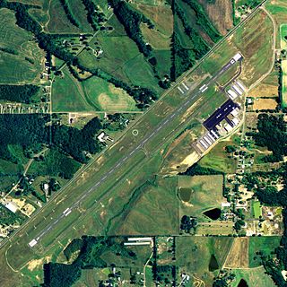
Albertville Regional Airport, also known as Thomas J. Brumlik Field, is a city-owned, public-use airport located three nautical miles southwest of the central business district of Albertville, in Marshall County, Alabama, United States. It was formerly known as Albertville Municipal Airport.

Camden Municipal Airport is a city-owned, public-use airport located three nautical miles (6 km) southwest of the central business district of Camden, a city in Wilcox County, Alabama, United States.

Centre Municipal Airport is a city-owned, public-use airport located three nautical miles east of the central business district of Centre, a city in Cherokee County, Alabama, United States. It is owned by the City of Centre.

Clayton Municipal Airport is a city-owned, public-use airport located two nautical miles west of the central business district of Clayton, a city in Barbour County, Alabama, United States.

Florala Municipal Airport is a city-owned public-use airport located three nautical miles northeast of the central business district of Florala, a city in Covington County, Alabama, United States.

Foley Municipal Airport is a city-owned public-use airport located three nautical miles northwest of the central business district of Foley, a city in Baldwin County, Alabama, United States.
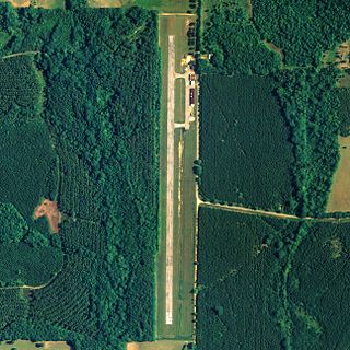
Greensboro Municipal Airport is a city-owned public-use airport located three nautical miles southwest of the central business district of Greensboro, a city in Hale County, Alabama, United States.

Headland Municipal Airport is a city-owned, public-use airport located two nautical miles northeast of the central business district of Headland, a city in Henry County, Alabama, United States.
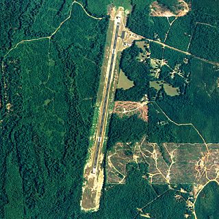
Jackson Municipal Airport is a city-owned public airport two miles south of Jackson, in Clarke County, Alabama.
Philadelphia Municipal Airport is a public use airport in Neshoba County, Mississippi, United States. It is owned by the City of Philadelphia and located two nautical miles (4 km) northwest of its central business district. This airport is included in the National Plan of Integrated Airport Systems for 2011–2015, which categorized it as a general aviation facility.

Charleston Municipal Airport is a city-owned, public-use airport located two nautical miles (4 km) south of the central business district of Charleston, a city in Tallahatchie County, Mississippi, United States. It is included in the National Plan of Integrated Airport Systems for 2011–2015, which categorized it as a general aviation facility.
Grant Municipal Airport is a city-owned, public-use airport located two nautical miles (4 km) north of the central business district of Grant, a city in Perkins County, Nebraska, United States. It is included in the National Plan of Integrated Airport Systems for 2011–2015, which categorized it as a general aviation airport.
Davenport Airport, also known as Davenport Municipal Airport, is a city-owned, public-use airport located one nautical mile (2 km) west of the central business district of Davenport, a city in Lincoln County, Washington, United States. It is included in the National Plan of Integrated Airport Systems for 2011–2015, which categorized it as a general aviation facility.
Pauls Valley Municipal Airport is a city-owned, public-use airport located two nautical miles (4 km) south of the central business district of Pauls Valley, a city in Garvin County, Oklahoma, United States. It is included in the National Plan of Integrated Airport Systems for 2011–2015, which categorized it as a general aviation facility.
Salem Municipal Airport is a city-owned, public-use airport located two nautical miles (4 km) west of the central business district of Salem, a city in Washington County, Indiana, United States. It is included in the National Plan of Integrated Airport Systems for 2011–2015, which categorized it as a general aviation facility.
Portland Municipal Airport is a city-owned, public-use airport located one nautical mile (2 km) northwest of the central business district of Portland, a city in Jay County, Indiana, United States. It is included in the National Plan of Integrated Airport Systems for 2011–2015, which categorized it as a general aviation facility.
Plymouth Municipal Airport is a public use airport located two nautical miles (4 km) north of the central business district of Plymouth, a city in Marshall County, Indiana, United States. It is owned by the Plymouth Board of Aviation of Commissioners. This airport is included in the National Plan of Integrated Airport Systems for 2011–2015, which categorized it as a general aviation facility.
Osceola Municipal Airport is a city-owned public-use airport located four nautical miles northeast of the central business district of Osceola, a city in Clarke County, Iowa, United States. It is included in the National Plan of Integrated Airport Systems for 2011–2015, which categorized it as a general aviation facility.

Marshall Memorial Municipal Airport is a city-owned, public-use airport located two nautical miles (4 km) south of the central business district of Marshall, a city in Saline County, Missouri, United States. It is included in the National Plan of Integrated Airport Systems for 2011–2015, which categorized it as a general aviation facility.


