
Gilroy is a city in Northern California's Santa Clara County, south of Morgan Hill and north of San Benito County. The city's population was 48,821 at the 2010 United States Census.

San Martin or San Martín is a census-designated place (CDP) in Santa Clara County, California, in the southern Santa Clara Valley, to the south of Morgan Hill and north of Gilroy, and in between the Santa Cruz Mountains to the west and the Diablo Range to the east.
Stirling City is an unincorporated community and census-designated place in Butte County, California, located on Paradise Ridge in the western foothills of the Sierra Nevada. Contrary to its name, Stirling City is not a city. Its ZIP Code is 95978 and area code 530. It lies at an elevation of 3570 feet. Stirling City had a population of 295 at the 2010 census.

The Coast Line is a railroad line between Burbank, California and the San Francisco Bay Area, roughly along the Pacific Coast. It is the shortest rail route from Los Angeles to the Bay Area.

Bell Station is an unincorporated community located along State Route 152 between Casa de Fruta and Pacheco Pass near the southeast extent of Santa Clara County, California.
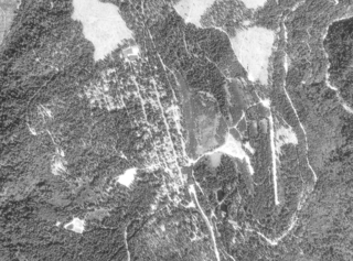
Rucker is a historic district in unincorporated community Santa Clara County, California located halfway along the five miles of Monterey Highway between Gilroy, California and San Martin. The name is official, but not in common use among locals today. Its elevation is listed as 235 feet above mean sea level (AMSL) and NAD27 coordinates are given as 37°03′15″N121°35′28″W. Supporting the name are local geographic features, Rucker Avenue, Rucker School (K-6), and Rucker Creek. The community was part of the Mexican land grant Rancho San Francisco de las Llagas.

KBAY is a classic hits radio station licensed to Gilroy, California, serving the San Francisco Bay Area and owned by Alpha Media, along with sister station KEZR. Its studios are located at Park Center Plaza in Downtown San Jose and the transmitter is based from a site in Santa Teresa County Park. KBAY switched to Christmas music every year from Thanksgiving through Christmas Day from approximately 2002 until 2018. The station competes with KUFX and KSAN. In 2016, KBAY switched on November 19, almost a week earlier than usual, in response to KOIT also switching earlier.
Sargent is an unincorporated community located at the Santa Clara-San Benito County border. The weight of the community is shown on the Santa Clara County, or north, side of the line. Like Rucker north of Gilroy, the name is official but not in active use by locals today. The U.S. Geological Survey lists a feature ID of 1656278 and an NAD27 latitude and longitude as 36°55′10″N121°32′49″W. It is shown as being 150 feet above mean sea level. It appeared on 1950s Thomas Brothers maps but has dropped off the company's 21st century maps.

Yawan District is one of the 28 districts of Badakhshan Province in eastern Afghanistan. It was created in 2005 from part of the Ragh District and is home to approximately 20,000 residents.
San Benito High School (SBHS) is a school in Hollister, California, United States. It serves as the primary high school for Hollister city residents and most county residents. The school's current enrollment is approximately 3,000 students, served by 250 faculty and staff.
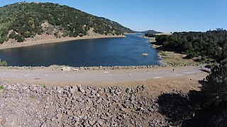
Coyote Dam is a 140-foot (43 m) high, 980-foot (300 m) long, earth and rock dam built in 1936 in Santa Clara County, California, United States, located north of Gilroy.
Gilroy High School is a co-educational public school located in Gilroy, California, that serves the city of Gilroy. It is one of two public comprehensive high schools in the city and has an approximate enrollment of 1,500 students.

Old Forbestown is an unincorporated community in Butte County, California. It lies at an elevation of 2861 feet.
Rancho San Ysidro was a 13,066-acre (52.88 km2) Spanish land grant in present day Santa Clara County, California, given in 1809 by Governor José Joaquín de Arrillaga to Ygnacio Ortega. Today's city of Gilroy is on former Rancho Ysidro lands, as is nearby Old Gilroy.

Edward F. Ricketts State Marine Conservation Area is one of four small marine protected areas located near the cities of Monterey and Pacific Grove, at the southern end of Monterey Bay on California’s central coast. The four areas together encompass 2.96 square miles (7.7 km2). Within SMCAs fishing and take of all living marine resources is prohibited except the recreational take of finfish by hook-and-line and the commercial take of giant and bull kelp under certain conditions.
Rancho Los Huecos was a 39,951-acre (161.68 km2) Mexican land grant in present-day Santa Clara County, California, given in 1846 by Governor Pio Pico to Luis Arenas and John A. Rowland. The grant extended along the San Felipe Valley between present day Gilroy and Hollister at the foot of the Diablo Range.
Dr. TJ Owens Gilroy Early College Academy is a prestigious early college high school located in Gilroy, California, at the southern edge of Silicon Valley, in the San Francisco Bay Area. A California Distinguished School, GECA regularly ranks among the top high schools in California and consistently ranks within the top 1% of the best high schools in the United States.
Christopher High School is a co-educational public school in Gilroy, California. It is one of two public comprehensive high schools in the city and has an approximate enrollment of 1,900 students. It is a part of the Gilroy Unified School District.
Lovejoy is an extinct town in Cape Girardeau County, in the U.S. state of Missouri. The GNIS classifies it as a populated place.
North Fork Pacheco Creek now regarded is a tributary stream of Pacheco Creek, in Santa Clara County, California. Originally it was considered the upper reach of Pacheco Creek. Its mouth is at its confluence with South Fork Pacheco Creek at an elevation of 430 feet / 131 meters where it forms the head of Pacheco Creek west of Pacheco Pass. Its source is at an elevation of 2,350 feet / 716 meters at 37°11′17″N121°25′42″W on a mountain side in Henry W. Coe State Park.


