Loyola, California

Last updated

Loyola
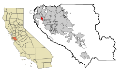
Santa Clara County California Incorporated and Unincorporated areas Loyola Highlighted.svg
Location in Santa Clara County and the state of California
Usa edcp location map.svg
Red pog.svg
Loyola
Location in the United States
Coordinates: 37°21′5″N122°6′2″W / 37.35139°N 122.10056°W / 37.35139; -122.10056
Country United States
State California
County Santa Clara
Area
[1]
  Total
1.468 sq mi (3.803 km2)
  Land1.468 sq mi (3.803 km2)
  Water0 sq mi (0 km2)  0%
Elevation
[2]
243 ft (75 m)
Population
 (2020) [3]
  Total
3,491
  Density2,400/sq mi (920/km2)
Time zone UTC-8 (Pacific)
  Summer (DST) UTC-7 (PDT)
ZIP code
94024
Area code 650
FIPS code 06-44378
GNIS feature IDs 1867038, 2408147
Olive Trees Motion Data Contact Sheet-3.jpg
Olive Trees
280, Loyola, Los Altos, CA Motion Data Contact Sheet-5.jpg
280, Loyola, Los Altos, CA
Loyola, CA Motion Data Contact Sheet-7.jpg
Loyola, CA

Loyola is a census-designated place in Santa Clara County, California, United States. The population was 3,491 at the 2020 census. It was ranked as one of the wealthiest neighborhoods in America, with homes ranging from cottages to sprawling ranch houses and mansions. The woodsy area is the home of the Los Altos Golf & Country Club and is located between the city of Los Altos and the town of Los Altos Hills. It is also the home of the Facebook House (Facebook's first headquarters). The neighborhood is named for Ignatius of Loyola, a Spanish saint and founder of the Jesuits.

Contents

History

The name comes from a 1904 plan by the Jesuits of Santa Clara University to build a new university named for their founder, St. Ignatius of Loyola, in the area. If the plan had come to fruition, the university would have been located in the area of the present-day golf course on Country Club Drive. The Loyola project succumbed to delays and financing problems stemming from the 1906 San Francisco earthquake. [4] [5]

Geography

Loyola is located at 37°21′5″N122°6′2″W / 37.35139°N 122.10056°W / 37.35139; -122.10056 (37.351391, -122.100526). [6]

According to the United States Census Bureau, the CDP has a total area of 1.5 square miles (3.9 km2), all of it land.

Demographics

2010

The 2010 United States Census [7] reported that Loyola had a population of 3,261. The population density was 2,220.8 inhabitants per square mile (857.5/km2). The racial makeup of Loyola was 2,291 (70.3%) White, 19 (0.6%) African American, 1 (0.0%) Native American, 760 (23.3%) Asian, 2 (0.1%) Pacific Islander, 37 (1.1%) from other races, and 151 (4.6%) from two or more races. Hispanic or Latino of any race were 114 persons (3.5%).

The Census reported that 100% of the population lived in households.

There were 1,163 households, out of which 446 (38.3%) had children under the age of 18 living in them, 877 (75.4%) were opposite-sex married couples living together, 52 (4.5%) had a female householder with no husband present, 27 (2.3%) had a male householder with no wife present. There were 30 (2.6%) unmarried opposite-sex partnerships, and 15 (1.3%) same-sex married couples or partnerships. 160 households (13.8%) were made up of individuals, and 95 (8.2%) had someone living alone who was 65 years of age or older. The average household size was 2.80. There were 956 families (82.2% of all households); the average family size was 3.06. The population was spread out, with 811 people (24.9%) under the age of 18, 133 people (4.1%) aged 18 to 24, 560 people (17.2%) aged 25 to 44, 1,107 people (33.9%) aged 45 to 64, and 650 people (19.9%) who were 65 years of age or older. The median age was 47.5 years. For every 100 females, there were 97.4 males. For every 100 females age 18 and over, there were 94.3 males.

There were 1,208 housing units at an average density of 822.7 per square mile (317.6/km2), of which 1,055 (90.7%) were owner-occupied, and 108 (9.3%) were occupied by renters. The homeowner vacancy rate was 1.0%; the rental vacancy rate was 4.4%. 2,954 people (90.6% of the population) lived in owner-occupied housing units and 307 people (9.4%) lived in rental housing units.
2000

As of the census [8] of 2000, there were 3,478 people, 1,275 households, and 1,039 families residing in the CDP. The population density was 2,003.9 inhabitants per square mile (773.7/km2). There were 1,298 housing units at an average density of 747.9 per square mile (288.8/km2). The racial makeup of the CDP was 79.13% White, 0.35% African American, 0.14% Native American, 15.93% Asian, 0.06% Pacific Islander, 1.09% from other races, and 3.31% from two or more races. Hispanic or Latino of any race were 3.91% of the population.

There were 1,275 households, out of which 33.8% had children under the age of 18 living with them, 74.4% were married couples living together, 4.9% had a female householder with no husband present, and 18.5% were non-families. 14.0% of all households were made up of individuals, and 7.8% had someone living alone who was 65 years of age or older. The average household size was 2.73 and the average family size was 2.97.

In the CDP, the population was spread out, with 23.1% under the age of 18, 3.8% from 18 to 24, 22.5% from 25 to 44, 34.3% from 45 to 64, and 16.3% who were 65 years of age or older. The median age was 45 years. For every 100 females, there were 94.8 males. For every 100 females age 18 and over, there were 93.6 males.

The median income for a household in the CDP was $140,617, and the median income for a family was $149,379. Males had a median income of $100,001 versus $69,306 for females. The per capita income for the CDP was $68,730. None of the families and 0.8% of the population were living below the poverty line, including no under eighteens and none of those over 64. [9]

Government

In the California State Legislature, Loyola is in the 13th Senate District , represented by Democrat Josh Becker, and in the 24th Assembly District , represented by Democrat Alex Lee. [10]

In the United States House of Representatives, Loyola is in California's 16th congressional district , represented by Democrat Anna Eshoo. [11]

Education

The Loyola CDP is served by the Los Altos School District (K-8) and Mountain View-Los Altos Union High School District (9-12).

Related Research Articles

<span class="mw-page-title-main">Charter Oak, California</span> Census designated place in California, United States

Charter Oak is a census-designated place (CDP) in Los Angeles County, California, approximately 26 miles (42 km) east of downtown Los Angeles. The population was 9,310 at the 2010 census, up from 9,027 at the 2000 census.

<span class="mw-page-title-main">Valinda, California</span> Census-designated place in California, United States

Valinda is a census-designated place (CDP) in the San Gabriel Valley, in Los Angeles County, California, in the United States. At the 2010 census, the population was 22,822, up from 21,776 at the 2000 census.

<span class="mw-page-title-main">West Rancho Dominguez, California</span> Unincorporated community in California, United States

West Rancho Dominguez, formerly known as West Compton and also known as East Gardena, is an unincorporated census-designated place (CDP) located in southern Los Angeles County, California. Per the 2020 census, the population was 24,347. The community lies to the west of the city of Compton. The ZIP Codes encompassing the CDP area are 90220 & 90248.

<span class="mw-page-title-main">West Whittier-Los Nietos, California</span> Census-designated place in California, United States

West Whittier-Los Nietos is a census-designated place (CDP) in Los Angeles County, California, near the San Gabriel River and the San Gabriel River (I-605) Freeway. The population was 25,540 at the 2010 census, up from 25,129 at the 2000 census. The census area consists of separate unincorporated communities of Los Nietos and West Whittier.

<span class="mw-page-title-main">Strawberry, Marin County, California</span> Census-designated place in California, United States

Strawberry is a census-designated place (CDP) and an unincorporated district of Marin County, California, United States. It shares a ZIP code (94941) with Mill Valley and falls within its school districts; however, it is considered within the sphere of influence of the town of Tiburon. It is largely separated from Mill Valley by U.S. Route 101. Its population was 5,447 at the 2020 census.

<span class="mw-page-title-main">Stanford, California</span> Census-designated place in Santa Clara County, California, US

Stanford is a census-designated place (CDP) in the northwest corner of Santa Clara County, California, United States. It is the home of Stanford University, after which it was named. The CDP's population was 21,150 at the 2020 census. Stanford is adjacent to the city of Palo Alto, which borders it to the east, but the CDP itself remains unincorporated.

<span class="mw-page-title-main">Rio del Mar, California</span> Place in California, United States

Rio del Mar is an unincorporated village in Santa Cruz County, California. Rio del Mar is one of several small villages that form the unincorporated community of Aptos, California. Its population was 9,128 as of the 2020 United States census. For statistical purposes, the United States Census Bureau has defined Rio del Mar as a census-designated place (CDP).

<span class="mw-page-title-main">Los Molinos, California</span> Census-designated place in California, United States

Los Molinos is a census-designated place (CDP) in Tehama County, California, United States. The population was 2,037 at the 2010 census, up from 1,952 at the 2000 census.

<span class="mw-page-title-main">East Douglas, Massachusetts</span> CDP in Massachusetts, United States

East Douglas is a census-designated place (CDP) in the town of Douglas in Worcester County, Massachusetts, United States. The population was 2,557 at the 2010 census.

<span class="mw-page-title-main">Cedar Glen Lakes, New Jersey</span> Populated place in Ocean County, New Jersey, US

Cedar Glen Lakes is an unincorporated community and census-designated place (CDP) located within Manchester Township, in Ocean County, in the U.S. state of New Jersey. As of the 2010 United States Census, the CDP's population was 1,421.

<span class="mw-page-title-main">Highland Mills, New York</span> Former CDP in New York, United States

Highland Mills is a hamlet and former census-designated place (CDP) in Orange County, New York, United States. The population was 3,468 at the 2000 census. It is part of the Poughkeepsie–Newburgh–Middletown, NY Metropolitan Statistical Area as well as the larger New York–Newark–Bridgeport, NY-NJ-CT-PA Combined Statistical Area.

<span class="mw-page-title-main">Zena, Oklahoma</span> CDP in Oklahoma, United States

Zena is a census-designated place (CDP) in Delaware County, Oklahoma, United States, along State Highway 127. The population was 122 at the 2010 census. Established on Courthouse Prairie in District 5 of the old Indian Territory, its post office existed from April 11, 1896, until January 31, 1956.

Arroyo Alto is a neighborhood of the city of La Feria in Cameron County, in the U.S. state of Texas. Annexed by the city in 2004, Arroyo Alto was a census-designated place (CDP) at the 2000 census, at which time it had a population of 320. It is part of the Brownsville–Harlingen Metropolitan Statistical Area.

<span class="mw-page-title-main">Monte Alto, Texas</span> Census-designated place in Texas

Monte Alto is a census-designated place (CDP) in Hidalgo County, Texas, United States. The population was 1,930 at the 2020 census. It is part of the McAllen–Edinburg–Mission Metropolitan Statistical Area.

<span class="mw-page-title-main">West Alto Bonito, Texas</span> CDP in Texas, United States

West Alto Bonito is a census-designated place (CDP) in Starr County, Texas, United States. The population was 615 in 2020 census. Prior to the 2010 census, West Alto Bonito CDP was known as Alto Bonito CDP.

<span class="mw-page-title-main">East Hill-Meridian, Washington</span> Former CDP in Washington, United States

East Hill-Meridian is a former census-designated place (CDP) in King County, Washington. The population was 29,878 at the time of the 2010 census. The majority of the census area is now within the limits of Kent and Renton.

<span class="mw-page-title-main">Elk Plain, Washington</span> CDP in Washington, United States

Elk Plain is a census-designated place (CDP) in Pierce County, Washington, United States. The population was 14,534 at the 2020 census.

<span class="mw-page-title-main">Martha Lake, Washington</span> CDP in Washington, United States

Martha Lake is a census-designated place (CDP) in Snohomish County, Washington, United States. The population was 21,129 at the 2020 census. It lies west of Mill Creek and northeast of Lynnwood, near the lake of the same name.

<span class="mw-page-title-main">Geneva, Washington</span> CDP in Washington, United States

Geneva is an unincorporated area and census-designated place (CDP) in Whatcom County, Washington, United States. The population was 2,652 at the 2020 census.

<span class="mw-page-title-main">Clearbrook, New Jersey</span> Populated place in Middlesex County, New Jersey, US

Clearbrook is a gated community and census-designated place (CDP) in Monroe Township, Middlesex County, New Jersey, United States. As of the 2020 United States census, the CDP's population was 2,909, up from 2,667 in 2010.

References

  1. "2010 Census U.S. Gazetteer Files – Places – California". United States Census Bureau.
  2. "Loyola". Geographic Names Information System . United States Geological Survey, United States Department of the Interior . Retrieved January 26, 2015.
  3. "Census Data: Loyola (cdp)". United States Census Bureau . Retrieved July 14, 2021.
  4. Blitzer, Carol. "Neighborhoods: Loyola Corners, Los Altos". Palo Alto Online. Archived from the original on January 15, 2009. Retrieved October 25, 2008.
  5. McDonald, Don (October 31, 2007). "Los Altos History: Loyola Corners". Los Altos Town Crier. Archived from the original on January 15, 2009. Retrieved October 25, 2008.
  6. "US Gazetteer files: 2010, 2000, and 1990". United States Census Bureau. February 12, 2011. Retrieved April 23, 2011.
  7. "2010 Census Interactive Population Search: CA - Loyola CDP". U.S. Census Bureau. Archived from the original on July 15, 2014. Retrieved July 12, 2014.
  8. "U.S. Census website". United States Census Bureau . Retrieved January 31, 2008.
  9. "Profile of Selected Economic Characteristics: 2000 more information Census 2000 Summary File 3 (SF 3) - Sample Data". United States Census Bureau. Archived from the original on February 12, 2020. Retrieved February 13, 2015.
  10. "Statewide Database". UC Regents. Archived from the original on February 1, 2015. Retrieved January 7, 2015.
  11. "California's 18th Congressional District - Representatives & District Map". Civic Impulse, LLC.