Related Research Articles

Gilroy is a city in Northern California's Santa Clara County, south of Morgan Hill and north of San Benito County. Gilroy is the southernmost city in the San Francisco Bay Area, with a population of 59,520 as of the 2020 Census.

Bell Station is an unincorporated community located along State Route 152 between Casa de Fruta and Pacheco Pass near the southeast extent of Santa Clara County, California.

Redwood Estates is a rural unincorporated community along State Route 17 in the coastal Santa Cruz Mountains in Los Gatos, California, United States. The Census Bureau includes it in a census-designated place named Lexington Hills. It lies inside the confines of Santa Clara County. The area is about eight miles from downtown Los Gatos and nine miles from the Santa Cruz County community of Scotts Valley.
Sargent is a ghost town located in central California on the Santa Clara-San Benito County border. The largest portion of the town was on the Santa Clara County, or north, side of the county line. It is 150 feet above mean sea level. It appeared on 1950s Thomas Brothers maps but has dropped off the company's 21st century maps.
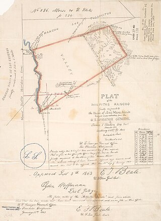
Rancho Milpitas was a 4,458-acre (18.04 km2) Mexican land grant in Santa Clara County, California. The name comes from the Nahuatl "milpan", a term meaning "in the field". Therefore, Milpitas could be translated as "little fields". The grant included what is now the city of Milpitas.
El Rancho Rinconada de los Gatos was a 6,631-acre (26.83 km2) Mexican land grant in present-day Santa Clara County, California made in 1840 by Governor Juan Alvarado to Jose Maria Hernandez and Sebastian Fabian Peralta. Located in the southern San Francisco Bay Area, the grant included present-day Los Gatos and Monte Sereno, along with about a third of Campbell. It also included small sections of present-day San Jose, Saratoga and unincorporated Santa Clara County. Los Gatos Creek flowed through the center of the rancho. The name means "corner of the cats" and is derived from the cougars that are still present in the nearby hills, as well as the "corner" formed by the narrowing gap between El Sereno and El Sombroso mountains.
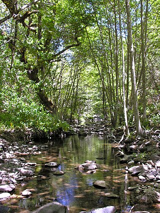
Smith Creek is a 14-mile-long (23 km) perennial stream which flows along the western flank of Mount Hamilton in Santa Clara County. The creek begins near Bollinger Ridge, about 7.7 km SxSW of Mount Hamilton.
Rancho San Ysidro was a 13,066-acre (52.88 km2) Spanish land grant in present-day Santa Clara County, California, given in 1809 by Governor José Joaquín de Arrillaga to Ygnacio Ortega. Today's city of Gilroy is on former Rancho Ysidro lands, as is nearby Old Gilroy.
Rancho Las Ánimas was a 26,519-acre (107.32 km2) Spanish land concession in present-day Santa Clara County given in 1803 by Viceroy Félix Berenguer de Marquina to José Mariano Castro. The rancho was regranted in 1835 to Castro's widow Josefa Romero de Castro by Mexican Governor José Figueroa. The present-day city of Gilroy is within the grant.
Rancho Salsipuedes was a 31,201-acre (126.27 km2) Mexican land grant in present day Santa Cruz County, California. Two leagues were granted in 1834 by Governor José Figueroa to Francisco de Haro. Eight leagues were granted in 1840 by Governor Juan Alvarado to Manuel Casarin. The name means "leave if you can" in Spanish. Salsipuedes encompasses the mountainous area west of Gilroy, straddling the Santa Clara County - Santa Cruz County line.
Rancho Santa Teresa was a 9,647-acre (39.04 km2) Mexican land grant in present-day Santa Clara County, California given in 1834 by Governor José Figueroa to José Joaquín Bernal. The grant extended west from Coyote Creek to the Santa Teresa Hills, and included present-day Santa Teresa.
Rancho Los Coches was a 2,219-acre (8.98 km2) Mexican land grant in present-day Santa Clara County, California given in 1844 by Governor Manuel Micheltorena to Roberto Balemino, an Indian. The name means Ranch of the Pigs. The grant was located on the west bank of Los Gatos Creek, south of San Jose, near the present-day Burbank. The historic Roberto Adobe and Suñol House is located within the former rancho.
Rancho San Francisco de las Llagas was a 22,283-acre (90.18 km2) Mexican land grant in present-day Santa Clara County, California given in 1834 by Governor José Figueroa to Carlos Antonio Castro. The grant extended along Llagas Creek from about one mile south of present-day Morgan Hill to about one mile north of Gilroy, and included present-day San Martin.
Rancho Ulistac was a 2,217-acre (8.97 km2) Mexican land grant in present-day Santa Clara County, California, given in 1845 by Governor Pío Pico to Marcello and Cristobal, Indians. The grant extended across lowlands reaching from the Alviso shoreline southward and encompassing the land between the Guadalupe River and Saratoga Creek, and the town of Agnew.
Rancho Potrero de Santa Clara was a 1,939-acre (7.85 km2) Mexican land grant in present day Santa Clara County, California given in 1844 by Governor Manuel Micheltorena to James Alexander Forbes. The name refers to the "pasture lands" of Santa Clara Mission. The grant was between the Santa Clara Mission and the Pueblo of San José, south of the present day San Jose International Airport.
Rancho Solis was a 8,875-acre (35.92 km2) Mexican land grant in present day Santa Clara County, California given in 1834 by Governor José Figueroa to Mariano Castro. The grant extended along Uvas Creek between present day Gilroy and Mount Madonna.
Rancho Cañada de Pala was a 15,714-acre (63.59 km2) Mexican land grant in present-day Santa Clara County, California given in 1839 by Governor Juan B. Alvarado to José de Jesús Bernal. The origin of the name Cañada de Pala is the subject of debate. The word "pala" translates as "shovel" in Spanish, but means "water", in many Native Californian dialects. The grant was in the foothills and mountains of the Diablo Range, east of San Jose and included most of what is now Grant Ranch Park and all of present-day Blue Oak Ranch Reserve.
Rancho Ex-Mission San José was a 30,000-acre (120 km2) Mexican land grant in present-day Alameda County, California given in 1846 by Governor Pio Pico to Andrés Pico and Juan B. Alvarado. The grant derives its name from the secularized Mission San José, and was called ex-Mission because of a division made of the lands held in the name of the Mission—the church retaining the grounds immediately around, and all of the lands outside of this are called ex-Mission lands. The grant extended to the lands of present-day Fremont including the former towns, now districts of Centerville, Irvington and Mission San Jose.
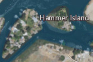
Hammer Island is a small island in the Sacramento–San Joaquin River Delta, in Contra Costa County, California, originally named Santos Island, it was changed to Hammer Island after Hans Hammer purchased the island from Mr. Santos in 1939. Its coordinates are 37°48′59″N121°33′25″W,; the United States Geological Survey measured its elevation as 0 ft (0 m) in 1981, and it appears on a 1978 USGS map.

Ogilvie Island is a patch of mud in San Francisco Bay. It is within the limits of the city of San Jose, in Santa Clara County, California, and named for county planner Arthur Ogilvie. Its coordinates are 37°27′55″N122°00′37″W, and the United States Geological Survey gave its elevation as 0 ft (0 m) in 2012. It appears on a 2012 USGS map of the area.
References
- ↑ Map: "Gilroy, California 7.5 Minute Quadrangle, 1985" U.S. Geological Survey.
- ↑ U.S. Geological Survey, National Geographic Names Database.
- ↑ Map: "Map of Southern Santa Clara County," (San Jose, California: Regal Map Company, 1967).
- ↑ Map: "Gilroy, California 7.5 Minute Quadrangle, 1985" U.S. Geological Survey.
- ↑ Holmes, Norman W., Prune Country Railroading: Steel Rails to San Jose, (Huntington Beach, California: Shade Tree Books, 1995), pp.135.
- ↑ California Region Timetable: 14, (Modesto, California: Altamont Press, 2003).
- ↑ Map: "Gilroy, California 7.5 Minute Quadrangle, 1985" U.S. Geological Survey.

