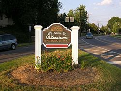
Old Southwest, Roanoke, Virginia

Last updated
Old Southwest
Old Southwest neighborhood of Roanoke, Virginia.jpg
Gateway signage along Elm Avenue
Coordinates: 37°15′51″N79°56′41″W / 37.26417°N 79.94472°W / 37.26417; -79.94472 Coordinates: 37°15′51″N79°56′41″W / 37.26417°N 79.94472°W / 37.26417; -79.94472
CountryUnited States
StateVirginia
City Roanoke
Elevation
1,004 ft (306 m)
Population
 (2000)
  Total3,628
Time zone UTC-5 (EST)
  Summer (DST) UTC-4 (EDT)
ZIP Codes
24016
Area code(s) 540
Website Old Southwest, Inc.

Old Southwest is a neighborhood of the independent city of Roanoke, Virginia, United States. Located geographically near the center of the city, Old Southwest was annexed from Roanoke County in 1890 and developed as one of Roanoke's more affluent residential areas. [1] Today the majority of the neighborhood falls within the Southwest Historic District listed on both the Virginia Landmarks Register and the National Register of Historic Places.

Contents

Location

Geographically, Old Southwest is defined by the city as the area bound by Jefferson Street (Virginia State Route 116) on the east, 10th Street to the west, the Norfolk and Western railroad tracks to the south and both Day and Marshall Avenue to the north. [1] It borders the neighborhoods of the Mountain View on the west, Wasena on the south and west, South Jefferson on the south and east, Downtown on the north and east and West End on the north. [2]

History

Annexed from Roanoke County in 1890, [1] the area now defined as Old Southwest was developed primarily between the years 1882 and 1930, to the southwest of Downtown Roanoke. [3] The neighborhood is predominantly residential with commercial generally concentrated along and east of Franklin Road. The neighborhood features a variety of architectural styles including but not limited to Queen Anne, Colonial Revival, Neoclassical, Bungalow, American Foursquare, Arts and Crafts and Shingle, [4] in addition to Roanoke's first public park, Highland Park, opened in 1901. [5]

Old Southwest would grow to become one of Roanoke's premier residential areas from its initial establishment through the years following World War Two when it would see the beginnings of a decline. By the 1970s, the neighborhood would begin to see a turnaround and the subsequent establishment of the Southwest Historic District in 1985. [6] The neighborhood boasts a number of carefully preserved historic buildings, including the Beth Israel Synagogue. More recent improvements to the neighborhood include the completion of the Highland Park dog park, Roanoke's first off-leash fenced dog park, which opened in May 2009, [7] and the opening of the Cotton Mill downtown housing project. [8]

The neighborhood's non-profit civic organization, Old Southwest, Inc, has received several national awards, including the Grand Prize 2010 National Neighborhood of the Year award and First Place in the Social Revitalization category from Neighborhoods USA. [9] It was previously recognized in 2008 with a second place award in the Social Revitalization category from Neighborhoods USA. [10]

Related Research Articles

This article is about the many neighborhoods and districts in the Greater Richmond, Virginia area. Note that this article is an attempt to be inclusive of the broader definitions of the areas which are often considered part of the Greater Richmond Region, based on their urban or suburban character and nature, rather than by strictly political boundaries.

Highland, Denver

Highland is a distinct city-center neighborhood in Denver, Colorado, bounded by West 38th Avenue to the north, a Union Pacific Railroad line on the east, the South Platte River to the southeast, Speer Boulevard on the south, and Federal Boulevard on the west. The Highlands is sometimes used to refer to two separate city-center neighborhoods in Denver; Highland and West Highland, although the two neighborhoods are distinct. Highland and West Highland are both in the area that is referred to as the Northside. Highland is located immediately northwest of downtown. Note that the Highland neighborhood association has a slightly different definition with the easternmost boundary stopping at I-25. And the West Highland neighborhood to the immediate west of Highland, with the borders of 38th and 29th Avenues on the north and south and Federal and Sheridan Boulevards on the east and west. To distinguish between its immediately adjacent neighbor, West Highland, Highland is sometimes referred to as East Highland, Lower Highland or LoHi. The two together are casually called "the Highlands," a term which often falsely encompasses other Northwest Denver neighborhoods such as Jefferson Park, Sunnyside and Berkeley. Realtors have particularly pushed the inclusion of the recently gentrified Berkeley, located directly north of West Highland, as part of the Highlands, sometimes going so far as to refer to Berkeley and parts of Sunnyside as the "Upper Highlands". To add further confusion, within the Highlands neighborhoods there are several historic designations of various degrees, including Potter Highlands, Scottish Highlands and Highlands Park.

Neighborhoods of Milwaukee Wikipedia list article

Neighborhoods of Milwaukee, Wisconsin.

Planning and development in Detroit since the late 20th century has attempted to enhance the economy and quality of life of Detroit, Michigan, United States. In 1970, the private group Detroit Renaissance began to facilitate development in the city. Its successor, Business Leaders for Michigan, has continued to facilitate development into the 21st century. Projects have included new commercial facilities, revitalization of neighborhoods, hospitality infrastructure, and improvements to recreational and public facilities, such as the QLine light rail project.

Wasena, Roanoke, Virginia Roanoke Neighborhood in Virginia, United States

Wasena is a Roanoke, Virginia neighborhood located in south, central Roanoke bisected by U.S. Route 221, immediately to the south of the Roanoke River. It borders the neighborhoods of Raleigh Court on the west, Old Southwest on the north and east and Mountain View via the Wasena Bridge across the Roanoke River on the north, and Franklin-Colonial on the south. As of the 2000 U.S. Census, Wasena has a population of 1,633 residents.

South Jefferson, Roanoke, Virginia Roanoke Neighborhood in Virginia, United States

South Jefferson is a Roanoke, Virginia neighborhood located in southeast Roanoke, surrounded roughly by the Roanoke River to the south and east and the Roy L. Webber Expressway to the west, centered on South Jefferson Street. It borders the neighborhoods of Old Southwest on the west, Belmont and Downtown on the north, and Riverland/Walnut Hills via the Walnut Street Bridge on the east.

Gainsboro, Roanoke, Virginia Roanoke Neighborhood in Virginia, United States

Gainsboro is a Roanoke, Virginia neighborhood located in central Roanoke immediately north of Downtown, across the Norfolk Southern Railway right of way, between Interstate 581 and Orange Avenue. It borders the neighborhoods of Harrison and Gilmer on the west, Washington Park on the north, Williamson Road on the east and Downtown Roanoke on the south. As of the 2000 U.S. Census, Gainsboro has a population of 967 residents.

Raleigh Court, Roanoke, Virginia Roanoke Neighborhood in Virginia, United States

Raleigh Court is a Roanoke, Virginia neighborhood located in southwest Roanoke along U.S. 11. It borders the neighborhoods of Greater Deyerle on the west, Wasena on the east, Cherry Hill, Mountain View and Norwich on the north and Franklin-Colonial and Grandin Court on the south. Today the neighborhood is accessed from the downtown areas via the Memorial Bridge across the Roanoke River. As of the 2000 U.S. Census, Raleigh Court has a population of 11,200 residents.

Hurt Park is a Roanoke, Virginia neighborhood located in central Roanoke between the Norfolk Southern railyard and the Roanoke River. It borders the neighborhoods of Cherry Hill on the west, West End on the east, Gilmer, Loudon-Melrose and Shenandoah West on the north across the Norfolk Southern railyard and Norwich across the Roanoke River and Mountain View on the south.

West End is a Roanoke, Virginia neighborhood located in central Roanoke south of the Norfolk Southern railyard. It borders the neighborhoods of Hurt Park and Mountain View on the west, Downtown on the east, Gilmer on the north across the Norfolk Southern railyard and Old Southwest on the south.

Mountain View, Roanoke, Virginia Roanoke Neighborhood in Virginia, United States

Mountain View is a Roanoke, Virginia neighborhood located in central Roanoke north of the Roanoke River. It borders the neighborhoods of Norwich on the west, West End on the east, Hurt Park on the north and Raleigh Court and Wasena on the south.

Downtown Roanoke Roanoke Neighborhood in Virginia, United States

Downtown is the central business district of Roanoke, Virginia, United States. Located geographically at the center of the city, Downtown began its development with the completion of the Shenandoah Valley Railroad in 1882. Today the Downtown core is noted as the center of business for the Roanoke Valley and Southwest Virginia, the Roanoke City Market, the Roanoke Downtown Historic District and many other attractions and amenities.

Southern Hills is a neighborhood of the independent city of Roanoke, Virginia, United States. Located geographically as the city's southernmost neighborhood, Southern Hills was annexed from Roanoke County in 1976 and has seen significant residential and commercial development since the 1990s. It borders the neighborhoods of the Franklin-Colonial and South Roanoke on the north, Garden City on the east and Roanoke County on the south and west. Its western boundary runs concurrent with U.S. 220.

Greater Deyerle is a Roanoke, Virginia neighborhood located in extreme southwest Roanoke. It borders the neighborhoods of Raleigh Court on the east, Cherry Hill on the north, the city of Salem on the west and Roanoke County on the south. Greater Deyerle is geographically the most western area of the city of Roanoke.

Many Neighborhoods of Toledo, Ohio are of historic interest.

Four Corners (Newark) United States historic place

The Four Corners Historic District is the intersection of Broad and Market streets in Newark, New Jersey. It is the site of the city's earliest settlement and the heart of Downtown Newark that at one time was considered the busiest intersection in the United States. The area that radiates 22 square blocks from the crossroads is a state and federal historic district.

Gentrification of Atlanta

Gentrification of Atlanta's inner-city neighborhoods began in the 1970s, and it has continued, at varying levels of intensity, into the present. Many factors have contributed to the city's gentrification. A major increase in gentrification that occurred in the last years of the twentieth century has been attributed to the 1996 Summer Olympics. However, during the 2000s, Atlanta underwent a profound transformation demographically, physically, and culturally. Suburbanization, rising prices, a booming economy, and new migrants decreased the city’s black percentage from a high of 67% in 1990 to 54% in 2010. From 2000 to 2010, Atlanta gained 22,763 white residents, 5,142 Asian residents, and 3,095 Hispanic residents, while the city’s black population decreased by 31,678. Much of the city’s demographic change during the decade was driven by young, college-educated professionals: from 2000 to 2009, the three-mile radius surrounding Downtown Atlanta gained 9,722 residents aged 25 to 34 holding at least a four-year degree, an increase of 61%. Between the mid-1990s and 2010, stimulated by funding from the HOPE VI program, Atlanta demolished nearly all of its public housing, a total of 17,000 units and about 10% of all housing units in the city. In 2005, the $2.8 billion BeltLine project was adopted, with the stated goals of converting a disused 22-mile freight railroad loop that surrounds the central city into an art-filled multi-use trail and increasing the city’s park space by 40%. Lastly, Atlanta’s cultural offerings expanded during the 2000s: the High Museum of Art doubled in size; the Alliance Theatre won a Tony Award; and numerous art galleries were established on the once-industrial Westside.

Eastside, Atlanta City district of Atlanta, Georgia

Eastside refers to the city district comprising the easternmost portion of Atlanta, Georgia, United States. The Eastside generally encompasses the area bounded on the west by Midtown Atlanta and Downtown Atlanta and on the east by the city limits. The central corridor of the district is the BeltLine Eastside Trail, which connects northern Eastside neighborhoods with those to the south. The Eastside is known for its nightlife establishments, craftsman architecture, local eateries, and quirky public art.

References

  1. 1 2 3 "Old Southwest Neighborhood Plan". City of Roanoke: Planning Division. 20 July 2009. p. 1. Retrieved 23 September 2016.
  2. "Explore Roanoke Neighborhood Map: Old Southwest". City of Roanoke Department of Neighborhoods. Retrieved 2008-08-04.[ permanent dead link ]
  3. "National Register of Historic Places nomination, Southwest Historic District" (PDF). Archived from the original (PDF) on 2012-09-27. Retrieved 2008-09-03.
  4. "Old Southwest, Inc - Roanoke, Virginia - Neighborhood History". oldsouthwest.org. Archived from the original on 11 July 2016. Retrieved 12 July 2016.
  5. "Old Southwest Neighborhood Plan". City of Roanoke: Planning Division. 20 July 2009. p. 7. Retrieved 23 September 2016.
  6. "History". Old Southwest, Inc. Archived from the original on 2008-09-27. Retrieved 2008-09-03.
  7. "Old Southwest Neighborhood Plan". City of Roanoke: Planning Division. 20 July 2009. p. 51. Retrieved 23 September 2016.
  8. "The Cotton Mill in Downtown Roanoke". thecottonmilllofts.com. Retrieved 23 September 2016.
  9. "Archived copy". Archived from the original on 2011-07-27. Retrieved 2011-01-25.{{cite web}}: CS1 maint: archived copy as title (link)
  10. "Archived copy". Archived from the original on 2018-08-13. Retrieved 2018-08-13.{{cite web}}: CS1 maint: archived copy as title (link)