Laura is a rural town in the Mid North region of South Australia, 12 km north of Gladstone on the Horrocks Highway and 40 km east of Port Pirie. The first European to explore the district was Thomas Burr in September 1842. His promising reports soon led to occupation of the district by pastoralists, one of whom was Herbert Bristow Hughes. When the present town was surveyed he named it for his wife, Laura née White.
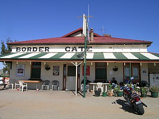
Cockburn is a town and locality in the east of the Australian state of South Australia immediately adjacent to the border with New South Wales near Broken Hill. It was established because the New South Wales government refused to allow locomotives of the South Australian Railways to operate in its jurisdiction, requiring locomotives to be changed at the town for 84 years until 1970, when the route was converted from 1067 mm to 1435 mm standard gauge.

Tantanoola is a town in regional South Australia. The name is derived from the aboriginal word tentunola, which means boxwood / brushwood hill or camp. Tantanoola was originally named 'Lucieton' by Governor Jervois after his daughter Lucy Caroline, on 10 July 1879. It was changed by Governor Robinson to 'Tantanoola' on 4 October 1888. At the 2006 census, Tantanoola had a population of 255.
Marla is a town and locality in the Australian state of South Australia located in the state's north-west about 970 kilometres (600 mi) north-west of the state capital of Adelaide and about 402 kilometres (250 mi) south of the town of Alice Springs in the Northern Territory.

Paratoo is a locality in the Australian state of South Australia located about 254 kilometres (158 mi) north-east of the state capital of Adelaide and about 52 kilometres (32 mi) north-east of the municipal seat in Peterborough.
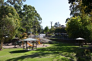
Bridgewater is a town in South Australia, located in the Adelaide Hills to the south-east of the Adelaide city centre.
Wolseley is a small South Australian town near the Victorian border. It is five kilometres south of the Dukes Highway and 13 kilometres east of Bordertown. It was first proclaimed a town in 1884.

Buccleuch is a place in South Australia situated along the Pinnaroo railway line and Mallee Highway (B12), approximately 140 km east of Adelaide. It is part of the Coorong District Council. There is an active Lutheran Church in Buccleuch.

Para Wirra Conservation Park is a 1,417-hectare (3,500-acre) protected area located in the foothills of the Mount Lofty Ranges in the northern end of the Adelaide metropolitan area in South Australia. The conservation park is part of a larger, 2,573-hectare (6,360-acre) block of contiguous native vegetation, the remainder of which is owned by PIRSA Forestry, SA Water and private landholders.
Burrungule is a locality in South Australia.
Cockaleechie is a locality on Eyre Peninsula in South Australia.

Rendelsham is a town in the south-east of South Australia, 392 kilometres (244 mi) south east of the state capital, Adelaide. It is on the Southern Ports Highway between Beachport and Millicent.
Wirrabara is a town and a locality in South Australia, about 235 kilometres (146 mi) north of Adelaide. It is located in the Southern Flinders Ranges in the Mid North of South Australia, along the Rocky River. The Horrocks Highway passes through the town. At the 2016 census, the locality had a population of 403 of which 230 lived in its town centre.
Ucolta is a locality in the Mid North region of South Australia. It is named for a railway station on the Broken Hill-Port Pirie railway line. Trains no longer stop at Ucolta. It is also where the Barrier Highway first meets the railway line, and the Wilmington–Ucolta Road which connects across the northern side of the Mid North, providing the shortest road route from Western Australia and Eyre Peninsula via Port Augusta to Broken Hill and New South Wales.
Hammond is a town and locality in the Australian state of South Australia located in the southern Flinders Ranges.
Dawson is a rural locality in the Mid North region of South Australia, situated in the District Council of Peterborough. It covers the entirety of the cadastral Hundred of Coglin, with the exception of the small town of Oodla Wirra.

Mount Mary is a small town on the Thiele Highway between Eudunda and Morgan in South Australia. It was also served by the Morgan railway line from 1878 until 1969 and is named for the Mount Mary railway station on that line.
Stewart Range is a locality in the Australian state of South Australia located about 289 kilometres (180 mi) south-east of the state capital of Adelaide and about 12 kilometres (7.5 mi) west of the municipal seat of Naracoorte.
Mercunda is a town and a locality in the Australian state of South Australia located in the state's south-east about 134 kilometres (83 mi) east of the state capital of Adelaide, and about 52 kilometres (32 mi) north-east and about 53 kilometres (33 mi) south-west respectively of the municipal seats of Karoonda and Loxton.
Kringin is a town and a locality in the Australian state of South Australia located in the state’s east about 199 kilometres (124 mi) east of the state capital of Adelaide and about 61 kilometres (38 mi) south of the municipal seat of Loxton.

