Nackara, South Australia

Last updated

Nackara
South Australia
Hundred of Nackara1963 (23155107884).jpg
Hundred of Nackara, 1963
Australia South Australia location map.svg
Red pog.svg
Nackara
Coordinates 32°48′07″S139°14′38″E / 32.802042°S 139.243781°E / -32.802042; 139.243781 Coordinates: 32°48′07″S139°14′38″E / 32.802042°S 139.243781°E / -32.802042; 139.243781 [1]
Population3 (2016 census) [2]
Postcode(s) 5440
Time zone ACST (UTC+9:30)
 • Summer (DST) ACDT (UTC+10:30)
LGA(s) District Council of Peterborough [1]
Region Yorke and Mid North [1]
County Herbert [1]
State electorate(s) Stuart [3]
Federal Division(s) Grey [4]
Mean max temp [5] Mean min temp [5] Annual rainfall [5]
24.6 °C
76 °F
9.5 °C
49 °F
207.9 mm
8.2 in
Localities around Nackara:
Cavenagh Paratoo Grampus
Dawson Nackara Grampus
Parnaroo Parnaroo
Hardy
Warnes
FootnotesAdjoining localities [1]

Nackara (formerly Tregu) is a locality and former farming town in South Australia, 47 kilometres east of Peterborough on the Barrier Highway. It was originally proclaimed as the Government Town of Tregu on July 2, 1891 but the name was changed to Nackara in 1940 to match the name of the railway station. [6]

Contents

History

The Nackara 'township' was created as a railway siding on the Peterborough (South Australia) to Broken Hill (New South Wales) train line which was completed in approximately 1888, mainly to transport the ore from the Broken Hill mines to the South Australian port(s).

The town was planned to have several streets with suburban style yards, however this never eventuated. The Nackara township never consisted of more than a few railway cottages, a town store/post office (part of a house), a community hall ('The Nackara Institute'), a Catholic church, a Presbyterian Church, a school, the railway platform, cattle yards and cemetery. The planned roads didn't ever eventuate, with only dirt tracks through the very dry paddocks.

The community consisted of families from the surrounding grazing land, and the railway workers. While the township never grew as planned, the community did have many social events such as picnics, town dances and concerts, annual horse races, and car races. The town also competed against the other local towns in at least rugby and cricket.

The local population were mainly immigrants (many Catholics from Ireland and several Polish families), and mainly worked as sheep and cattle graziers, railway workers, wood carters, shearers and labourers. There was a vibrant local Catholic community who had annual Catholic Picnics to raise money to erect a Catholic church. The church (St. Patrick's) was a small church built of stone on the top of the hill overlooking the Nackara township.

Current

The area is too dry to support much livestock, so Nackara never grew beyond around 20 families and the township didn't develop. After the railway was realigned several kilometres to the south around the 1960s, the town practically died. There are only several graziers left in the area now.

Nackara School and the disused Nackara Institute (community hall) are all that remain standing within the Nackara township. The school is now a private residence. The (corrugated iron) Presbyterian church has gone, the Catholic Church was demolished (around the 1960s), the main store (home and post office) is now stone rubble with a chimney.

Related Research Articles

Naracoorte, South Australia Town in South Australia

Naracoorte is a town in the Limestone Coast region of South Australia, approximately 336 kilometres south-east of Adelaide and 100 kilometres north of Mount Gambier on the Riddoch Highway (A66).

Karoonda, South Australia Town in South Australia

Karoonda is in the middle of the Murray Mallee region of South Australia. Karoonda takes its name from the Aboriginal word for "winter camp". The current boundaries include the former town of Lowaldie, which was the next stop on the railway line away from Adelaide.

Hawker, South Australia Town in South Australia

Hawker is a town and a locality in the Flinders Ranges area of South Australia, 365 kilometres (227 mi) north of Adelaide. It is in the Flinders Ranges Council, the state Electoral district of Stuart and the federal Division of Grey. At the 2016 census, the locality had a population of 341 of which 237 lived in its town centre.

Penola, South Australia Town in South Australia

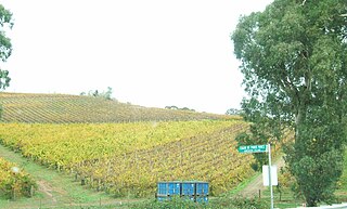
Penola is a town in the Australian state of South Australia located about 388 kilometres (241 mi) southeast of the state capital of Adelaide in the wine growing area known as the Coonawarra. At the 2016 census, town of Penola had a population of 1,312.

Lameroo, South Australia Town in South Australia

Lameroo is a town in the Murray Mallee region of South Australia. It is on the Mallee Highway and Pinnaroo railway line about 40 km west of the Victorian border, or 210 km east of Adelaide. It is primarily a service town for the surrounding rural areas, growing grain and sheep. Lameroo now includes the former settlements of Kulkami, Mulpata, Wirha and Gurrai, which were on the Peebinga railway line, and Wilkawatt, which was between Parrakie and Lameroo on the Pinnaroo railway.

Paratoo, South Australia Suburb of District Council of Peterborough, South Australia

Paratoo is a locality in the Australian state of South Australia located about 254 kilometres (158 mi) north-east of the state capital of Adelaide and about 52 kilometres (32 mi) north-east of the municipal seat in Peterborough.

Clare, South Australia Town in South Australia

The town of Clare is located in South Australia in the Mid North region, 136 km north of Adelaide. It gives its name to the Clare Valley wine and tourist region.

Kalangadoo, South Australia Town in South Australia

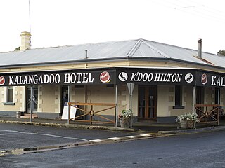
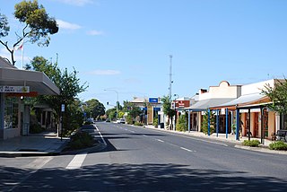
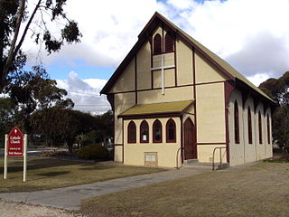
Kalangadoo is a locality in the Australian state of South Australia located about 348 kilometres (216 mi) south-east of the state capital of Adelaide and about 31 kilometres (19 mi) north of the regional centre of Mount Gambier.

Willunga, South Australia Suburb of Adelaide, South Australia

Willunga is a town south of Adelaide, South Australia in the City of Onkaparinga local government area 47 km from the Adelaide city centre. Sometimes considered a suburb of the Adelaide metropolitan area, it is located within the famous McLaren Vale wine growing region. At the 2016 census, Willunga had a population of 2,308.

Cowell, South Australia Town in South Australia

Cowell is a coastal town on Franklin Harbor on the eastern side of the Eyre Peninsula, in South Australia on the Lincoln Highway 111 km south of the major town of Whyalla. It is 493 km by road from Adelaide.

Chain of Ponds, South Australia Suburb of Adelaide Hills Council, South Australia

Chain of Ponds is a locality and former town near Adelaide, South Australia. It is located in the Adelaide Hills Council local government area.

Kingoonya Town in South Australia

Kingoonya, historically spelt Kingoonyah, is a small almost totally abandoned farming settlement in the central outback of the Australian state of South Australia. It was established in the early 1900s as a railway support town for the 200 or so sheep farming families on the train-line extending west across the Nullarbor Plain to Western Australia. It played a significant role in the construction of the Trans-Australian Railway.

Yunta, South Australia Town in South Australia

Yunta is a town and locality in the Australian state of South Australia located in the state's east about 275 kilometres (171 mi) north-east of the state capital of Adelaide. It is a service centre supporting both the local area and travellers passing through on the Barrier Highway. It lies south west of Broken Hill and north east of Peterborough.

Eurelia Town in South Australia

Eurelia is a town and locality in the Australian state of South Australia located on the east side of the Flinders Ranges about 264 kilometres (164 mi) north of the state capital of Adelaide and about 20 kilometres (12 mi) from the municipal seat of Orroroo.

Mannahill, South Australia Town in South Australia

Mannahill is a town and locality in the Australian state of South Australia. Mannahill is in the Northeast Pastoral district and is one of the easternmost settlements in South Australia.

Whyte Yarcowie, South Australia Town in South Australia

Whyte Yarcowie is a town and locality in the Australian state of South Australia. It is on the Barrier Highway between Hallett and Terowie.

Ucolta, South Australia Town in South Australia

Ucolta is a locality in the Mid North region of South Australia. It is named for a railway station on the Broken Hill-Port Pirie railway line. Trains no longer stop at Ucolta. It is also where the Barrier Highway first meets the railway line, and the Wilmington–Ucolta Road which connects across the northern side of the Mid North, providing the shortest road route from Western Australia and Eyre Peninsula via Port Augusta to Broken Hill and New South Wales.

Hammond, South Australia Town in South Australia

Hammond is a town and locality in the Australian state of South Australia located in the southern Flinders Ranges.

Dawson, South Australia Town in South Australia

Dawson is a rural locality in the Mid North region of South Australia, situated in the District Council of Peterborough. It covers the entirety of the cadastral Hundred of Coglin, with the exception of the small town of Oodla Wirra.

Moockra, South Australia Suburb of Flinders Ranges, South Australia

Moockra is a locality in the Australian state of South Australia located on the eastern side of the Flinders Ranges about 274 kilometres (170 mi) north of the state capital of Adelaide and about 47 kilometres (29 mi) north-east and 36 kilometres (22 mi) south-east respectively of the municipal seats of Melrose and Quorn.

References

  1. 1 2 3 4 5 "Search results for 'Nackara, LOCB' with the following datasets selected - 'Suburbs and localities', 'Government Towns', 'Counties', 'SA Government Regions', 'Local Government Areas' and 'Gazetteeer'". Location SA Map Viewer. South Australian Government. Retrieved 8 February 2018.
  2. Australian Bureau of Statistics (27 June 2017). "Nackara(State Suburb)". 2016 Census QuickStats. Retrieved 8 February 2018. OOjs UI icon edit-ltr-progressive.svg
  3. "District of Stuart Background Profile (2014-2018 boundaries)". Electoral Commission SA. Retrieved 27 December 2017.
  4. "Federal electoral division of Grey" (PDF). Australian Electoral Commission. Retrieved 27 December 2017.
  5. 1 2 3 "Monthly climate statistics: Summary statistics YUNTA AIRSTRIP (nearest station)". Commonwealth of Australia , Bureau of Meteorology. Retrieved 29 January 2018.
  6. "NEW TOWN NAMES APPROVED". The Advertiser (Adelaide) . South Australia. 26 July 1940. p. 10. Retrieved 5 September 2016 via National Library of Australia.