
Ancroft is a village and civil parish in Northumberland, England. Prior to 1844, Ancroft lay within the Islandshire exclave of County Durham. It is south of Berwick-upon-Tweed, and has a population of 885, rising slightly to 895 at the 2011 census.
Coldstream is a town and civil parish in the Scottish Borders area of Scotland. A former burgh, Coldstream is the home of the Coldstream Guards, a regiment in the British Army.
Berwick-upon-Tweed was a local government district and borough in Northumberland in the north-east of England, on the border with Scotland. The district had a resident population of 25,949 according to the 2001 census, which also notes that it is the most ethnically homogeneous in the country, with 99.6% of the population recording themselves in the 2001 census as White. It was also the smallest district in England with borough status, and the third-least densely populated local government district.

Norham is a village and civil parish in Northumberland, England, on the south side of the River Tweed where it is the border with Scotland.

Akeld is a village and civil parish in Northumberland, England. It is situated to the west of Wooler, and in 2001 had a population of 82, increasing at the 2011 Census to 221, although this was partly due to the parish merging with that of Kirknewton. Its name is Anglo-Saxon Old English ac-helde, 'oak slope'.

Bowsden is a village and civil parish in Northumberland, England. It is about 6 miles (10 km) to the south of Berwick-upon-Tweed, inland from the North Sea coast at Lindisfarne, and has a population of 157, rising to 178 at the 2011 Census.

Capheaton is a village in Northumberland, in England, about 25 miles (40 km) to the northwest of Newcastle upon Tyne. The population at the 2001 census was 160, increasing to 175 at the 2011 Census. It was built as a planned model village in the late eighteenth century. The name Capheaton is really Caput Heaton, i.e., Heaton Magna, nearby Kirkheaton being the original Heaton Parva.
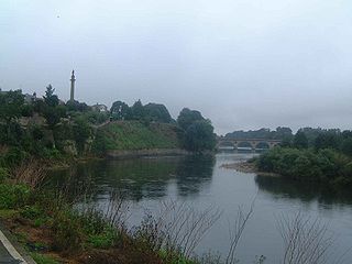
Cornhill-on-Tweed is a small village and civil parish in Northumberland, England about 1 mile (1.6 km) to the east of Coldstream, Scotland. The hamlets of West Learmouth and East Learmouth are located to the south and west of the village respectively.
Bewick is a civil parish in the county of Northumberland, England. In 2001 it had a population of 69, increasing to 138 at the 2011 Census. The parish consists of the hamlets of Old Bewick and New Bewick, both about 10 miles (16 km) north-west of Alnwick. The parish was formed on 1 April 1955 from the parishes of Old Bewick and New Bewick.
Ancroft Northmoor is a village in Northumberland, England. The population of the Civil Parish taken at the 2011 census was 895.
North Sunderland is a fishing village on the coast of Northumberland, England, and adjacent to Seahouses. The population of the civil parish was 1,803 at the 2001 census, increasing to 1,959 at the 2011 Census.

Lowick is a village in Northumberland, north east England. Lowick lies on the B6353 road, about 10 miles (16 km) south of Berwick-upon-Tweed. The Anglican St John the Baptist's Parish Church dates from 1794, but a chapel was built in the 12th century by monks of Lindisfarne. The Grade II* listed Barmoor Castle, a castellated Tudor style country house is about a mile to the west of the village.

Longhoughton is a small rural village in Northumberland, England. It lies near the coast, about 4.5 miles (7.2 km) northeast of Alnwick, in the similarly named parish of Longhoughton.

Great Whittington is a village in Northumberland, England, 7 miles NE of Hexham with a population of 401, as of the 2011 British Census and an area of 1494 acres, most of which is used as farmland, with only 12 acres urbanized.
Middleton is a civil parish in Northumberland, England. The parish is situated on the North Sea coast, south of the island of Lindisfarne, and contains the villages of Middleton, Ross, Detchant and Elwick; all are shrunken medieval villages. Both the A1 London to Edinburgh road and East Coast Main Line pass through the parish. In the 2001 census the parish had a population of 136, falling to 115 at the 2011 Census.

Carham or Carham on Tweed is a village in Northumberland, England. The village lies on the south side of the River Tweed about 3 miles (5 km) west of Coldstream. According to the United Kingdom Census 2011, it is the place in England with greatest proportion of Scottish-born people, at approximately 33%.

East Ord is a village in Northumberland, England about 2 miles (3 km) south west of Berwick Upon Tweed. It lies on the south bank of the River Tweed adjacent to the A1 Road.

Kilham is a hamlet and civil parish in the English county of Northumberland, located 8.0 miles (12.9 km) west of Wooler, 12.0 miles (19.3 km) east of Kelso, 17.0 miles (27.4 km) south west of Berwick upon Tweed and 38.9 miles (62.6 km) north west of Morpeth. It lies on the northern edge of the Northumberland National Park in Glendale. The hamlet, which consists of a small group of agricultural dwellings, is overlooked by Kilham Hill and the northern limits of the Cheviot Hills. The parish had a population of 131 in 2001, and includes the hamlets of Howtel and Pawston, along with the former upland township of Coldsmouth and Thompson's Walls. falling to less than 100 at the 2011 Census. Details are now included in the parish of Branxton
