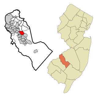
Echelon is an unincorporated community and census-designated place (CDP) located within Voorhees Township in Camden County, New Jersey, United States. As of the 2010 United States Census, the CDP's population was 10,743.

Voorhees Township is a township in Camden County, New Jersey, United States. As of the 2010 United States Census, the township's population was 29,131, reflecting an increase of 1,005 (+3.6%) from the 28,126 counted in the 2000 Census, which had in turn increased by 3,567 (+14.5%) from the 24,559 counted in the 1990 Census. Voorhees is a New Jersey suburb in the Greater Philadelphia Metropolitan Area.

Bethlehem Township is a township in Hunterdon County, New Jersey, United States. It is part of the New York metropolitan area. As of the 2010 United States Census, the township's population was 3,979, reflecting an increase of 159 (+4.2%) from the 3,820 counted in the 2000 Census, which had in turn increased by 716 (+23.1%) from the 3,104 counted in the 1990 Census.
Califon is a borough in Hunterdon County, New Jersey, United States. As of the 2010 United States Census, the borough's population was 1,076, reflecting an increase of 21 (+2.0%) from the 1,055 counted in the 2000 Census, which had in turn declined by 18 (-1.7%) from the 1,073 counted in the 1990 Census.

Clinton is a town in Hunterdon County, New Jersey, United States, located on the South Branch of the Raritan River in the Raritan Valley region. As of the 2010 United States Census, the town's population was 2,719, reflecting an increase of 87 (+3.3%) from the 2,632 counted in the 2000 Census, which had in turn increased by 578 (+28.1%) from the 2,054 counted in the 1990 Census. Despite its relatively small population, Clinton is the predominant control city for Interstate 78 traveling westbound from Newark.

Clinton Township is a township in Hunterdon County, New Jersey, United States. The township is in the Raritan Valley region and is located in the New York metropolitan area. As of the 2010 United States Census, the township's population was 13,478, reflecting an increase of 521 (+4.0%) from the 12,957 counted in the 2000 Census, which had in turn increased by 2,141 (+19.8%) from the 10,816 counted in the 1990 Census.

Franklin Township is a township in central Hunterdon County, New Jersey, United States. As of the 2010 United States Census, the township's population was 3,195, reflecting an increase of 205 (+6.9%) from the 2,990 counted in the 2000 Census, which had in turn increased by 139 (+4.9%) from the 2,851 counted in the 1990 Census. Most of the township lies on the Hunterdon Plateau with only the eastern section along the South Branch Raritan River being on the lower part of the Newark Basin.

High Bridge is a borough in Hunterdon County, New Jersey, United States. As of the 2010 United States Census, the borough's population was 3,648, reflecting a decline of 128 (-3.4%) from the 3,776 counted in the 2000 Census, which had in turn declined by 110 (-2.8%) from the 3,886 counted in the 1990 Census.
Lebanon Township is a township located at the northernmost point of Hunterdon County, New Jersey, United States. As of the 2010 United States Census, the township's population was 6,588, reflecting an increase of 772 (+13.3%) from the 5,816 counted in the 2000 Census, which had in turn increased by 137 (+2.4%) from the 5,679 counted in the 1990 Census.

Tewksbury Township is a township located in Hunterdon County, New Jersey and is located within the New York Metropolitan Area. As of the 2010 United States Census, the township's population was 5,993, reflecting an increase of 452 (+8.2%) from the 5,541 counted in the 2000 Census, which had in turn increased by 738 (+15.4%) from the 4,803 counted in the 1990 Census. It is located within the Raritan Valley region.

Union Township is a township in Hunterdon County, New Jersey, United States. As of the 2010 United States Census, the township's population was 5,908, reflecting a decline of 252 (-4.1%) from the 6,160 counted in the 2000 Census, which had in turn increased by 1,082 (+21.3%) from the 5,078 counted in the 1990 Census. The southwest half of the township lies on what is known as the Hunterdon Plateau, the northwest corner consists of the Musconetcong Ridge and the northeast section is part of the lower-lying Newark Basin around Spruce Run Reservoir.

Voorhees High School is a four-year public high school located in Lebanon Township, New Jersey, named for Foster McGowan Voorhees, the 30th Governor of New Jersey. It is one of two high schools in the North Hunterdon-Voorhees Regional High School District, serving students in ninth through twelfth grades from six municipalities in northern Hunterdon County, New Jersey, United States. The school has been accredited by the Middle States Association of Colleges and Schools Commission on Elementary and Secondary Schools since 1977.
The Voorhees Township Public Schools is a comprehensive community public school district serving students in pre-kindergarten through eighth grade from Voorhees Township, in Camden County, New Jersey, United States.
Voorhees Town Center is a regional shopping mall and a residential area located in Voorhees Township, New Jersey, United States. It was built in 1970 and named after Echelon Airfield which was located where the mall stands today. The Echelon Mall was renamed Voorhees Town Center in 2007. Boscov's currently serves as the only anchor of the mall.
The Bethlehem Township School District is a community public school district that serves students in kindergarten through eighth grade from Bethlehem Township, in Hunterdon County, New Jersey, United States.
The Tewksbury Township Schools is a community public school district which operates two schools serving students in kindergarten through eighth grade from Tewksbury Township, in Hunterdon County, New Jersey, United States.
The Union Township School District is a community public school district that serves students in kindergarten through eighth grade from Union Township, in Hunterdon County, New Jersey, United States. A new elementary school, named "Union Township Elementary School", opened for the 2006-2007 school year. The older building was renamed Union Township Middle School.
Cherry Hill is a township within Camden County, in the U.S. state of New Jersey. As of the 2020 United States Census, the township had a population of 74,553, reflecting an increase of 3,508 (+1.04%) from the 71,045 counted in the 2010 Census, which had in turn increased by 1,080 (+1.01%) from the 69,965 counted in the 2000 Census. As of 2020, the township was the state's 12th most populous municipality and the largest in Camden County, after having been the state's 13th most populous municipality in the 2000 Census. Cherry Hill is a suburb of Philadelphia and with the decline of downtown Camden has become an edge city and one of the region's main commercial centers. Cherry Hill is situated on the Delaware Valley coastal plain, approximately eight miles southeast of Center City, Philadelphia.

The Middlebush Village Historic District is a historic district located in the Village of Middlebush, an unincorporated community within Franklin Township, Somerset County, New Jersey. The district was added to the National Register of Historic Places on April 24, 2007. It includes 37 contributing buildings and three contributing sites.

Kresson is an unincorporated community located within Voorhees Township, in Camden County, New Jersey, United States. The community was named for George Kress, who ran a local general store. Kresson Golf Course is a public golf course located in the area, near Route 73 and Kresson Lake.


