
Nagaland is a landlocked state in the north-eastern region of India. It is bordered by the Indian states of Arunachal Pradesh to the north, Assam to the west, Manipur to the south, and the Sagaing Region of Myanmar (Burma) to the east. Its capital city is Kohima and its largest city is the twin Chümoukedima–Dimapur. The state has an area of 16,579 square kilometres (6,401 sq mi) with a population of 1,980,602 as per the 2011 Census of India, making it one of the smallest states of India.

Kohima is the capital of the Indian state of Nagaland. With a resident population of almost 100,000, it is the second largest city in the state. Kohima constitutes both a district and a municipality. The municipality covers 20 km2 (7.7 sq mi). The city lies on the foothills of Japfü section of the Barail Range located south of the District and has an average elevation of 1,261 m (4,137 ft).
The Angamis are a major Naga ethnic group predominantly inhabiting the Kohima District, Chümoukedima District and Dimapur District in the Northeast Indian state of Nagaland. The Angamis are divided into four regions namely Chakhro Angami, Northern Angami, Southern Angami and Western Angami. The now separated Chakhesangs were previously known as the Eastern Angamis.

Dimapur is the largest city and municipality in the Indian state of Nagaland. As of 2011, the municipality had a population of 122,834. The city is the main gateway and commercial centre of Nagaland. Located near the border with Assam along the banks of the Dhansiri River. Its main railway station is the second busiest station in Northeast India.

Dimapur District (Pron:/ˌdɪməˈpʊə/) is a district of Nagaland state in India. With an area of about 70 km2 (27 sq mi), it is the smallest district in the state of Nagaland.

Kohima District is a district of the Indian state of Nagaland. It is the home of the Angami Nagas. As of 2011, it is the most populous district of Nagaland, with a population of 267,988, 45% of which is urban. The district is home to 13.55% of Nagaland's entire population. The administrative headquarters of the district is located at Kohima, the capital city of Nagaland. Kohima District is also the seventh-largest district in Nagaland with an area of 1,207 square kilometres (466 sq mi).
Phek District (pron:/ˈfɛk/) is a district in the Indian state of Nagaland. At 2,026 square kilometres (782 sq mi), the district is the seventh-most populous district in Nagaland and 596th most populous district in India with 163,418 inhabitants. The district is home to 8.26% population of Nagaland. The district headquarter is located at Phek, 120 kilometres from Kohima, the capital of Nagaland and the largest urban centre is Pfütsero.

Chümoukedima, formerly spelled Chumukedima, is a municipality in the Chümoukedima District of the Indian state of Nagaland. It is situated on the left bank of the Chathe and with its surrounding area that includes several other towns and villages, the Chümoukedima Metropolitan Area is the largest urban agglomeration in Nagaland in terms of area and third largest in terms of population, after Dimapur and Kohima.

Wokha is a town and municipality in the Indian state of Nagaland. It is the headquarters of Wokha District and is located about 75 km north of the state capital Kohima. Wokha literally means head count or census in Lotha language. It has a population of 35,004 and is predominantly inhabited by the Lotha Nagas.
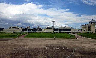
Dimapur Airport is a domestic airport serving Chümoukedima–Dimapur and its neighbouring areas. It is located between the districts of Chümoukedima and Dimapur, from where National Highway 29 passes just beside the airport. It is the only airport in the state of Nagaland. The terminal building can handle 500 departing and 300 arriving passengers, and was built during World War II. There are plans for expansion of the airport to meet international norms by acquiring land at Aoyimti Village.
Konyak is a Sino-Tibetan language spoken by the Konyak people in the state of Nagaland, north-eastern India.
The predominant religion of Nagaland is Christianity. The state's population is 1,978,502, as of 2011, out of which 87.93% are Christians. The 2011 census recorded the state's Christian population at 1,745,181, making it, with Meghalaya, Arunachal Pradesh, and Mizoram as the four Christian-majority states in India. The state has a very high church attendance rate in both urban and rural areas. Huge churches dominate the skylines of Kohima, Chümoukedima, Dimapur and Mokokchung.
National Highway 29 is a primary national highway in India. This highway was previously part of old national highways 36, 39 and 150. Due to rationalisation of national highway numbers of India by Gazette notification on 5 March 2010, it was renumbered as National Highway 29. NH-29 runs across the Indian states of Assam, Nagaland and Manipur. This national highway is 338.5 km (210.3 mi) long.

Viswema is a Southern Angami Naga village in the Kohima District of the Indian state of Nagaland. With a resident population of 7417, it is the second biggest village in the state and is part of the contiguous built-up of the Kohima Metropolitan Area that extends into the neighboring areas of Jakhama, Kigwema and Khuzama in the Southern Angami region, forming the second largest urban agglomerations in Nagaland. Its vast territory also lies across the inter-state boundary in Manipur where notable features including Mount Tempü (Iso) at 9822 feet (2994m) also the highest peak in Manipur, the thick forest of Kezol-tsa and a major portion of the Dzüko Valley is located.

Chümoukedima District is the 15th district of the Indian state of Nagaland. It was created on 18 December 2021. The district is bounded by Kohima District to the east, Peren District to the south, Tseminyü District & Niuland District to the north-east, Dimapur District to the north and Karbi Anglong District of Assam to the west and north-west. The district headquarter is located in the municipality of Chümoukedima.
This is a timeline of the history of the Nagas.
The following outline is provided as an overview of and topical guide to Kohima:
The following is a list of articles relating to the Indian state of Nagaland, sorted in alphabetical order.
Frontier Nagaland is a region of the Indian state of Nagaland. It comprises the eastern districts of Nagaland.
