Santa Ana, California | |
|---|---|
       Top: Santora Building (left) and Santa Ana Regional Transportation Center (right); middle: Santa Ana City Hall (left), West Coast Theatre (center), and high rises (right); bottom: Bowers Museum (left) and Old Santa Ana Courthouse | |
 Flag  Seal Logo | |
| Motto: Education First | |
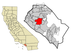 Location of Santa Ana within Orange County, California | |
 Santa Ana Location in the Los Angeles Metropolitan Area  Santa Ana Location in California  Santa Ana Location in the United States  Santa Ana Location in North America | |
| Coordinates: 33°44′27″N117°52′53″W / 33.74083°N 117.88139°W | |
| Country | United States |
| State | California |
| County | Orange |
| Founded | 1869 [1] |
| Incorporated | June 1, 1886 [2] |
| Named after | Saint Anne |
| Area | |
• Total | 27.37 sq mi (70.89 km2) |
| • Land | 27.34 sq mi (70.81 km2) |
| • Water | 0.03 sq mi (0.08 km2) 0.90% |
| Elevation | 115 ft (35 m) |
| Population | |
• Total | 310,227 |
| • Rank | (2023) 3rd in Orange County 14th in California 65th in the United States |
| • Density | 11,000/sq mi (4,400/km2) |
| Time zone | UTC−8 (Pacific) |
| • Summer (DST) | UTC−7 (PDT) |
| Website | santa-ana.org |
The following outline is provided as an overview of and topical guide to English Wikipedia articles about the city of Santa Ana, California.