Ozark, Illinois | |
|---|---|
 Ozark  Ozark | |
| Coordinates: 37°32′33″N88°45′46″W / 37.54250°N 88.76278°W | |
| Country | United States |
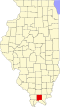
| State | Illinois |
| County | Johnson |
| Elevation | 689 ft (210 m) |
| Time zone | UTC-6 (Central (CST)) |
| • Summer (DST) | UTC-5 (CDT) |
| ZIP code | 62972 |
| Area code | 618 |
| GNIS feature ID | 425295 [1] |
Ozark is an unincorporated community in Johnson County, Illinois, United States. Ozark is south of New Burnside. and has a post office with ZIP code 62972. [2] Ozark is also home to Camp Ondessonk, a Catholic youth camp that is run by the Diocese of Belleville.