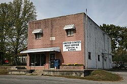
Simpson, Illinois | |
---|---|
Coordinates: 37°28′5″N88°45′23″W / 37.46806°N 88.75639°W | |
Country | United States |
State | Illinois |
County | Johnson |
Area | |
• Total | 0.53 sq mi (1.36 km2) |
• Land | 0.53 sq mi (1.36 km2) |
• Water | 0.00 sq mi (0.00 km2) |
Elevation | 387 ft (118 m) |
Population (2020) | |
• Total | 44 |
• Density | 83.81/sq mi (32.34/km2) |
Time zone | UTC-6 (CST) |
• Summer (DST) | UTC-5 (CDT) |
ZIP code | 62985 |
Area code | 618 |
FIPS code | 17-70005 |
GNIS feature ID | 2399824 [2] |
Wikimedia Commons | Simpson, Illinois |
Simpson is a village in Johnson County, Illinois, United States. The population was 60 at the 2010 census. [3]
Simpson is located in eastern Johnson County at 37°28′5″N88°45′23″W / 37.46806°N 88.75639°W (37.467977, -88.756277), [4] in the valley of Cedar Creek, a south-flowing tributary of Bay Creek and part of the Ohio River watershed. Illinois Route 147 passes through the village, leading southwest 9 miles (14 km) to Vienna, the county seat, and east 5 miles (8 km) to its terminus at Glendale.
According to the 2010 census, Simpson has a total area of 0.531 square miles (1.38 km2), of which 0.53 square miles (1.37 km2) (or 99.81%) is land and 0.001 square miles (0.00 km2) (or 0.19%) is water. [5]
Census | Pop. | Note | %± |
---|---|---|---|
1900 | 187 | — | |
1910 | 161 | −13.9% | |
1920 | 178 | 10.6% | |
1930 | 144 | −19.1% | |
1940 | 172 | 19.4% | |
1950 | 119 | −30.8% | |
1960 | 89 | −25.2% | |
1970 | 82 | −7.9% | |
1980 | 67 | −18.3% | |
1990 | 61 | −9.0% | |
2000 | 54 | −11.5% | |
2010 | 60 | 11.1% | |
2020 | 44 | −26.7% | |
U.S. Decennial Census [6] |
As of the census [7] of 2000, there were 54 people, 21 households, and 17 families residing in the village. The population density was 103.4 inhabitants per square mile (39.9/km2). There were 25 housing units at an average density of 47.9 per square mile (18.5/km2). The racial makeup of the village was 88.89% White, 7.41% African American, 1.85% Native American, 1.85% from other races. Hispanic or Latino of any race were 9.26% of the population.
There were 21 households, out of which 42.9% had children under the age of 18 living with them, 66.7% were married couples living together, 9.5% had a female householder with no husband present, and 19.0% were non-families. 19.0% of all households were made up of individuals, and 4.8% had someone living alone who was 65 years of age or older. The average household size was 2.57 and the average family size was 2.88.
In the village, the population was spread out, with 27.8% under the age of 18, 14.8% from 18 to 24, 22.2% from 25 to 44, 25.9% from 45 to 64, and 9.3% who were 65 years of age or older. The median age was 34 years. For every 100 females, there were 107.7 males. For every 100 females age 18 and over, there were 85.7 males.
The median income for a household in the village was $23,125, and the median income for a family was $41,250. Males had a median income of $16,563 versus $18,125 for females. The per capita income for the village was $13,325. There were no families and 7.0% of the population living below the poverty line, including no under eighteens and none of those over 64.
Woodland is a village in Belmont Township, Iroquois County, Illinois, United States. The population was 324 as of the 2010 census.
Belknap is a village in Johnson County, Illinois, United States. The population was 88 at the 2022 census.
Buncombe is a village in Johnson County, Illinois, United States. The population was 203 at the 2010 census and as of 2018, the population had declined to an estimated 173.
Goreville is a village in Johnson County, Illinois, United States. The population was 1,068 as of the 2020 census, up from 1,049 at the 2010 census.
New Burnside is a village in Johnson County, Illinois, United States. The population was 211 at the 2010 census.
Virgil is a village in Virgil Township, Kane County, Illinois, United States. It was incorporated on November 6, 1990. The population was 329 at the 2010 census, up from 266 in 2000.
Union Hill is a village in Kankakee County, Illinois, United States. The population was 58 at the 2010 census. It is included in the Kankakee-Bradley, Illinois Metropolitan Statistical Area.
Round Lake Heights is a village in Lake County, Illinois, United States. Per the 2020 census, the population was 2,622.
Emington is a village in Livingston County, Illinois, United States. The population was 117 at the 2010 census.
Creston is a village in Ogle County, Illinois, United States. The population was 627 at the 2020 census, down from 662 in 2010.
Eddyville is a village in Pope County, Illinois, United States. The population was 153 at the 2000 census. Two designated wilderness areas, the Burden Falls Wilderness and the Lusk Creek Wilderness, are nearby.
Karnak is a village in Pulaski County, Illinois, United States. The population was 499 at the 2010 census.
Galatia is a village in Saline County, Illinois, in the United States. As of the 2010 census, the village population was 933.
Muddy is a small incorporated village located in the Harrisburg Township in Saline County, Illinois, United States. The population was 78 at the 2000 census.
Stonefort is a village in Saline and Williamson Counties, Illinois, United States. The population was 297 at the 2010 census.
Southern View is a village in Sangamon County, Illinois, United States. The population was 1,642 at the 2010 census. It is part of the Springfield, Illinois Metropolitan Statistical Area.
Rock City is a village in Stephenson County, Illinois. The population was 315 at the 2010 census, up from 313 in 2000.
Pittsburg is a village in Williamson County, Illinois. The population was 572 at the 2010 census.
Spillertown is a village in Williamson County, Illinois, United States. The population was 203 at the 2010 census and as of 2018, the population has grown to an estimated 272.
Tower Lakes is a village in Lake County, Illinois, United States. Per the 2020 census, the population was 1,226.