West Vienna, Illinois | |
|---|---|
 West Vienna  West Vienna | |
| Coordinates: 37°25′43″N88°58′10″W / 37.42861°N 88.96944°W | |
| Country | United States |
| State | Illinois |
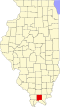
| County | Johnson |
| Elevation | 394 ft (120 m) |
| Time zone | UTC-6 (Central (CST)) |
| • Summer (DST) | UTC-5 (CDT) |
| ZIP code | 62909 |
| Area code | 618 |
| GNIS feature ID | 420941 [1] |
West Vienna, also known as Boles, is an unincorporated community in Johnson County, Illinois, United States. West Vienna is located at the junction of Illinois Route 37 and Illinois Route 146, west of Vienna. West Vienna has a post office with ZIP code 62909, though the post office uses the name Boles. [2]