Tunnel Hill | |
|---|---|
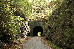 Tunnel Hill, high point and eponym of the Tunnel Hill State Trail | |
 Tunnel Hill Location of Tunnel Hill within Illinois  Tunnel Hill Tunnel Hill (the United States) | |
| Coordinates: 37°31′25″N88°50′19″W / 37.52361°N 88.83861°W | |
| Country | United States |
| State | Illinois |
| County | Johnson |
| Time zone | UTC-6 (CST) |
| • Summer (DST) | UTC-5 (CDT) |
| Postal code | 62972 |
| Area code | 618 |
Tunnel Hill is an unincorporated community in northwestern Johnson County, Illinois. It is best known for its namesake railroad tunnel that gives the name to the Tunnel Hill State Trail, a rails-to-trails project developed by the Illinois Department of Natural Resources.
Municipalities and communities of Johnson County, Illinois, United States | ||
|---|---|---|
| Cities | 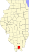 | |
| Villages | ||
| Precincts | ||
| Unincorporated communities | ||
| Footnotes |
| |
| | This Johnson County, Illinois location article is a stub. You can help Wikipedia by expanding it. |