Union County is a county located in the U.S. state of Illinois. According to the 2010 United States Census, it had a population of 17,808. Its county seat is Jonesboro. It is located in the southern portion of Illinois known locally as "Little Egypt".

Saline County is a county located in the U.S. state of Illinois. According to the 2010 census, it had a population of 24,913. Its county seat is Harrisburg. It is located in the southern portion of Illinois known locally as "Little Egypt".

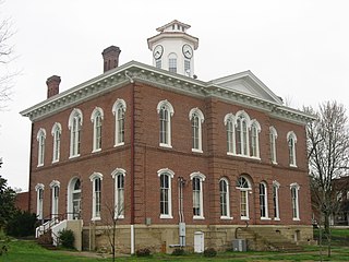
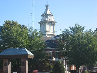
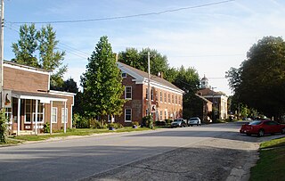
Pope County is a county located in the U.S. state of Illinois. According to the 2010 census, it had a population of 4,470, making it the second-least populous county in Illinois. Its county seat is Golconda. The county was organized in 1816 from portions of Gallatin and Johnson counties and named after Nathaniel Pope, a politician and jurist from the Illinois Territory and State of Illinois.

Mercer County is a county located in the U.S. state of Illinois. According to the 2010 census, it had a population of 16,434. Its county seat is Aledo.

Jackson County is a county located in the U.S. state of Illinois with a population of 60,218 at the 2010 United States Census. Its county seat is Murphysboro, and its most populous city is Carbondale, home to the main campus of Southern Illinois University. The county was incorporated on January 10, 1816 and named for Andrew Jackson. The community of Brownsville served as the fledgling county's first seat.

Hamilton County is a county located in the U.S. state of Illinois. According to the 2010 census, it has a population of 8,457. Its county seat is McLeansboro. It is located in the southern portion of the state known locally as "Little Egypt".

Franklin County is a county located in the U.S. state of Illinois. According to the 2010 census, it has a population of 39,561. Its county seat is Benton. It is located in the southern portion of Illinois known locally as "Little Egypt".
Edwards County is a county located in the U.S. state of Illinois. As of the 2010 census, the population was 6,721. Its county seat is Albion. It is located in the southern portion known locally as "Little Egypt".
Bishop Hill is a village in Henry County, Illinois, United States, along the South Edwards River. The population was 128 at the 2010 census, up from 125 in 2000. It is the home of the Bishop Hill State Historic Site, a park operated by the Illinois Historic Preservation Agency.

Oswego is a village in Kendall County, Illinois, United States. The village population as of the 2010 census was 30,355, more than double its population of 13,326 in 2000. Oswego is the largest municipality located completely within Kendall County.

Campton Hills is a village in Kane County, Illinois and is a far western suburb of Chicago. The population of the village is 11,131 per the 2010 US Census.

Plum Hill is an unincorporated community in Plum Hill Township, Washington County, Illinois, United States. Plum Hill is located along Illinois Route 15, 7.1 miles (11.4 km) west-northwest of Nashville.
West Point is an unincorporated community in Bradley Township, Jackson County, Illinois, United States. The community is located along County Route 1 4.5 miles (7.2 km) west-southwest of Campbell Hill.
Reynoldsburg is an unincorporated community in Johnson County, Illinois, United States. The community is located at the intersection of Gum Springs Road and Reynoldsburg Road 9.6 miles (15.4 km) northeast of Vienna. Reynoldsburg had a post office from 1860 to 1879.
Pond is an unincorporated community in Johnson County, Illinois, United States. The community is located along Illinois Route 147 4.1 miles (6.6 km) east-northeast of Vienna.
Reevesville is an unincorporated community in Johnson County, Illinois, United States. The community is located along County Route 10 and the Canadian National Railroad 11 miles (18 km) east-southeast of Vienna.
Crossroads is an unincorporated community in Johnson County, Illinois, United States. The community is located along County Route 5 6.3 miles (10.1 km) southeast of Vienna.
Ganntown is an unincorporated community in Johnson County, Illinois, United States. The community is located along County Route 10 7.2 miles (11.6 km) east-southeast of Vienna.
Signal Hill is an unincorporated community in Centreville Township, Stookey Township, and the city of Belleville, St. Clair County, Illinois, United States. Signal Hill is located on Illinois Route 157, approximately 11 miles (18 km) southeast of St. Louis, Missouri. Signal Hill dates back to 1904, during the Saint Louis World Fair, when the Signal Hill Park addition was platted. The tree-lined, island separated, boulevard is the centerpiece of the community filled with large, elegant homes dated to the creation of the community.