Santiago, also known as Santiago de Chile, is the capital and largest city of Chile and one of the largest cities in the Americas. It is located in the country's central valley and is the center of the Santiago Metropolitan Region, which has a population of 7 million, representing 40% of Chile's total population. Most of the city is situated between 500–650 m (1,640–2,133 ft) above sea level.

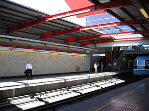
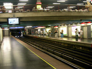
The Santiago Metro is a rapid transit system serving the city of Santiago, the capital of Chile. It currently consists of seven lines, 136 stations, and 140 kilometres (87.0 mi) of revenue route. The system is managed by the state-owned Metro S.A. and is the first and only rapid transit system in the country.

Santa Lucia, is a station on the Santiago Metro in Santiago, Chile. It is underground, between the stations Universidad de Chile and Universidad Católica on the same line. It is located on Avenida Libertador General Bernardo O'Higgins, in the commune of Santiago. The station was opened on 31 March 1977 as part of the extension of the line from La Moneda to Salvador.

Neptuno is a metro station on the Line 1 of the Santiago Metro, in Santiago, Chile. It is located close to the main maintenance facility for the Metro of Santiago. It has a moderate-low flow of passengers, located in a residential place with no big attractions. The station was opened on 15 September 1975 as part of the inaugural section of the line between San Pablo and La Moneda.

Américo Vespucio Avenue is a 64.8-kilometre (40.3 mi) ring road in Santiago, Chile named after Renaissance cartographer Amerigo Vespucci. Two adjacent sections of the avenue are occupied by Vespucio Norte Express and Vespucio Sur free-flow tolling highways, which are under concession. Vespucio Avenue meets the two largest roundabouts in Santiago, namely Quilín and Grecia, which have circumferences of 793 m and 535 m respectively.
Las Rejas is an underground metro station on the Line 1 of the Santiago Metro, in Santiago, Chile. It was built in cut-and-cover method. The station was opened on 15 September 1975 as part of the inaugural section of the line between San Pablo and La Moneda.

República is an underground metro station on the Line 1 of the Santiago Metro, in Santiago, Chile. This station is named for República Avenue. The station was opened on 15 September 1975 as part of the inaugural section of the line between San Pablo and La Moneda.

Santiago Metro Line 1 is the oldest of the seven existing rapid transit lines that make up the Santiago Metro system. Being its busiest, it has a total of 27 stations along its 19.3 km (12.0 mi) length, constructed almost entirely underground, and is located primarily along the axis formed by the Avenida Libertador General Bernardo O'Higgins, Providencia Avenue and Apoquindo Avenue.

Santiago Metro Line 2 is one of the seven rapid transit lines that currently make up the Santiago Metro network in Santiago, Chile. It has 22 stations and 20.7 km (12.9 mi) of track. The line intersects with Line 1 at Los Héroes, with the Line 3 at Puente Cal y Canto, with Line 4A at La Cisterna, with Line 5 at Santa Ana, and Line 6 at Franklin. It will also intersect with the future Line 7 at Puente Cal y Canto. Its distinctive colour on the network line map is banana yellow.

Santiago Metro Line 4 is one of the six lines that currently make up the Santiago Metro network in Santiago, Chile. It has 23 stations and 23.9 km (14.9 mi) of track. The line intersects with Line 1 at Tobalaba, with Line 3 at Plaza Egaña at northeast, and with Line 4A at Vicuña Mackenna and with Line 5 at Vicente Valdés in southeast. It will also intersect with the future Line 8 at Macul. Its distinctive colour on the network line map is blue.

Santiago Metro Line 5 is one of the seven lines that currently make up the Santiago Metro network in Santiago, Chile. It has 30 stations and 29.7 km (18.5 mi) of track. The line intersects with Line 1 at Baquedano station and San Pablo station, with Line 2 at Santa Ana station, with the Line 3 at both Plaza de Armas station and Irarrázaval station, with Line 4 at Vicente Valdés station, and with line 6 at Ñuble station. It will also intersect and the future Line 7 at Baquedano station. Its distinctive colour on the network line map is green.

Protectora de la Infancia station is an elevated metro station located on the overhead section of Line 4 of the Santiago Metro, in Santiago, Chile. It named after the Protectora de la Infancia children's charity, whose headquarters are just opposite the station.

Hospital Sótero del Río station is an elevated metro station located on the overhead section of Line 4 of the Santiago Metro, in Santiago, Chile. It is named after the Sótero del Río Hospital, which is directly surrounding the station. The station is located in Concha y Toro Avenue near its junction with Gabriela Avenue.

Line 3 is a rapid transit line of the Santiago Metro. Traveling from La Reina in the east towards the center, and Quilicura in the North, Line 3 was originally intended to open in the late 1980s, but the 1985 Algarrobo Earthquake hampered its construction, and a subsequent urban explosion in Puente Alto and Maipú further put its construction on hold, until in the early 2010s construction started. The first phase of the project includes 18 stations, which were completed and opened to the public on 22 January 2019. The second phase, composed of a three-station extension towards the main square of Quilicura, should open by 2023. Its distinctive color on the network line map is chocolate brown.
Santiago Metro Line 6 is a line on the Santiago Metro, Santiago, Chile. It connects the commune of Cerrillos, in the south west of the city, with Providencia in the east of the city, where most economic activity is concentrated. It has 10 new stations on 15.3 km (9.5 mi) of track. Its distinctive color on the network line map is purple.

Laguna Sur station is an underground metro station on the Line 5 of Santiago Metro network, in Santiago, Chile. It is located underneath the junction of Teniente Cruz Avenue with Laguna Sur Street, in the commune of Pudahuel between Las Parcelas station and Barrancas station.

Barrancas is an underground metro station on Line 5 of the Santiago Metro network in Santiago, Chile. It is located underneath the junction of Teniente Cruz Avenue and General Bonilla Avenue on the border of the communes of Pudahuel and Lo Prado, between Laguna Sur station and Pudahuel station. It also lies parallel to the Route 68 highway which connects Santiago with Valparaíso and Viña del Mar, and the highway crosses over the underground metro line. The station has disabled access.

Line 7 is a new rapid transit line due to open on the Santiago Metro, in 2027. Intended to relieve the busy Line 1, the Line 7 will start in Renca in the northwest, passing through the city center, before ending in the borders of Las Condes and Vitacura in the northeast. Expected to be finished by 2027, it will add 19 new stations and 24.8 km (15.4 mi) of track to the system. Its distinctive color on the network line map is gray.

Parque Almagro is an underground metro station of Line 3 of the Santiago Metro network, in Santiago, Chile. It is an underground, between the Universidad de Chile and Matta stations on Line 3. It is located at the intersection of San Diego Avenue with Santa Isabel Avenue. The station was opened on 22 January 2019 as part of the inaugural section of the line, from Los Libertadores to Fernando Castillo Velasco.
Hospitales is an underground metro station of Line 3 of the Santiago Metro network, in Santiago, Chile. It is an underground, between the Plaza Chacabuco and Puente Cal y Canto stations on Line 3. It is located at the intersection of Independencia Avenue with Profesor Zañartu Avenue. The station was opened on 22 January 2019 as part of the inaugural section of the line, from Los Libertadores to Fernando Castillo Velasco.