
The Santiago Metro is a rapid transit system serving the city of Santiago, the capital of Chile. It currently consists of seven lines, 136 stations, and 140 kilometres (87.0 mi) of revenue route. The system is managed by the state-owned Metro S.A. and is the first and only rapid transit system in the country.
Curacaví is a city and commune in the Melipilla Province of central Chile's Santiago Metropolitan Region. Its climate is temperate Mediterranean with a long dry season, experiencing high temperatures in summer and low temperatures in winter. Curacaví is located on the Ruta 68 between the coastal conurbation of Viña del Mar and Valparaíso and Santiago which has proved a popular home for expats working in Santiago.
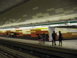
San Pablo is a rapid transit complex in the Santiago Metro, located in Lo Prado. Lines 1 and 5 stop there, being the western terminus of the former.
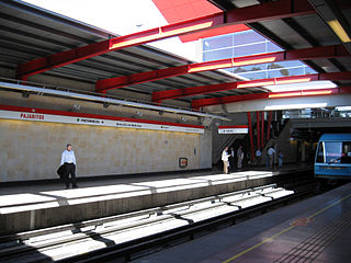
Pajaritos is a metro station on the Line 1 of the Santiago Metro, in Santiago, Chile. Ruta 68 and General Bonilla Avenue run parallel to the station. The station was opened on 15 September 1975 as part of the inaugural section of the line between San Pablo and La Moneda.

Lo Prado is an underground metro station on the Line 5 of the Santiago Metro, in Santiago, Chile. The entrance to the station is located in front of the town hall of Lo Prado. The station was opened on 12 January 2010 as part of the extension of the line from Quinta Normal to Pudahuel.

Monte Tabor is a metro station on the Line 5 of the Santiago Metro, in Santiago, Chile. The station was opened on 3 February 2011 as part of the extension of the line from Pudahuel to Plaza de Maipú. It is one of the three stations built on a viaduct on the just mentioned extension.

Blanqueado is an underground metro station on the Line 5 of the Santiago Metro, in Santiago, Chile. The station was opened on 12 January 2010 as part of the extension of the line from Quinta Normal to Pudahuel.

Plaza de Maipú is an underground metro station on Line 5 of the Santiago Metro, in Santiago, Chile. The station is located under the Plaza de Armas of Maipú. It was formerly the deepest station in the Santiago Metro system at 28 metres (92 ft) deep. However, this has since been surpassed by the Line 3 platforms at Puente Cal y Canto station. The station was opened on 3 February 2011 as the southwestern terminus of the extension of the line from Pudahuel to Plaza de Maipú.

Del Sol is a metro station on the Line 5 of the Santiago Metro, in Santiago, Chile. The station is named for the nearby Autopista del Sol. The station was opened on 3 February 2011 as part of the extension of the line from Pudahuel to Plaza de Maipú.
Santiago Bueras is an underground metro station on the Line 5 of the Santiago Metro, in Santiago, Chile. It is named after Santiago Bueras, a soldier shot dead at the Battle of Maipú. The station was opened on 3 February 2011 as part of the extension of the line from Pudahuel to Plaza de Maipú.

Santiago Metro Line 1 is the oldest of the seven existing rapid transit lines that make up the Santiago Metro system. Being its busiest, it has a total of 27 stations along its 19.3 kilometre length, constructed almost entirely underground, and is located primarily along the axis formed by the Avenida Libertador General Bernardo O'Higgins, Providencia Avenue and Apoquindo Avenue.

Santiago Metro Line 2 is one of the seven rapid transit lines that currently make up the Santiago Metro network in Santiago, Chile. It has 22 stations and 20.7 km of track. The line intersects with Line 1 at Los Héroes, with the Line 3 at Puente Cal y Canto, with Line 4A at La Cisterna, with Line 5 at Santa Ana, and Line 6 at Franklin. It will also intersect with the future Line 7 at Puente Cal y Canto. Its distinctive colour on the network map is banana yellow.
Los Dominicos is a metro station on Line 1 of the Santiago Metro in Santiago, Chile, and is also the eastern terminal of this line.

Santiago Metro Line 5 is one of the seven lines that currently make up the Santiago Metro network in Santiago, Chile. It has 30 stations and 30 km of track. The line intersects with Line 1 at Baquedano station and San Pablo station, with Line 2 at Santa Ana station, with the Line 3 at both Plaza de Armas station and Irarrázaval station, with Line 4 at Vicente Valdés station, and with line 6 at Ñuble station. It will also intersect and the future Line 7 at Baquedano station. Its distinctive colour on the network line map is green.

Santiago Metro Line 4A is one of the seven lines that currently make up the Santiago Metro network in Santiago, Chile. It has six stations and 7.7 km of track. The line intersects with Line 2 at La Cisterna, and with Line 4 at Vicuña Mackenna, both being its termini. It will also intersect with the future Line 9 at Santa Rosa station and acts as a link between these two lines. Its distinctive colour on the network line map is light blue.

Line 3 is a rapid transit line of the Santiago Metro. Traveling from La Reina in the east towards the center, and Quilicura in the North, Line 3 was originally intended to open in the late 1980s, but the 1985 Algarrobo Earthquake hampered its construction, and a subsequent urban explosion in Puente Alto and Maipú further put its construction on hold, until in the early 2010s construction started. The first phase of the project includes 18 stations, which were completed and opened to the public on 22 January 2019. The second phase, composed of a three-station extension towards the main square of Quilicura, should open by 2023. Its color on the map is chocolate.

Laguna Sur station is an underground metro station on the Line 5 of Santiago Metro network, in Santiago, Chile. It is located underneath the junction of Teniente Cruz Avenue with Laguna Sur Street, in the commune of Pudahuel between Las Parcelas station and Barrancas station.

Barrancas is an underground metro station on Line 5 of the Santiago Metro network in Santiago, Chile. It is located underneath the junction of Teniente Cruz Avenue and General Bonilla Avenue on the border of the communes of Pudahuel and Lo Prado, between Laguna Sur station and Pudahuel station. It also lies parallel to the Route 68 highway which connects Santiago with Valparaíso and Viña del Mar, and the highway crosses over the underground metro line. The station has disabled access.

Plaza de Puente Alto is an underground metro station and the southern terminal station of Line 4 of the Santiago Metro network, in Santiago, Chile. The station is located under the square of the same name, Plaza de Puente Alto, parallel to Concha y Toro Avenue at the junction with Manuel Rodríguez avenue in the commune of Puente Alto. The station was opened to the public on November 30, 2005 as part of the inaugural section of the line between Vicente Valdés and Plaza de Puente Alto.

Las Parcelas is a metro station on the Line 5 of the Santiago Metro, in Santiago, Chile. The station was opened on 3 February 2011 as part of the extension of the line from Pudahuel to Plaza de Maipú. It is one of the three stations built on a viaduct on the expansion.


