
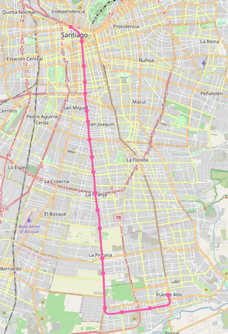
The Santiago Metro is a rapid transit system serving the city of Santiago, the capital of Chile. It currently consists of seven lines, 143 stations, and 149 kilometres (92.6 mi) of revenue route. The system is managed by the state-owned Metro S.A. and is the first and only rapid transit system in the country.

Pantitlán metro station is a Mexico City Metro transfer station in the boroughs of Iztacalco and Venustiano Carranza, in Mexico City. It is a combined underground, at-grade, and elevated station with six island platforms and two side platforms, served by Lines 1, 5, 9, and A. The only quadra-line interchange station in the system, Pantitlán metro station works as the terminal station of all of the lines and is located followed by Zaragoza (Line 1), Hangares (Line 5), Puebla (Line 9), and Agrícola Oriental (Line A) stations. It serves the colonias (neighborhoods) of Ampliación Adolfo López Mateos, Aviación Civil, and Pantitlán; it receives its name from the last one. The station's pictogram features the silhouettes of two flagpoles.

The Bilbao metro is a rapid transit system serving the city of Bilbao and the region of Greater Bilbao. Lines 1 and 2 have a "Y" shape, as they transit both banks of the river Ibaizabal and then combine to form one line that ends in the south of Bilbao. Line 3 has a "V" shape connecting the municipality of Etxebarri with the Bilbao neighbourhood of Matiko; the apex of the "V" is Zazpikaleak/Casco Viejo station, where all three current lines meet. The metro is connected with the Bilbao tram, Bilboko Aldiriak, Euskotren Trena, Feve, Renfe long-distance trains, and Bilbao's bus station. All three lines use metre gauge.

Metrovalencia is an urban rail system serving a large part of the metropolitan area of Valencia. The network is a modern amalgamation of former FEVE narrow gauge electric-operated suburban railways. It is a large suburban network that crosses the city of Valencia, with all trains continuing out to the suburbs. It also has destinations on lines that make it more closely resemble commuter trains. The unique system combines light railway, metro and several tram operations north of the Túria riverbed park with line 4. Trains of lines 1, 3, 5 and 9 have automatic train operation (ATO) in 25.3 kilometers of underground system. Tram lines 4, 6, 8 and 10 are operated by modern trams.

Line 5, also known as the Yellow Line from its color on the system map, is a rapid transit line of the Mexico City Metro network. It travels 15.6 kilometers (9.7 mi) along the boroughs of Gustavo A. Madero, Cuauhtémoc and Venustiano Carranza in northern, northeastern and eastern Mexico City, serving thirteen stations. The line was inaugurated on 19 December 1981, going from Pantitlán to Consulado station. In 1982, the line was expanded twice, first from Consulado to La Raza station on 1 July, and later from La Raza to Politécnico station on 30 August.

Mexico City Metro Line 1 is one of the twelve metro lines operating in Mexico City, Mexico. Officially inaugurated in 1969, it went to become the first metro line to be built in the country. Its identifying color is pink and it runs through the city from west to east.

Line 12, also known as the Golden Line from its color on the system map, is a partially closed rapid transit line of the Mexico City Metro network. It travels 25.1 kilometers (15.6 mi) along the boroughs of Benito Juárez, Iztapalapa and Tláhuac in southwestern, central-southern and southeastern Mexico City, serving twenty stations. The line was inaugurated on 30 October 2012, going from Tláhuac to Mixcoac station. In 2016, work to expand it to Observatorio station started. All the stations are accessible to people with disabilities as they have elevators, tactile pavings and braille signage plates.

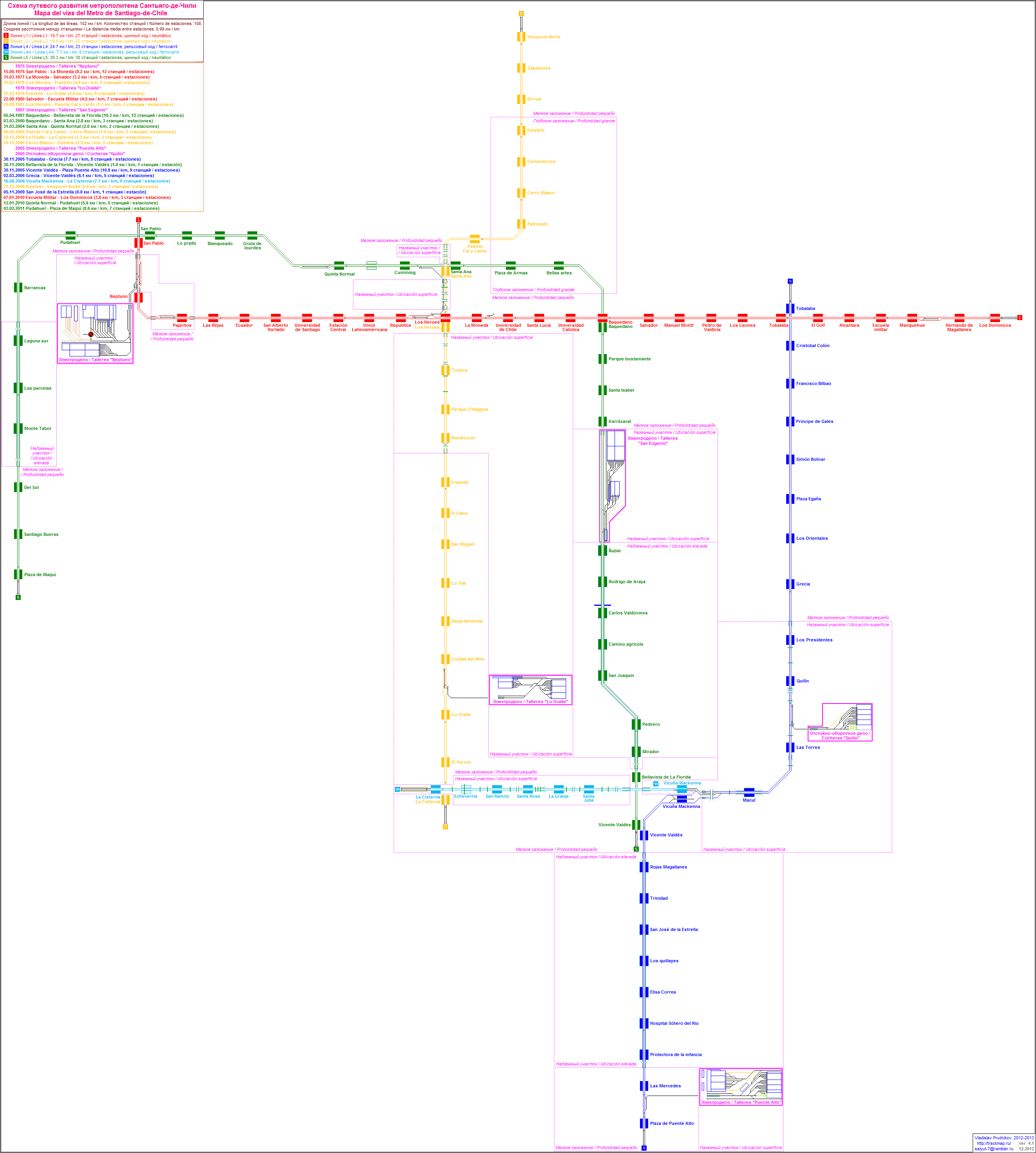
Santiago Metro Line 1 is the oldest of the seven existing rapid transit lines that make up the Santiago Metro system. Being its busiest, it has a total of 27 stations along its 19.3 km (12.0 mi) length, constructed almost entirely underground, and is located primarily along the axis formed by the Avenida Libertador General Bernardo O'Higgins, Providencia Avenue and Apoquindo Avenue.

Santiago Metro Line 2 is one of the seven rapid transit lines that currently make up the Santiago Metro network in Santiago, Chile. It has 26 stations and 25.9 km (16.1 mi) of track. The line intersects with Line 1 at Los Héroes, with the Line 3 at Puente Cal y Canto, with Line 4A at La Cisterna, with Line 5 at Santa Ana, and Line 6 at Franklin. It will also intersect with the future Line 7 and Line 9 at Puente Cal y Canto. Its distinctive colour on the network line map is banana yellow.

Santiago Metro Line 4 is one of the seven lines that currently make up the Santiago Metro network in Santiago, Chile. It has 23 stations and 23.9 km (14.9 mi) of track. The line intersects with Line 1 at Tobalaba, with Line 3 at Plaza Egaña at northeast, and with Line 4A at Vicuña Mackenna and with Line 5 at Vicente Valdés in southeast. It will also intersect with the futures Line 8 at Macul and Line 9 at Plaza de Puente Alto. Its distinctive colour on the network line map is blue.

Santiago Metro Line 5 is one of the seven lines that currently make up the Santiago Metro network in Santiago, Chile. It has 30 stations and 29.7 km (18.5 mi) of track. The line intersects with Line 1 at Baquedano station and San Pablo station, with Line 2 at Santa Ana station, with the Line 3 at both Plaza de Armas station and Irarrázaval station, with Line 4 at Vicente Valdés station, and with line 6 at Ñuble station. It will also intersect and the future Line 7 at Baquedano station. Its distinctive colour on the network line map is green.

Line 3 is a rapid transit line of the Santiago Metro. Traveling from La Reina in the east towards the center, and Quilicura in the North, Line 3 was originally intended to open in the late 1980s, but the 1985 Algarrobo Earthquake hampered its construction, and a subsequent urban explosion in Puente Alto and Maipú further put its construction on hold, until in the early 2010s construction started. The first phase of the project includes 18 stations, which were completed and opened to the public on 22 January 2019 at a cost of US$1.79 billion. The second phase, composed of a three-station extension towards the main square of Quilicura, which was inaugurated on September 25, 2023 with a total project cost of US$378 million. Its distinctive color on the network line map is chocolate brown.
Santiago Metro Line 6 is a line on the Santiago Metro, Santiago, Chile. It connects the commune of Cerrillos, in the south west of the city, with Providencia in the east of the city, where most economic activity is concentrated. It has 10 new stations on 15.3 km (9.5 mi) of track. Its distinctive color on the network line map is purple.

Mexibús is a bus rapid transit (BRT) system that is located in the Greater Mexico City part of the State of Mexico, which surrounds Mexico City proper.

Line 7 is a new rapid transit line due to open on the Santiago Metro, in 2027. Intended to relieve the busy Line 1, the Line 7 will start in Renca in the northwest, passing through the city center, before ending in the borders of Las Condes and Vitacura in the northeast. Expected to be finished by 2028, it will add 19 new stations and 24.8 km (15.4 mi) of track to the system. Its distinctive color on the network line map is gray. Cost of construction has been set at $2.5 billion USD.

Chile España is an underground metro station of Line 3 of the Santiago Metro network, in Santiago, Chile. It is an underground, between the Ñuñoa and Villa Frei stations on Line 3. It is located at the intersection of Irarrázaval Avenue with Chile España Avenue. The station was opened on 22 January 2019 as part of the inaugural section of the line, from Los Libertadores to Fernando Castillo Velasco.

Matta is an underground metro station of Line 3 of the Santiago Metro network, in Santiago, Chile. It is an underground, between the Parque Almagro and Irarrázaval stations on Line 3. It is located at the intersection of Matta Avenue with Santa Rosa Avenue. The station was opened on 22 January 2019 as part of the inaugural section of the line, from Los Libertadores to Fernando Castillo Velasco.
Santiago Metro Line 9 will be a new line that will be part of the Santiago Metro and will have an approximate length of 17 kilometers (11 mi), connecting the communes of Santiago in the center and Puente Alto in the south of the Chilean capital.

The Sistema de Transporte Público Cablebús, simply branded as Cablebús, is an aerial lift transport system that runs in the Gustavo A. Madero and Iztapalapa areas of Mexico City. It is operated by Servicio de Transportes Eléctricos, the agency responsible for the operation of all trolleybus and light rail services in Mexico City. Line 1 was officially inaugurated on 11 July 2021, going from the Indios Verdes station of the STC Metro to the northern neighborhoods of Gustavo A. Madero. Line 2 runs from the Constitución de 1917 to the Santa Marta STC Metro stations in the southeast of the city.

Pueblo Nuevo is a quarter of the City of Temuco, Chile. It is located in the northeast of the city, and corresponds to a residential area, with fragments used as warehouses, workshops, and electrical and transportation infrastructure. Its population was established there in the 1950s, but only in 2000 it was officially defined by the Municipality of Temuco in its Plan de desarrollo comunal. Then, in 2010, in its Diagnóstico sistémico territorial, the Municipality of Temuco modified its limits, transferring part of the territory of the Downtown and Costanera del Cautín Macrosectors, in addition to Ñielol Hill southeastern slopes. A new Territorial Diagnosis returned, in 2014, its original borders, being its current bordering macrosectors Ñielol (west), Costanera del Cautín and Downtown,.


