
Sanhattan, a portmanteau of Santiago and Manhattan, is the popular ironic sobriquet given to Santiago's upscale financial district in Chile's capital. It is located to the northeast of the metropolis, in the western end of the Las Condes commune, nestled between the Mapocho River and Américo Vespucio avenue, encompassing the El Bosque Norte and El Golf barrios. A more narrow definition places it between the intersection of Andrés Bello and Vitacura avenues down to Nueva Los Leones avenue. The central street in Sanhattan is Avenida Apoquindo.

The Santiago Metro is a rapid transit system serving the city of Santiago, the capital of Chile. It currently consists of seven lines, 143 stations, and 149 kilometres (92.6 mi) of revenue route. The system is managed by the state-owned Metro S.A. and is the first and only rapid transit system in the country.
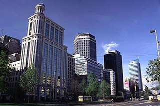
Avenida Libertador General Bernardo O'Higgins, popularly known as La Alameda, is the main avenue of Santiago, Chile. It runs east-west in the centre of the greater urban area and is 7.77 km (4.83 mi) long, and it has up to 5 lanes in each direction. It was named after Chile's founding father Bernardo O'Higgins. It was originally a branch of the Mapocho River.

Américo Vespucio Avenue is a 64.8-kilometre (40.3 mi) ring road in Santiago, Chile named after Renaissance cartographer Amerigo Vespucci. Two adjacent sections of the avenue are occupied by Vespucio Norte Express and Vespucio Sur free-flow tolling highways, which are under concession. Vespucio Avenue meets the two largest roundabouts in Santiago, namely Quilín and Grecia, which have circumferences of 793 m and 535 m respectively.
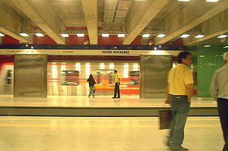
Vicuña Mackenna is a station on the Santiago Metro in Santiago, Chile. It is a transfer station between the Line 4 and the Line 4A and is the eastern terminus of the Line 4A. The Line 4 station was opened on 2 March 2006 as part of the connection between Grecia and Vicente Valdés. The Line 4A station was opened on 16 August 2006 as part of the inaugural section of the line between Vicuña Mackenna and La Cisterna.

Macul is a metro station on the Line 4 of the Santiago Metro, in Santiago, Chile. The station occupies the central viaduct of three adjacent overpasses. The other elevated bridges carry three one-way lanes each of Vespucio Sur. It is located on the site of a former roundabout, where Américo Vespucio Avenue, La Florida Avenue, Macul Avenue and Departamental Avenue used meet. The latter ones currently pass under the aforementioned viaducts, as does a canal called Zanjón de la Aguada. The station was opened on 2 March 2006 as part of the connection between Grecia and Vicente Valdés.
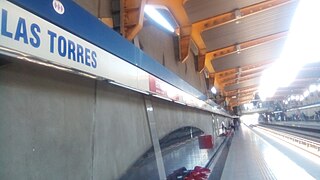
Las Torres is a freeway-median metro station on the Line 4 of the Santiago Metro, in Santiago, Chile. It is built into the median of Vespucio Sur expressway. The station is located immediately north of the cloverleaf interchange of Américo Vespucio Avenue and Las Torres Avenue, which is named so because it features high tension towers along its median. Las Torres Avenue gives its name to the station. The station was opened on 2 March 2006 as part of the connection between Grecia and Vicente Valdés.

La Cisterna is a station on the Santiago Metro in Santiago, Chile. It is an interchange between lines 2 and 4A, and consists of two parts, one built in an open trench and the other partially excavated, joined by pedestrian tunnels. The Line 2 platforms opened on 22 December 2004 as part of a 2.2 km (1.4 mi) southward extension of Line 2 from Lo Ovalle metro station. The Line 4A platforms opened on 16 August 2006 as part of the inaugural section of the line between Vicuña Mackenna and La Cisterna. It is named after La Cisterna, the district where the station is located and whose town hall is close to it.

Avenida Vicuña Mackenna is one of the main transport arteries of Santiago, Chile, joining Santiago center with more remote urban centers such as the communes of La Florida and Puente Alto.

Santiago Metro Line 2 is one of the seven rapid transit lines that currently make up the Santiago Metro network in Santiago, Chile. It has 26 stations and 25.9 km (16.1 mi) of track. The line intersects with Line 1 at Los Héroes, with the Line 3 at Puente Cal y Canto, with Line 4A at La Cisterna, with Line 5 at Santa Ana, and Line 6 at Franklin. It will also intersect with the future Line 7 and Line 9 at Puente Cal y Canto. Its distinctive colour on the network line map is banana yellow.

Santiago Metro Line 4 is one of the seven lines that currently make up the Santiago Metro network in Santiago, Chile. It has 23 stations and 23.9 km (14.9 mi) of track. The line intersects with Line 1 at Tobalaba, with Line 3 at Plaza Egaña at northeast, and with Line 4A at Vicuña Mackenna and with Line 5 at Vicente Valdés in southeast. It will also intersect with the futures Line 8 at Macul and Line 9 at Plaza de Puente Alto. Its distinctive colour on the network line map is blue.

Santiago Metro Line 5 is one of the seven lines that currently make up the Santiago Metro network in Santiago, Chile. It has 30 stations and 29.7 km (18.5 mi) of track. The line intersects with Line 1 at Baquedano station and San Pablo station, with Line 2 at Santa Ana station, with the Line 3 at both Plaza de Armas station and Irarrázaval station, with Line 4 at Vicente Valdés station, and with line 6 at Ñuble station. It will also intersect and the future Line 7 at Baquedano station. Its distinctive colour on the network line map is green.

Santiago Metro Line 4A is one of the seven lines that currently make up the Santiago Metro network in Santiago, Chile. It has six stations and 7.7 km (4.8 mi) of track. The line intersects with Line 2 at La Cisterna, and with Line 4 at Vicuña Mackenna, both being its termini. It will also intersect with the future Line 9 at Santa Rosa station and acts as a link between these two lines. Its distinctive colour on the network line map is light blue.

Line 3 is a rapid transit line of the Santiago Metro. Traveling from La Reina in the east towards the center, and Quilicura in the North, Line 3 was originally intended to open in the late 1980s, but the 1985 Algarrobo Earthquake hampered its construction, and a subsequent urban explosion in Puente Alto and Maipú further put its construction on hold, until in the early 2010s construction started. The first phase of the project includes 18 stations, which were completed and opened to the public on 22 January 2019 at a cost of US$1.79 billion. The second phase, composed of a three-station extension towards the main square of Quilicura, which was inaugurated on September 25, 2023 with a total project cost of US$378 million. Its distinctive color on the network line map is chocolate brown.

San Ramón station is a metro station located on Line 4A of the Santiago Metro in Santiago, Chile between Santa Rosa and La Cisterna station. It lies along the Vespucio Sur Freeway, near its junction with Almirante Latorre Street. The station has disabled access. The station was opened on 16 August 2006 as part of the inaugural section of the line between Vicuña Mackenna and La Cisterna.
Santa Rosa station is an embanked metro station located on Line 4A of the Santiago Metro in Santiago, Chile, between the La Granja and San Ramón stations and also between the communes of the same names La Granja and San Ramón. It lies along the Vespucio Sur Freeway, on its junction with Santa Rosa Avenue. The station was opened on 16 August 2006 as part of the inaugural section of the line between Vicuña Mackenna and La Cisterna.
Santa Julia station is an embanked metro station located on Line 4A of the Santiago Metro in Santiago, Chile, between Vicuña Mackenna station and La Granja station in the commune of La Florida. It lies along the Vespucio Sur Freeway at the junction with Santa Julia Street. The station was opened on 16 August 2006 as part of the inaugural section of the line between Vicuña Mackenna and La Cisterna.
La Granja station is an embanked metro station located on Line 4A of the Santiago Metro in Santiago, Chile. It lies between the Santa Julia and Santa Rosa stations in the commune of the same name, La Granja, and is located along the Autopista Vespucio Sur highway at the junction with Coronel Street. The station was opened on 16 August 2006 as part of the inaugural section of the line between Vicuña Mackenna and La Cisterna.
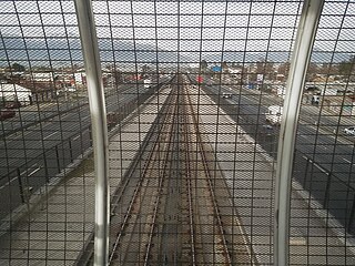
Echeverría is a ghost station that was projected on line 4A of the Santiago Metro. It is located between La Cisterna and San Ramón stations, along the central axis of the Vespucio Sur Freeway, between Blas Vial and María Vial streets in the commune of La Cisterna, specifically at the intersection of Américo Vespucio with Ignacio Echeverría streets and Peró.

Lo Cruzat is an underground metro station of Line 3 of the Santiago Metro network, in Santiago, Chile. It is an underground, between the Plaza Quilicura and Ferrocarril stations on Line 3. It is located at the intersection of Manuel Antonio Matta Avenue with Las Torres and Lo Cruzat Avenues.


