Mangalore, officially known as Mangaluru, is a major industrial port city in the Indian state of Karnataka and on the west coast of India. It is located between the Laccadive Sea and the Western Ghats about 352 km (219 mi) west of Bangalore, the state capital, 14 km north of Karnataka–Kerala border and 297 km south of Goa. Mangalore is the state's only city to have all four modes of transport—air, road, rail and sea. The population of the urban agglomeration was 619,664 according to the 2011 national census of India. It is known for being one of the locations of the Indian strategic petroleum reserves.

Udupi is a city in the Indian state of Karnataka. Udupi is situated about 55 km (34 mi) north of the educational, commercial and industrial hub of Mangalore and more than 400 km west of state capital Bangalore by road.
Dakshina Kannada district is located in the state of Karnataka in India, with its headquarters in the coastal city of Mangalore. It is part of the larger Tulu Nadu region. The district covers an area nestled in between the Western Ghats to its east and the Arabian Sea to its west. Dakshina Kannada receives abundant rainfall during the Indian monsoon. It is bordered by Udupi district to the north, Chikmagalur district to the northeast, Hassan district to the east, Kodagu to the southeast and Kasaragod district of Kerala to the south. According to the 2011 census of India, Dakshina Kannada district had a population of 2,083,625. It is the only district in Karnataka state to have all modes of transport like road, rail, water and air due to the presence of a major hub, Mangalore. This financial district is also known as the Cradle of Indian banking.

Hastinapur is a city in the Meerut district in the Indian state of Uttar Pradesh. Hastinapura, described in Hindu texts such as the Mahabharata and the Puranas as the capital of the Kuru Kingdom, is also mentioned in ancient Jain texts. Hastinapur is located on the right bank of the Ganga river.
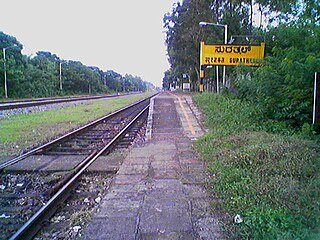
Surathkal is one of the major localities in the northern part of Mangalore city located on National Highway 66 in the Dakshina Kannada district, Karnataka state, India on the shore of Arabian sea. It is a municipality merged with Mangalore City Corporation. It lies between Gurupura (Phalguni) and Pavanje (Nandini) rivers. It is the northern suburb and can be considered as the northernmost area of Mangalore City until Mukka. Surathkal has a railway station on Konkan railway route which connects cities of Mumbai to Mangaluru. Surathkal is 8 km north of New Mangalore seaport, 4 km west of Mangalore Refinery and Petrochemicals Limited and 16 km west of Mangalore International Airport This region has developed educationally, industrially and commercially can be regarded as one of the crucial localities in Mangaluru and coastal Karnataka. The only NIT of Karnataka is situated here which is adjacent to the national highway NH 66. Mukka a popular name in Indian surfing is also situated close to Surathkal. Surathkal beach is well known for its cleanliness and well maintained like other beaches in Mangalore.

Kadri Park is a park located in Kadri Gudde. It is the largest park in Mangalore. This park contains a musical fountain and has hosted the Karavali Utsav. The park is famous for flower shows in Mangalore.

Deralakatte is a major educational, healthcare, commercial and residential locality in the south-eastern part of Mangalore City in the Dakshina Kannada district of Karnataka state. It is 9 km (5.6 mi) away from the Karnataka-Kerala state border. It is popularly known as the University Town owing to its student population and universities. The stretch from Thokottu junction to Konaje is known as the Medical corridor road due to the presence of many premium educational institutions and healthcare facilities. It is close to Mangalore University, Konaje, Mudipu Infosys, Soorya Infratech Park, Thokottu and Ullal. Ullal beach, Someshwar Beach, Pilikula Nisargadhama are some of the nearest tourist destinations. This locality houses the NITTE University, Yenepoya University, Father Muller Charitable Institutions, Fathers Mullers Homeopathic Medical college Hospital and Kanachur Groups of Institutions and Hospital. It is a largest University locality in Mangalore after Manipal university in terms of students from all over the country and other parts of the world.

Kankurgachi is a neighbourhood of North-East Kolkata, in Kolkata district, West Bengal, India. With a cosmopolitan crowd and several commercial buildings and restaurants, Kankurgachi is considered one of the upmarket and elite places in Kolkata. Kankurgachi has become a very important part of Kolkata for its excellent connectivity and infrastructure. Kolkata Airport, Bidhannagar Road railway station, Salt Lake and New Town are close to Kankurgachi.
Kankanadi or Kankanady is one of the major upscale commercial and residential localities of Mangalore city. It houses many highrise buildings and transforming into a highrise hub of Mangalore CBD region along with its major counterparts like Bejai, Kadri, Attavar & Falnir. It is one of the busiest localities of Mangalore.

Hampankatta is the centre of Mangalore City, Karnataka. Hampankatta also called as Happananakatte/Hampankatte/Hampananakatte/Hampanakatte. Most of the public utilities are located here and the locality boasts the most buzzing commercial activity in the city. Hampanakkatte was named by the British in 1920. Its original name was 'Appanakatte'. It was named after a person called Appanna Poojary who constructed a 'well' in the region around 1900, hence it was named Appannakatte. He used to feed his bullock cart etc. in those days and used to take rest.
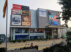
Industrial and commercial activities dominate Mangalore's economy. Mangalore is the only city in the state of Karnataka to have all modes of transport — air, road, rail and sea — as well as being one of only five cities in India to have both a major port and an international airport. Around 75% of India's coffee, timber and cashew nuts exports are handled by the New Mangalore Port. Mangalore International Airport is one of only two international airports in Karnataka; the other being Bangalore's Kempegowda International Airport. Mangalore is the fastest growing non-metropolitan area in South India and the second largest business centre in Karnataka. The city has some of the tallest buildings in South India, with many more under construction.
The Rosario High School, recently renamed as Rosario Composite Pre-university, is a high school in Pandeshwar, Mangalore in the Indian state of Karnataka. The school teaches grades 5 to 12 under the Karnataka Board of Secondary Education and the Karnataka Council of Higher Secondary Education.

Bejai is one of the major localities in Mangalore city, Karnataka, India. The series of Bharath malls, Bharath mall & Bharath mall 2, are located here. It is one of the upscale & the busiest residential cum commercial localities of Mangalore. Bejai - Kadri belt is also regarded as the Manhattan of Mangalore with many high-rise buildings.

Falnir is an upscale commercial and residential locality in Mangalore city, Karnataka, India.
Bondel is a residential locality in Mangalore city, Karnataka, India. It is one of the upscale residential localities of Mangalore. Bondel along with Maryhill houses many highrise buildings and also developing rapidly as a commercial center. It lies in Airport road, which originates in KPT Junction and extends till Mangalore International Airport. Kavoor, one of the major localities of Mangalore is located nearby. This locality is close to the airport too.
Maryhill is a locality in Mangalore city, Karnataka, India. It is one of the upscale residential localities of Mangalore. Maryhill, along with Bondel houses many highrise buildings and is also developing rapidly as a commercial center. Tulu is the main language which is spoken and understood by everyone in this locality. Konkani, Kannada are the other languages that is commonly used. Maryhill is predominantly a residential area and famous for Helipad. Many people use the Helipad daily for morning and evening walk. There are around 10 to 15 youth who enthusiastically gather at Maryhill helipad every Sunday at 8 am to fly their radio controlled aircraft. Instructors in the group train their pupils to fly these aircraft and also to operate radio-controlled motor cars.

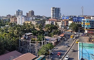
The city of Mangalore is proclaimed as the gateway to Karnataka and lies nestled between the blue waters of the Arabian Sea and the green, towering hills of the Western Ghats. The 184 square km city is spread out over the backwaters of the two rivers, Netravati and Gurpura.