Dakshina Kannada is a district of Karnataka state in India, with its headquarters in the coastal city of Mangalore. It is part of the larger Tulu Nadu region. The district covers an area nestled in between the Western Ghats to its east and the Arabian Sea to its west. Dakshina Kannada receives abundant rainfall during the Indian monsoon. It is bordered by Udupi district to the north, Chikmagalur district to the northeast, Hassan district to the east, Kodagu to the southeast and Kasaragod district of Kerala to the south. According to the 2011 census of India, Dakshina Kannada district had a population of 2,083,625. It is the only district in Karnataka state to have all modes of transport like road, rail, water and air due to the presence of a major hub, Mangalore. This financial district is also known as the Cradle of Indian banking.

Manipal is a Suburb near Udupi, located 5 kilometres from the centre of the city in Udupi district of the state of Karnataka in India and is administered by the Udupi City Municipality. It is located in coastal Karnataka, 62.8 km (39.0 mi). north of Mangalore and 8 km (5.0 mi) east of the Arabian Sea. From its location on a plateau, it commands a panoramic view of the Arabian Sea to the west and the Western Ghats to the east. Manipal got its name from Manipal Lake.

Basaveshwaranagara is a largely residential neighbourhood in the west of Bengaluru, Karnataka, India. It is located to the west of Rajajinagara and is sandwiched between the localities of Mahalakshmi Layout to the north and Vijayanagara to the south, spread across multiple sub-localities, three assembly constituencies and seven Bruhat Bengaluru Mahanagara Palike (BBMP) wards. The area of Basaveshwaranagara is often considered West of Chord Road as it lies to the west of Chord Road, an arterial road in the western part of Bengaluru.
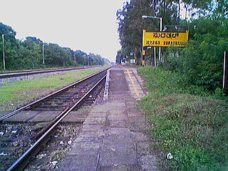
Surathkal is one of the major localities in the northern part of Mangalore city located on National highway 66 in the Dakshina Kannada district, Karnataka state, India on the shore of Arabian sea. It is a municipality merged with Mangalore City Corporation. It lies between Gurupura (Phalguni) and Pavanje (Nandini) rivers. It is the northern suburb & can be considered as the northernmost area of Mangalore City until Mukka. Surathkal has a railway station on Konkan railway route which connects cities of Mumbai to Mangaluru. Surathkal is 8 km north of New Mangalore seaport, 4 km west of Mangalore Refinery & Petrochemicals Limited and 16 km west of Mangalore International Airport This region has developed educationally, industrially & commercially can be regarded as one of the crucial localities in Mangaluru & coastal Karnataka. The only NIT of Karnataka is situated here which is adjacent to the national highway NH 66. Mukka a popular name in Indian surfing is also situated close to Surathkal. Surathkal beach is well known for its cleanliness and well maintained like other beaches in Mangalore.
'Economy of South India after independence in 1947 conformed to a socialist framework, with strict governmental control over private sector participation, foreign trade and foreign direct investment (FDI). Through 1960–1990, South Indian economies experienced mixed economic growth. In the 1960s, Kerala achieved above-average economic growth, while Andhra Pradesh's economy declined during this period. Similarly, Kerala experienced an economic decline in the 1970s while the economies of Tamil Nadu, Andhra Pradesh, and Karnataka consistently exceeded national average growth rates after 1970. Andhra Pradesh, Tamil Nadu and Karnataka were noted by some to be more reform-oriented in terms of economic policy when compared to other Indian states. Over the last decade South India has grown at 8% annually. Future economic growth will be shackled by a relatively low proportion of the active age population to the number of dependents.

Kundapur Vaman Kamath is the former chief of the New Development Bank of BRICS countries, previously he has also served as the Chairman of Infosys Limited, the second-largest Indian IT services company, and as the Non-Executive Chairman of ICICI Bank, India's largest private bank. Kamath also served as ICICI Bank's founder and Managing Director and CEO from 1 May 1996 until his retirement from executive responsibilities on 30 April 2009.

Deralakatte is a major educational, healthcare, commercial & residential locality in the south-eastern part of Mangalore city in Dakshina Kannada district of Karnataka state. It is 9 km (5.6 mi) away from the Karnataka-Kerala state border. It is popularly known as the University Town with more number of student population, universities & the stretch from Thokottu junction to Konaje is also known as the Medical corridor road due to the presence of many premium educational institutions & healthcare facilities where Deralakatte lies in between. It is close to Mangalore University, Konaje, Mudipu Infosys, Soorya Infratech Park, Thokottu & Ullal. Ullal beach, Someshwar Beach, Pilikula Nisargadhama are some of the nearest tourist destinations. This locality houses the NITTE University, Yenepoya University, Father Muller Charitable Institutions, Fathers Mullers Homeopathic Medical college hospital and Kanachur Groups of institutions and Hospital. It is a largest University locality in Mangalore after Manipal university in terms of students from all over the country and other parts of the world.

Hubli and Dharwad are twin cities in the Indian state of Karnataka. Hubli-Dharwad form the second-largest municipality of Karnataka in terms of area, after capital Bangalore and second largest city after Bangalore. Hubli–Dharwad makes up for the second largest urban agglomeration in the state after Bangalore. While Dharwad is the administrative headquarters, the city of Hubli, situated about 20 km (12 mi) south-east of Dharwad, is the commercial centre and business hub of North Karnataka. The cities have a single municipal corporation called Hubli-Dharwad Municipal Corporation (HDMC).

Mangalore University commonly known as, MU is a public university in Konaje, Mangaluru, Karnataka, India. In 2021, National Assessment and Accreditation Council (NAAC) awarded Mangalore University 'B' grade.
Thokottu is a commercial junction to the south of Mangalore city on National Highway 66 and the gateway to Mangalore city from the South (Kerala). It is one of the major and busiest junctions of Mangalore city wherein one road goes towards east to Deralakatte and Konaje, educational hubs with several premium educational institutions and few information technology companies, the other road towards west goes to Ullal. This junction connects Mangalore city, second major city of Karnataka with Talapady and Kerala. A flyover is constructed in the junction to reduce the congestion for the travellers travelling between Mangalore city and Kerala. The creation of educational institutions in Deralakatte and Konaje has led to the construction of many commercial complexes in the area.
Kankanadi or Kankanady is one of the major upscale commercial and residential localities of Mangalore city. It houses many highrise buildings and transforming into a highrise hub of Mangalore CBD region along with its major counterparts like Bejai, Kadri, Attavar & Falnir. It is one of the busiest localities of Mangalore.
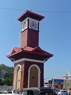
Hampankatta is the centre of Mangalore City, Karnataka. Hampankatta also called as Happananakatte/Hampankatte/Hampananakatte/Hampanakatte. Most of the public utilities are located here and the locality boasts the most buzzing commercial activity in the city. Hampanakkatte was named by the British in 1920. Its original name was 'Appanakatte'. It was named after a person called Appanna Poojary who constructed a 'well' in the region around 1900, hence it was named Appannakatte. He used to feed his bullock cart etc. in those days and used to take rest.

Pandeshwar is a residential and commercial locality in the city of Mangalore, Karnataka, India. It is one of the upscale residential, commercial & financial centres of Mangalore. It houses some of the highrise buildings and many more under pipeline. It is close to Mangaladevi Temple, which is one of the well known temples of Mangalore. It is just half a mile away from the Mangalore Central railway station, Mangalore City Bus Stand and Nehru Maidan. Pandeshwar is surrounded by Hoige Bazaar, Yemmekere & State Bank.

Bearys Institute of Technology (BIT) is a private technical co-educational college located in Lands End, Inoli, Karnataka, India, near Mangalore. Founded by The Bearys Group under the aegis of Bearys Academy of Learning and was established in 2009. It is affiliated to the Visvesvaraya Technological University, Belgaum.
Kulur or Kuloor is a locality in Mangalore city, Karnataka, India. Kulur is one of the major commercial junctions in the city. It is the gateway of Mangalore City South. To the north there is Gurupura river. It connects the northern parts of city like Surathkal, Kulai, Baikampady, Panambur to the eastern parts like Airport, Bajpe, Kavoor, Bondel, Maryhill, Vamanjoor & to the southern parts like Kottara, Bejai, MG Road, Statebank, Pumpwell, Thokottu, Ullal, Deralakatte, Konaje. The River Festival of Mangalore was held at Kulur along with Bangrakulur & Tannirbhavi. The district administration & Mangalore City Corporation proposed of building a permanent jetty at Kulur, to promote the backwater tourism of Mangalore along Gurupura River. The Kulur-Tannirbhavi corridor will be developed as a major tourists attraction under the Smart City Project.

Bondel is a residential locality in Mangalore city, Karnataka, India. It is one of the upscale residential localities of Mangalore. Bondel along with Maryhill houses many highrise buildings and also developing rapidly as a commercial center. It lies in Airport road, which originates in KPT Junction and extends till Mangalore International Airport. Kavoor, one of the major localities of Mangalore is located nearby. This locality is close to the airport too.
Maryhill is a locality in Mangalore city, Karnataka, India. It is one of the upscale residential localities of Mangalore. Maryhill, along with Bondel houses many highrise buildings and is also developing rapidly as a commercial center. Tulu is the main language which is spoken and understood by everyone in this locality. Konkani, Kannada are the other languages that is commonly used. Maryhill is predominantly a residential area and famous for Helipad. Many people use the Helipad daily for morning and evening walk. There are around 10 to 15 youth who enthusiastically gather at Maryhill helipad every Sunday at 8 am to fly their radio controlled aircraft. Instructors in the group train their pupils to fly these aircraft and also to operate radio-controlled motor cars
Panambur Beach is a beach in the city of Mangalore in the Indian state of Karnataka.

NITK Beach is situated in Surathkal, the northern part of Mangalore city, Karnataka. This beach is also known as Surathkal beach. It is a private beach that was later named after the nearby NITK.
Sasihithlu beach also known as Daibittil beach is located in Sasihithlu village, which is situated north of Mangalore city, in the state of Karnataka, in India. Sasihithlu Beach is situated approximately 6 km to the west of NH 66, and surrounded by the backwaters of the Pavanje and Shambhavi rivers. The two rivers meet at the beach. It is close to Mukka, one of the fastest developing localities of Mangalore. This beach hosted the Indian Open of Surfing in 2016 and 2017.

