
Bantwal(ಉಚ್ಚಾರಣೆːlisten ) is a taluk in Dakshina Kannada district, Karnataka, India. It is located 25 km (16 mi) East of Mangalore city center. BC Road-Kaikamba of Bantwal is one of the fastest developing areas in Dakshina Kannada district of Karnataka. Along with BC Road-Kaikamba, Panemangalore & Melkar regions are also urbanized. They are also developing as the eastern suburbs of Mangalore. Towards east of Mangalore, the stretch upto BC Road-Kaikamba region forms a continuous Mangalore Urban Agglomeration area which is currently the second biggest in Karnataka after Bangalore. Bantwal is the fourth largest urban area in Dakshina Kannada district after Mangalore, Ullal & Puttur in terms of population.
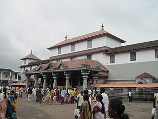
Dharmasthala is an Indian temple town on the banks of the Nethravathi River in the Belthangady taluk of the Dakshina Kannada district in Karnataka, India. It is a panchayat village, and it is the only village in its gram panchayat.

Kokradi (Kokrady) is an agricultural village in Dakshina Kannada of Karnataka State in India. Administratively, it is under Andinje gram panchayat, Belthangadi Taluk, Dakshina Kannada. Kokradi is also used as a surname among the Chitrapur, Saraswat, and Brahmins from the village.
Naravi is a panchayat village in Belthangady taluk, Dakshina Kannada in the foothills of the Western Ghats. There are two villages in the Naravi gram panchayat: Naravi and Kuthluru. It is 58 km from Mangalore and 20 km from Karkala towards Dharmasthala. Naravi is known for Sri Sooryanarayana temple which is one of the two well known Sun temples, the other of which is located at Konark. This name came because of "Naa Ravi" in Kannada means no visible Sun light because forest at day time. It also has Sri Veenugopalakrishna Temple, which has a beautiful idol of Krishna carrying a child in his hands. Those who don't have children come to this statue of Krishna to pray for children.

Badiyadka officially known as "Badiadka" is a town and gram panchayat in the Kasaragod district, state of Kerala, India.
Addur is a village in the southern state of Karnataka, India. It is located in the Mangalore taluk of Dakshina Kannada district.
Aletty is a village in the southern state of Karnataka, India. It is located in the Sullia taluk of Dakshina Kannada district in Karnataka.
Amtady is a village in the southern state of Karnataka, India. It is located in the Bantwal taluk of Dakshina Kannada district in Karnataka.
Golthamajal is a village in the southern state of Karnataka, India. It is located in the Bantwal taluk of Dakshina Kannada district in Karnataka. It is situated at a distance of 34 km towards the east of Mangalore city.
Kanyana is a village in the southern state of Karnataka, India. It is located in the Bantwal Taluk of Dakshina Kannada district in Karnataka. The majority of the population are Hindus, Catholics and Muslims and the main languages spoken are Tulu, Kannada, Beary, Malayalam and Konkani.
Kuvettu is a census town in the southern state of Karnataka, India. Administratively it is under Beltangadi taluk of Dakshina Kannada district in Karnataka.
Manchi is a village in the southern state of Karnataka, India. The village has most of the lands under agriculture. Over 90% of people are literate. nearest town is B.C Road which is 12 km from Manchi. In Manchi there is a primary school established in 1950 and another highschool. Roads connect B.C Road, Vitla, Mangalore and Kalladka. It is located in the Bantwal taluk of Dakshina Kannada district in Karnataka. The office of the Grampanchayath is in "Kukkaje".
Manjanady is a village in the Indian state of Karnataka, India. It is located in the Mangalore taluk of Dakshina Kannada district in Karnataka.
Thiruvail is a village in the southern state of Karnataka, India. It is located in the Mangalore taluk of Dakshina Kannada district.
Ira is a village in the southern state of Karnataka, India. It is located in the Bantwal taluk of Dakshina Kannada district in Karnataka. Ira is situated at a distance of 30 km from Mangalore city. Ira is a showcase gram panchayat known for its cleanliness, sanitation and development projects. KIADB is planning a 700 acres (2.8 km2) small scale industrial park in Ira. This includes a Textile Park of 300 acres (1.2 km2).
Mangalore taluk is a taluk (subdistrict) in the Dakshina Kannada district, Karnataka on the western coast of India. Mangalore is the administrative headquarters of the taluk. It is made up of Mangalore City Corporation, Ullal City Municipality that govern the Mangalore Urban Agglomeration, Other than these there are forty-nine panchayat villages in Mangalore taluk. It covers an area of 834 square kilometres (322 sq mi). Mangalore, Ullal and Moodabidri are the top 3 highly populated towns.#surya4k2
Puttur Taluk is a taluka in Dakshina Kannada district of the Indian state of Karnataka. The headquarters is the town of Puttur. There are thirty-seven Panchayat villages in Puttur Taluka.
Patrame is a small, rural panchayat village on the left (east) bank of the Netravati River in Karnataka, India. Administratively, it is under Belthangady taluk, Dakshina Kannada district, Karnataka. Patrame is the only village in its gram panchayat. The village of Patrame is 26 km from its taluk headquarters Belthangady, and 8 km by road from Dharmasthala.
Yedapadavu is a former village (township) in Mangalore taluk, Karnataka, India, that was divided into Badagayedapadavu and Tenkayedapadavu. Yedapadavu now gives its name, as "Yedapadav" to the gram panchayat for those two villages. The village of Tenkayedapadavu is the main village for the gram panchayat, and is sometimes called "Yedapadavu". Yedapadavu was affected by the 2008 attacks on Christians in southern Karnataka. The gram panchayat is about 21 km northeast of the city of Mangalore, connected via NH 169 .bh
Kambagi is a panchayat village in the southern state of Karnataka, India. Administratively it is under Vijayapur Taluk of Vijayapur District, Karnataka. It is nearly 40 kilometres (25 mi) from district headquarters, the city of Vijayapur, Karnataka. Kambagi has Government Primary HealthCare Center, Post Office, Bank of India and Gram Panchayat offices.

