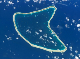
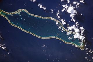
Paparara is a village on Aratika atoll. It is 3 km SE of Aratika Airport and 15 km NE of Aratika-Perles Airport. [1] [2]
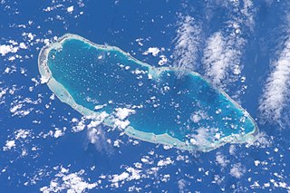
Aratika is an atoll in the Tuamotu group in French Polynesia. The nearest land is Kauehi Atoll, located 35 km to the south east.
Paparara is a village on Aratika atoll. It is 3 km SE of Aratika Airport and 15 km NE of Aratika-Perles Airport. [1] [2]
Aratika is an atoll in the Tuamotu group in French Polynesia. The nearest land is Kauehi Atoll, located 35 km to the south east.

The Northwestern Hawaiian Islands or the Leeward Islands are the small islands and atolls in the Hawaiian island chain located northwest of the islands of Kauai and Niihau. Politically, they are all part of Honolulu County in the U.S. state of Hawaii, except Midway Atoll, which is a territory distinct from Hawaii and grouped as one of the United States Minor Outlying Islands. The United States Census Bureau defines this area, except Midway, as Census Tract 114.98 of Honolulu County. Its total land area is 3.1075 square miles (8.048 km2). All the islands except Nihoa are north of the Tropic of Cancer, making them the only islands in Hawaii that lie outside the tropics.

Puka-Puka is a small coral atoll in the north-eastern Tuamotu Archipelago, sometimes included as a member of the Disappointment Islands. This atoll is quite isolated, the nearest land being Fakahina, located 182 km to the southwest.
Napuka, or Pukaroa, is a small coral atoll in the Disappointment Islands, in the northeastern part of the Tuamotu Archipelago in French Polynesia. It is located only 15 km to the southeast of Tepoto Nord, its nearest neighbor, forming a small group. These two atolls are quite isolated, the nearest land being Fangatau Atoll 170 km to the south.

Rangiroa or Te Kokōta, is the largest atoll in the Tuamotus, and one of the largest in the world. It is part of the Palliser group. The nearest atoll is Tikehau, 12 km to the west. It is about 355 km northeast of Tahiti.
Manihi, or Paeua, is a coral atoll in the Tuamotu Archipelago, part of French Polynesia. It is one of the northernmost of the Tuamotus, located in the King George subgroup. The closest land to Manihi is Ahe Atoll, located 14 km to the west. The population is 650 inhabitants.

Hao, or Haorangi, is a large coral atoll in the central part of the Tuamotu Archipelago. It has c. 1000 people living on 35 km². It was used to house the military support base for the nuclear tests on Mururoa. Because of its shape, French explorer Louis Antoine de Bougainville named it "Île de la Harpe".
Apataki is a coral atoll in the South Pacific Ocean, territorially part of French Polynesia. It is one of the Palliser Islands, a subgroup of the Tuamotu Archipelago. Apataki is located approximately 370 kilometres northeast of the island of Tahiti, 17 km (11 mi) east of Arutua and 24 km (15 mi) northeast of Kaukura. The island is approximately rectangular; it is 34 km (21 mi) long and 24 km (15 mi) wide. It has a total area of approximately 706 km2 with a land area of approximately 21 km2 (8 sq mi). Its wide lagoon has two navigable passes to enter it.

Anaa, Nganaa-nui is an atoll in the Tuamotu archipelago, in French Polynesia. It is located in the north-west of the archipelago, 350 km to the east of Tahiti. It is oval in shape, 29.5 km in length and 6.5 km wide, with a total land area of 38 km² and a population of 504. The atoll is made up by eleven small barren islands with deeper and more fertile soil than other atolls in the Tuamotus. The lagoon is shallow, without entrance, and formed by three main basins. Although it does not have any navigable access, the water of the lagoon renews by several small channels that can be crossed walking.
Totegegie Airport is an airport on Totegegie Island, French Polynesia. It is 9 km northeast of the village of Rikitea.
Tureia is an atoll in the Tuamotu Archipelago in French Polynesia.
Niau is a small atoll in French Polynesia, in the commune of Fakarava. This atoll has a broad fringing reef, a diameter of 8 km and an area of 53 km².

Makemo, Rangi-kemo or Te Paritua, is one of the larger of the Tuamotu atolls in French Polynesia.

Arutua, or Ngaru-atua is an atoll in the Tuamotu group in French Polynesia. It is located 40 km SW of Rangiroa. The closest land is Apataki Atoll, only 16 km to the East.
Fangatau, or Nakai-erua, is a small atoll in the Tuamotu group in French Polynesia. The nearest land is Fakahina Atoll, located 72 km to the ESE. This small atoll has an elongated shape. Its length is 8 kilometres, maximum width 3.5 kilometres. It has a total area of 22.2 square kilometres, land area 5.9 km2. Its reef encloses its lagoon completely. Anchorage is difficult. Fangatau Atoll has 135 inhabitants. Teana is the main village.
Takaroa, Taka-roa or Takapua, is an atoll in the Tuamotu group in French Polynesia. It has a length of 27.4 kilometres and a width of 7 km (4 mi); its land area is 20 square kilometres.
Kaukura or Kaheko is an atoll in the Tuamotu group in French Polynesia, 48 km (30 mi) long and 15 km (9 mi) wide. It is located in the western area of the archipelago, 58 km (36 mi) SW of Rangiroa. The closest land is Arutua Atoll, only 16 km (10 mi) to the East.

Takume or Pukamaru is an atoll of the Tuamotus chain in French Polynesia, located 790 km northeast of Tahiti and 6 km northeast of Raroia and 128 kilometres to the west of Fangatau.
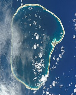
Kauehi, or Putake, is an atoll in the Tuamotu group in French Polynesia. The nearest land is Raraka Atoll, located 17 km to the Southeast.

Raraka, or Te Marie, is an atoll in the west of the Tuamotu group in French Polynesia. It lies 17 km to the southeast of Kauehi Atoll.
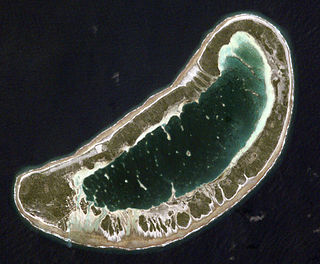
Aratika (15°27'S., 145°30'W.), an atoll about 8 miles in diameter, is wooded on the N side, with a low, dangerous reef everywhere else. ... The pass provides access to the village of Paparara, which is readily visible from a distance.
Tuamotus Gambiers | Islands/Atolls | ||
|---|---|---|---|
| Island groups | |||
Coordinates: 15°30′32″S145°27′18″W / 15.509°S 145.455°W

A geographic coordinate system is a coordinate system that enables every location on Earth to be specified by a set of numbers, letters or symbols. The coordinates are often chosen such that one of the numbers represents a vertical position and two or three of the numbers represent a horizontal position; alternatively, a geographic position may be expressed in a combined three-dimensional Cartesian vector. A common choice of coordinates is latitude, longitude and elevation. To specify a location on a plane requires a map projection.
| This French Polynesia-related geography article is a stub. You can help Wikipedia by expanding it. |