
Monroe County is a county on the northeast border of the U.S. state of Mississippi next to Alabama. As of the 2020 census, the population was 34,180. Its county seat is Aberdeen.

Ouachita Parish is located in the northern part of the U.S. state of Louisiana. As of the 2020 census, the population was 160,368. The parish seat is Monroe. The parish was formed in 1807.
Hamilton is a census-designated place and unincorporated community in Monroe County, Mississippi, United States. As of the 2020 census, it had a population of 404.

Athens is an unincorporated community in Monroe County, Mississippi.
Becker is an unincorporated community in Monroe County, Mississippi.
Gibson is an unincorporated community in Monroe County, Mississippi. Gibson is located west of Aberdeen on Mississippi Highway 8.
Greenwood Springs is an unincorporated community in Monroe County, Mississippi. Greenwood Springs is located east of Amory on U.S. Route 278.
Quincy is an unincorporated community in Monroe County, Mississippi, United States.
Bigbee is an unincorporated community in Monroe County, Mississippi. Bigbee is located northwest of Amory on Mississippi Highway 6 (close to its intersection with Mississippi Highway 371.
Splunge,, is an unincorporated community in Monroe County, Mississippi.
Wren,, is an unincorporated community in Monroe County, Mississippi.
Strong is an unincorporated community in Monroe County, Mississippi, United States.
Binford is an unincorporated community in Monroe County, Mississippi. Binford is located southwest of Aberdeen.
Wise Gap,, is an unincorporated community in Monroe County, Mississippi, United States.
Muldon, also known as Aberdeen Junction, Loohattan, Loohatten and Louhatten, is an unincorporated community in Monroe County, Mississippi. Muldon is located southwest of Aberdeen on Mississippi Highway 25.
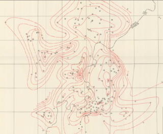
Jackson Volcano is an extinct volcano 2,900 feet (880 m) beneath the city of Jackson, Mississippi, under the Mississippi Coliseum. The uplifted terrain around the volcano forms the Jackson Dome, an area of dense rock clearly noticeable in local gravity measurements. E.W. Hilgard published his theory of an anticline beneath Jackson in 1860 due to his observations of surface strata. The dome contains relatively pure carbon dioxide which is used in oil production in Gulf Coast oil fields. The noble gas data suggests mantle origins with a date of 70 million years for the Jackson Dome intrusion. Geologists have evidence of repeated uplifts accompanied by dike intrusions and volcanic extrusions, erosion, and sedimentation with one coral reef having developed during a submergence. Much of the oil at the crest of the dome volatilized during a late uplift, but oil production wells numbered over a hundred in 1934.
Tinsley is an unincorporated community located in Yazoo County, Mississippi, United States. Tinsley is approximately 11 miles (18 km) south of Yazoo City and 4 miles (6.4 km) North of Oil City near U.S. Route 49.
Peeltown is an unincorporated community in Kaufman County, located in the U.S. state of Texas.
Beans Ferry is an unincorporated community in Itawamba County, Mississippi, United States. It is located on Mississippi Highway 25, 4.5 mi (7.2 km) south of Fulton. The Mississippian Railway passes through Beans Ferry.
Bolivar is a ghost town located in Monroe County, Mississippi, United States.


