Gattman, Mississippi

Last updated

Gattman, Mississippi
US278 East - Gattman Sign (41644716812).jpg
Monroe County Mississippi Incorporated and Unincorporated areas Gattman Highlighted.svg
Location in Monroe County and the state of Mississippi
Usa edcp location map.svg
Red pog.svg
Gattman, Mississippi
Location in the United States
Coordinates: 33°53′6″N88°14′1″W / 33.88500°N 88.23361°W / 33.88500; -88.23361
Country United States
State Mississippi
County Monroe
Area
[1]
  Total0.56 sq mi (1.46 km2)
  Land0.56 sq mi (1.46 km2)
  Water0.00 sq mi (0.00 km2)
Elevation
299 ft (91 m)
Population
 (2020) [2]
  Total77
  Density137.01/sq mi (52.87/km2)
Time zone UTC-6 (Central (CST))
  Summer (DST) UTC-5 (CDT)
ZIP codes
38844 (Gattman)
39740 (Caledonia)
Area code 662
FIPS code 28-26780
GNIS feature ID0670338

Gattman is a village in Monroe County, Mississippi. The population was 77 at the 2020 census, [2] down from 90 in 2010.

Contents

Geography

Gattman is located in eastern Monroe County at 33°53′6″N88°14′1″W / 33.88500°N 88.23361°W / 33.88500; -88.23361 (33.885085, -88.233477). [3] It is bordered to the east by the state of Alabama. U.S. Route 278 passes through the village, leading northwest 17 miles (27 km) to Amory and east 6 miles (10 km) to Sulligent. Aberdeen, the Monroe county seat, is 20 miles (32 km) to the southwest via US 278 and Mississippi Highway 8.

According to the U.S. Census Bureau, the village of Gattman has a total area of 0.56 square miles (1.5 km2), all land. [1] The Buttahatchee River passes just north of the village limits, flowing west and then south to join the Tombigbee River near Columbus Air Force Base.

Demographics

Historical population
CensusPop.Note
1900 111
1910 15539.6%
1920 151−2.6%
1930 1584.6%
1940 18617.7%
1950 150−19.4%
1960 145−3.3%
1970 17520.7%
1980 151−13.7%
1990 120−20.5%
2000 114−5.0%
2010 90−21.1%
2020 77−14.4%
U.S. Decennial Census [4]

As of the census [5] of 2000, there were 114 people, 50 households, and 34 families residing in the village. The population density was 202.8 inhabitants per square mile (78.3/km2). There were 53 housing units at an average density of 94.3 per square mile (36.4/km2). The racial makeup of the village was 95.61% White and 4.39% African American.

There were 50 households, out of which 22.0% had children under the age of 18 living with them, 54.0% were married couples living together, 10.0% had a female householder with no husband present, and 32.0% were non-families. 32.0% of all households were made up of individuals, and 10.0% had someone living alone who was 65 years of age or older. The average household size was 2.28 and the average family size was 2.79.

In the village, the population was spread out, with 16.7% under the age of 18, 9.6% from 18 to 24, 21.9% from 25 to 44, 35.1% from 45 to 64, and 16.7% who were 65 years of age or older. The median age was 46 years. For every 100 females, there were 86.9 males. For every 100 females age 18 and over, there were 86.3 males.

The median income for a household in the village was $35,357, and the median income for a family was $37,000. Males had a median income of $27,083 versus $18,750 for females. The per capita income for the village was $15,533. There were no families and 2.2% of the population living below the poverty line, including no under eighteens and 11.8% of those over 64.

Education

Gattman is served by the Monroe County School District. [6]

Related Research Articles

<span class="mw-page-title-main">Clay County, Mississippi</span> County in Mississippi, United States

Clay County is a county in the U.S. state of Mississippi. As of the 2020 census, the population was 18,636. Its county seat is West Point. Its name is in honor of American statesman Henry Clay, member of the United States Senate from Kentucky and United States Secretary of State in the 19th century. J. Wesley Caradine, an African American, was the first state representative for Clay County after it was established in 1871.

<span class="mw-page-title-main">Lamar County, Alabama</span> County in Alabama, United States

Lamar County is a county in the U.S. state of Alabama. As of the 2020 census, the population was 13,972. Its county seat is Vernon and it is a dry county. It is named in honor of Lucius Quintus Cincinnatus Lamar, a former Confederate officer and former member of both houses of the United States Congress from Mississippi.

<span class="mw-page-title-main">Monroe County, Mississippi</span> County in Mississippi, United States

Monroe County is a county on the northeast border of the U.S. state of Mississippi next to Alabama. As of the 2020 census, the population was 34,180. Its county seat is Aberdeen.

<span class="mw-page-title-main">Itawamba County, Mississippi</span> County in Mississippi, United States

Itawamba County is a county located in the U.S. state of Mississippi. As of the 2020 United States Census, the population was 23,863. Its county seat is Fulton. The county is part of the Tupelo, MS Micropolitan Statistical Area.

<span class="mw-page-title-main">Alcorn County, Mississippi</span> County in Mississippi, United States

Alcorn County is a county located in the northeastern portion of the U.S. state of Mississippi. As of the 2020 census, the population was 34,740. Its county seat is Corinth. The county is named in honor of Governor James L. Alcorn.

<span class="mw-page-title-main">Gulfport, Illinois</span> Village in Illinois, United States

Gulfport is a village in Henderson County, Illinois, United States. As of the 2010 census, the village population was 54, down from 207 at the 2000 census. It is part of the Burlington, IA–IL Micropolitan Statistical Area. The village was completely submerged, save the roofs of some homes and buildings, by a levee break during the flood of 2008.

<span class="mw-page-title-main">Gorham, Illinois</span> Village in Illinois, United States

Gorham is a village in Jackson County, Illinois, United States. The population was 236 at the 2010 census. It is known locally for its near-annihilation during the deadly Tri-State Tornado of 1925.

<span class="mw-page-title-main">Fults, Illinois</span> Village in Illinois, United States

Fults is a village in the Renault precinct of Monroe County, Illinois, United States. The population was 28 at the 2020 census. It is located entirely within the American Bottom floodplain of the Mississippi River.

<span class="mw-page-title-main">Maeystown, Illinois</span> Village in Illinois, United States

Maeystown is a village in Monroe County, Illinois, United States. The population was 150 at the 2020 census.

<span class="mw-page-title-main">Valmeyer, Illinois</span> Village in Illinois, United States

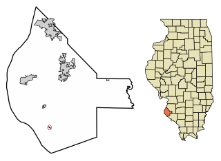
Valmeyer is a village in Monroe County, Illinois, United States. The population was 1,233 at the 2020 census. It was originally located in the American Bottom floodplain of the Mississippi River but now occupies higher land to the east.

<span class="mw-page-title-main">Sobieski, Minnesota</span> City in Minnesota, United States

Sobieski is a city in Morrison County, Minnesota, United States. The population was 210 at the 2020 census.

<span class="mw-page-title-main">Hatley, Mississippi</span> Town in Mississippi, United States

Hatley is a town in Monroe County, Mississippi. The population was 495 at the 2020 census.

<span class="mw-page-title-main">Smithville, Mississippi</span> Town in Mississippi, United States

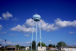
Smithville is a town in Monroe County, Mississippi, United States. The population was 509 at the 2020 census, down from 942 in 2010.

<span class="mw-page-title-main">Clarington, Ohio</span> Village in Ohio, United States

Clarington is a village in Monroe County, Ohio, United States, along the Ohio River. The population was 280 at the 2020 census.

<span class="mw-page-title-main">Bettsville, Ohio</span> Village in Ohio, United States

Bettsville is a village in Seneca County, Ohio, United States. The population was 595 at the 2020 census.

<span class="mw-page-title-main">McGovern, Pennsylvania</span> Census-designated place in Pennsylvania, United States

McGovern is a census-designated place (CDP) in Washington County, Pennsylvania, United States. The population was 2,742 at the 2010 census.

<span class="mw-page-title-main">Melvina, Wisconsin</span> Village in Wisconsin, United States

Melvina is a village in Monroe County, Wisconsin, United States. The population was 93 at the 2020 census.

<span class="mw-page-title-main">Nettleton, Mississippi</span> City in Mississippi, United States

Nettleton is a city in Lee and Monroe counties in the U.S. state of Mississippi. The population was 1,935 at the 2020 census. Incorporated in 1888, the town was named after George Henry Nettleton, president of the Kansas City, Memphis and Birmingham Railroad (KCM&B).

<span class="mw-page-title-main">Wauzeka, Wisconsin</span> Village in Wisconsin, United States

Wauzeka is a village in Crawford County, Wisconsin, United States. The population was 628 at the 2020 census. The village is located within the Town of Wauzeka near the confluence of the Kickapoo River and Wisconsin River.

<span class="mw-page-title-main">Summerfield Township, Monroe County, Michigan</span> Civil township in Michigan, United States

Summerfield Township is a civil township of Monroe County in the U.S. state of Michigan. The population was 3,176 at the 2020 census.

References

  1. 1 2 "2023 U.S. Gazetteer Files: Mississippi". United States Census Bureau. Retrieved March 11, 2024.
  2. 1 2 "P1. Race – Gattman village, Mississippi: 2020 DEC Redistricting Data (PL 94-171)". U.S. Census Bureau. Retrieved March 11, 2024.
  3. "US Gazetteer files: 2010, 2000, and 1990". United States Census Bureau. February 12, 2011. Retrieved April 23, 2011.
  4. "Census of Population and Housing". Census.gov. Retrieved June 4, 2015.
  5. "U.S. Census website". United States Census Bureau . Retrieved January 31, 2008.
  6. "SCHOOL DISTRICT REFERENCE MAP (2010 CENSUS): Monroe County, MS" (PDF). U.S. Census Bureau. Archived (PDF) from the original on April 19, 2021. Retrieved March 5, 2021.