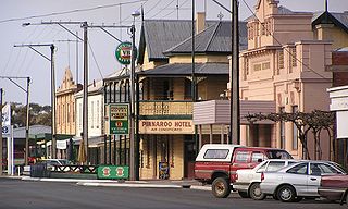
Pinnaroo is a town in the Murray Mallee region of South Australia, near the border with Victoria, 243 km east of Adelaide. Pinnaroo is on the north side of the Mallee Highway, and on the railway line between Tailem Bend and Ouyen. The roadhouse on the highway at Pinnaroo is the first "food and leg-stretch" stop on the bus route from Adelaide to Sydney. At the 2016 census, the locality of Pinnaroo had a population of 712 of which 547 lived in and around its town centre.
Parilla is a town and a locality in the Australian state of South Australia located in the state's Murray Mallee region about 192 kilometres (119 mi) east of the state capital of Adelaide, about 32 kilometres (20 mi) west of the municipal seat of Pinnaroo and about 14 kilometres (8.7 mi) east of the town of Lameroo.
Lameroo is a town in the Murray Mallee region of South Australia. It is on the Mallee Highway and Pinnaroo railway line about 40 km west of the Victorian border, or 210 km east of Adelaide. It is primarily a service town for the surrounding rural areas, growing grain and sheep. Lameroo now includes the former settlements of Kulkami, Mulpata, Wirha and Gurrai, which were on the Peebinga railway line, and Wilkawatt, which was between Parrakie and Lameroo on the Pinnaroo railway.
Jabuk is a locality in the Australian state of South Australia located about 142 kilometres (88 mi) south-east of the state capital of Adelaide and respectively about 78 kilometres (48 mi) west and 58 kilometres (36 mi) east of the municipal seats of Pinnaroo and Tailem Bend.
Mindarie is a small town in the Murray Mallee of South Australia between Karoonda and Loxton. The town was gazetted in 1912. The name Mindarie is believed to originate from the Dieri Aboriginal language, and possibly means "festival to invoke peace".
Marama is a town and a locality in the Australian state of South Australia located in the state's south-east about 146 kilometres (91 mi) east of the state capital of Adelaide and about 28 kilometres (17 mi) east of the municipal seat of Karoonda.

Peake is a town and locality in the Australian state of South Australia situated along the Mallee Highway (B12), approximately 150 kilometres (93 mi) east of the state capital of Adelaide.
Wynarka is a very small town in South Australia 120 kilometres (75 mi) southeast of Adelaide on the Karoonda Highway (B55) and Loxton railway line in the Murray Mallee. Wynarka lies within the District Council of Karoonda East Murray.
Borrika is a town and locality in South Australia. It is on the Karoonda Highway 16 kilometres (9.9 mi) east of Karoonda, and was on the Barmera railway line, later known as the Loxton railway line when the end of the main line closed but the Loxton branch remained open until 2015 and has now also closed.
Galga is a settlement in the northern Murray Mallee region of South Australia. The town of Galga was surveyed in 1915 after the Waikerie railway line from Karoonda to Waikerie was opened in 1914. The line was shortened to Galga in 1990, and closed completely in 1994. There is a small bulk grain silo at Galga, but it is no longer regularly used. Galga has an active Country Fire Service brigade with one fire truck.
Perponda is a town and locality in the Australian state of South Australia located about 111 kilometres (69 mi) east of the state capital of Adelaide.
Sandalwood is a town and locality in the Australian state of South Australia located about 139 kilometres (86 mi) east of the state capital of Adelaide.
Maggea is a town and locality in the Murray Mallee region of South Australia. It is on the Stott Highway between Swan Reach and Loxton and was on the former Waikerie railway line. The town is almost deserted now that the railway line has closed.

Ngarkat is a locality in the Australian state of South Australia located in the south-east of the state at the border with the state of Victoria in both the Murray Mallee and the Limestone Coast regions about 227 kilometres south east of the state capital of Adelaide.
Mantung is a town and a locality in the Australian state of South Australia located in the state's south-east about 140 kilometres (87 mi) east of the state capital of Adelaide, and about 58 kilometres (36 mi) north-east and about 48 kilometres (30 mi) south-west respectively of the municipal seats of Karoonda and Loxton.
Bakara is a rural locality in the District Council of Karoonda East Murray of the Murray and Mallee region of South Australia which was established on 11 November 1999.
Mercunda is a town and a locality in the Australian state of South Australia located in the state's south-east about 134 kilometres (83 mi) east of the state capital of Adelaide, and about 52 kilometres (32 mi) north-east and about 53 kilometres (33 mi) south-west respectively of the municipal seats of Karoonda and Loxton.
Kringin is a town and a locality in the Australian state of South Australia located in the state’s east about 199 kilometres (124 mi) east of the state capital of Adelaide and about 61 kilometres (38 mi) south of the municipal seat of Loxton.
Karte is a town and a locality in the Australian state of South Australia located in the state’s east about 192 kilometres (119 mi) east of the state capital of Adelaide, about 30 kilometres (19 mi) north-west of the municipal seat of Pinnaroo and about 35 kilometres (22 mi) north-east of the town of Lameroo.
Carcuma is a locality in the Australian state of South Australia located about 150 kilometres (93 mi) south-east of the state capital of Adelaide and about 67 kilometres (42 mi) south-east of the municipal seat in Tailem Bend.

