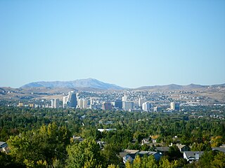
Reno is a city in the northwest section of the U.S. state of Nevada, approximately 22 miles (35 km) from Lake Tahoe, known as "The Biggest Little City in the World". Known for its casino & tourism industry, Reno is the county seat and largest city of Washoe County and sits in a high desert river valley at the foot of the Sierra Nevada and its downtown area occupies a valley informally known as the Truckee Meadows, which due to large-scale investments from Seattle & Bay Area companies such as Amazon, Tesla, Panasonic, Microsoft, Apple and Google has become a new major technology hub in the United States. The city is named after Union Major General Jesse L. Reno, who was killed in action during the American Civil War at the Battle of South Mountain on Fox's Gap.
Washoe County is a county in the U.S. state of Nevada. As of the 2010 census, the population was 421,407, making it Nevada's second-most populous county. Its county seat is Reno.
Spanish Springs is a census-designated place (CDP) in Washoe County, Nevada, United States. It is located in the northeastern part of the Reno–Sparks Metropolitan Statistical Area. The population was 15,064 at the 2010 Census.

Sparks is a city in Washoe County, Nevada, United States. It was founded in 1904, incorporated on March 15, 1905, and is located just east of Reno. The 2010 U.S. Census Bureau population count was 90,264. It is the fifth most populous city in Nevada. It is named after the late Nevada Governor John Sparks, a member of the Silver Party.
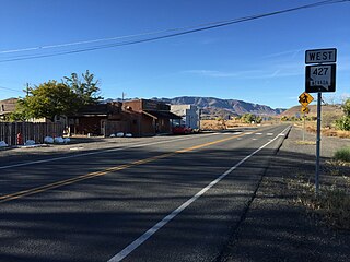
Wadsworth is a census-designated place (CDP) in Washoe County, Nevada, United States. The population was 834 at the 2010 census. It is part of the Reno–Sparks Metropolitan Statistical Area. The town was named for General James S. Wadsworth, a Civil War general killed at the battle of the Wilderness in 1864. It was given this name by Leland Stanford of the Central Pacific Railroad as a favor to General Irvin McDowell, whom Wadsworth had served under during the Civil War.

The Mustang Ranch is a brothel in Storey County, Nevada, about 20 miles (32 km) east of Reno. It is currently located at 1011 Wild Horse Canyon Dr Sparks, NV 89434.
The Virginia Range is a mountain range of western Nevada, primarily within Storey County, and extending east into Lyon County. The range is named after James Finney, "Old Virginny", an early discoverer of gold associated with the Comstock Lode.
The Truckee Meadows is a valley in Northern Nevada, named for the Truckee River, which collects and drains all water in the valley. Truckee Meadows is also colloquially used as a name for the Reno metropolitan area, even though the metro area includes areas outside this valley.
The Wilbur D. May Center is an attraction located in Rancho San Rafael Regional Park at 1595 North Sierra, Reno, Nevada. The facility comprises the Wilbur D. May Museum and the Wilbur D. May Arboretum and Botanical Garden. Previously, it also included the Great Basin Adventure, a children's park.

The Reno-Sparks Indian Colony in Nevada was established in the early 1900s by members of related tribes who lived near Reno for work; they became a federally recognized tribe in 1934 after forming a government under the Indian Reorganization Act.
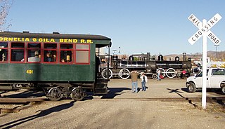
The Nevada State Railroad Museum, located in Carson City, Nevada, preserves the railroad heritage of Nevada, including locomotives and cars of the famous Virginia and Truckee Railroad. Much of the museum equipment was obtained from Hollywood studios, where they were often featured in movies and television. The museum is operated by the Nevada Department of Tourism and Cultural Affairs. Opened in 1980, it was originally named the Virginia & Truckee Railroad Museum, often shortened to V&T Railroad Museum, but was renamed the Nevada State Railroad Museum in 1985.
State Route 443 is a state highway in the Reno-Sparks metropolitan area of Washoe County, Nevada. It is the main connection between the city of Reno and the community of Sun Valley to the north. SR 443 is known as Clear Acre Lane in Reno and Sun Valley Drive within Sun Valley.

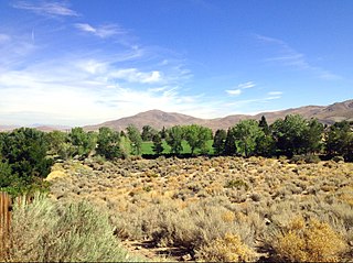
The Washoe Valley is a geographical region in the United States covering 66 square miles (170 km2) in southern Washoe County in the state of Nevada. Located between Reno and Carson City, it is named for the Washoe people, Native Americans who lived there before the arrival of Europeans. Slide Mountain and Mount Rose overlook the valley from the west.
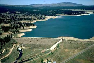
Boca Dam is an earthfill dam and a part of the Truckee Storage Project that encompasses Nevada County, California and Washoe County, Nevada in the United States. Open year-round, it is located at the southern end of Boca Reservoir, 1 mi (2 km) north of Interstate 80, 0.3 mi (480 m) above the confluence of the Little Truckee River and the Truckee River, and 6 mi (9.7 km) northeast of Truckee, California. Reno, Nevada lies 27 mi (43 km) to the east.
State Route 659 is a state highway in Washoe County, Nevada. The route follows McCarran Boulevard, an arterial ring road serving the cities of Reno and Sparks. The route provides access to many businesses and residential areas in the Truckee Meadows.

Eagle Valley is the area encompassing Carson City, Nevada. The valley was first settled during the California Gold Rush of 1849. The discovery of Nevada's Comstock Lode in 1859 established the economic importance of the area, which would become the site of the Nevada State Capitol.
The following is a timeline of the history of the city of Reno, Nevada, United States.

Ophir Creek is a 7.7-mile (12.4 km) eastward-flowing stream originating in Tahoe Meadows just south of Tamarack Peak and southeast of Mount Rose Summit, a pass on Nevada State Highway 431. Ophir Creek flows to Washoe Lake in Washoe County in western Nevada, shortly after passing under U.S. Route 395.

Steamboat Creek drains Washoe Lake, flowing north to northeast through Truckee Meadows and finally intersecting the Truckee River, east of Reno, Nevada. Historical documents indicate that in the early 1860s there were at least six mills reducing Comstock ore in Washoe Valley and during these earliest days of the Comstock mining.
McCarran is an unincorporated community located in northern Storey County and southern Washoe County in the state of Nevada. It lies approximately 11.5 miles (18.5 km) east of Reno on Interstate 80. The community is named for the late U.S. Senator Pat McCarran, a member of the Democratic Party who contributed to the development of aviation both in Las Vegas and on a national scale and was staunchly anti communist.

