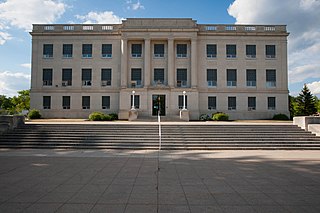
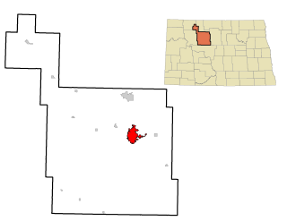
Barnes County is a county in the U.S. state of North Dakota. As of the 2020 United States Census, the population was 10,853. Its county seat is Valley City.

Erskine is a city in Polk County, Minnesota. The population was 503 at the time of the 2010 census. It is part of the Greater Grand Forks region.

Valley City is a city in Barnes County, North Dakota, United States. It is the county seat of Barnes County. The population was 6,585 during the 2010 census, making it the thirteenth largest city in North Dakota. Valley City was founded in 1874.
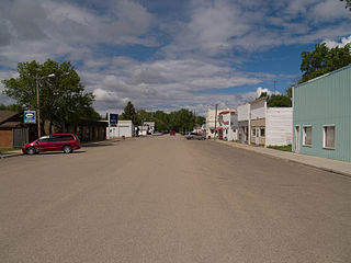
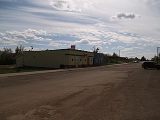
Wimbledon is a city in Pierce Township, Barnes County, North Dakota, United States. The population was 216 at the 2010 census.
Golva is a city in Golden Valley County, North Dakota, United States. The population was 61 at the 2010 census. Golva was founded in 1915.

Grand Forks is the third-largest city in the American state of North Dakota and the county seat of Grand Forks County. According to the 2010 census, the city's population was 52,838, while that of the city and its surrounding metropolitan area was 98,461. Grand Forks, along with its twin city of East Grand Forks, Minnesota, forms the center of the Grand Forks, ND-MN Metropolitan Statistical Area, which is often called Greater Grand Forks or the Grand Cities.
Minot is a city in and the county seat of Ward County, North Dakota, United States, in the state's north-central region. It is most widely known for the Air Force base approximately 15 miles (24 km) north of the city. With a population of 40,888 at the 2010 census, Minot is the state's fourth-largest city and a trading center for a large part of northern North Dakota, southwestern Manitoba, and southeastern Saskatchewan. Founded in 1886 during the construction of James J. Hill's Great Northern Railway, Minot is also known as "Magic City", commemorating its remarkable growth in size over a short time.

Clark is a city in and county seat of Clark County, South Dakota, United States. The population was 1,139 at the 2010 census.
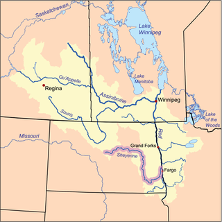
The Sheyenne River is one of the major tributaries of the Red River of the North, meandering 591 miles (951 km) across eastern North Dakota, United States.

Emerson is an unincorporated community recognized as a local urban district in south central Manitoba, Canada, located within the Municipality of Emerson – Franklin. It has a population of 678 as of the 2016 Canada census.

Valley Stream is a station on the Long Island Rail Road's Atlantic Branch serving the residents of Valley Stream, and is the first station in Nassau County. The station is located at Franklin Avenue and Sunrise Highway, west of Rockaway Avenue, and is 16.1 miles (25.9 km) from Penn Station in Midtown Manhattan. The station is wheelchair accessible with an elevator from street level; parking facilities and taxis are available.
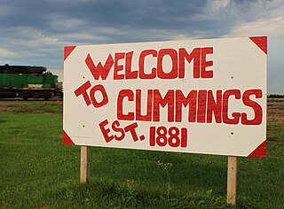
Cummings is an unincorporated community in Traill County, North Dakota, United States.
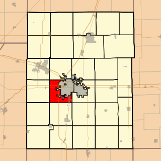
Champaign Township is a township in Champaign County, Illinois, USA. As of the 2010 census, its population was 10,834 and it contained 4,964 housing units.

Johnson Siding is an unincorporated community in Pennington County, South Dakota, United States. The population as of the 2010 census was 659. It is located in the Rimrock Area, approximately 10 miles west of Rapid City. Johnson Siding is surrounded by the Black Hills National Forest. It is the only significant business district in the Rimrock Area, with a gas station/general store, deli, casino, tavern, the Johnson Siding Volunteer Fire Department firehouse, the Rimrock Evangelical Free Church meetinghouse, and a community center. However, most inhabitants work in Rapid City or Deadwood.

Cecil Township is a civil township in Bottineau County in the U.S. state of North Dakota. As of the 2000 census, its population was 28.
The lost towns are a group of places that are still commonly used by county residents. Each was at one time a post office, a store that served a part of the county, a grain elevator used by farmers to ship their crops, or a development that was or may still remain a unique designation. There may be a residential association or some other legal body devoted to the area. More often, these communities are communities of people who still refer to their homes by these geographic designations.
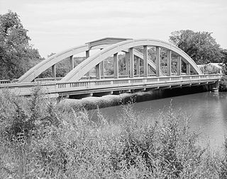
The Rainbow Arch Bridge at Valley City, North Dakota, also known as Main Street Bridge, is a Marsh Rainbow Arch structure that was built in 1925. One year later it was designated as part of an overlap with US 10 and US 52, but was replaced by business routes of both roads and later given the additional overlap of Interstate Business Route 94 which gradually replaced the U.S. business routes. It was listed on the National Register of Historic Places on February 27, 1997, but was demolished and replaced in 2004.
Addie Camp, also known as Kennedyville, Addie Spur, or Canadaville, is a ghost town located in Pennington County, South Dakota, United States. It was a mining camp in the Black Hills.

The Midland Continental Railroad is a defunct shortline railroad which operated in the U.S. state of North Dakota between 1906 and 1966. The railroad was originally envisioned as a trunk line to run from Winnipeg, Manitoba, Canada to Galveston, Texas, on the Gulf of Mexico coast of the United States. Financing problems led to only two segments totalling 77 miles (124 km) being completed.

Freeman is an unincorporated community in Spokane County, Washington, United States. It is notable as being the location of the public elementary, middle and high schools serving a large area of rural southeast Spokane County.

