Oriska, North Dakota

Last updated
Oriska, North Dakota
ND Barnes County Oriska.svg
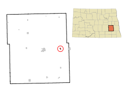
Location of Oriska, North Dakota
USA North Dakota location map.svg
Red pog.svg
Oriska, North Dakota
Usa edcp location map.svg
Red pog.svg
Oriska, North Dakota
Coordinates: 46°55′53″N97°47′21″W / 46.93139°N 97.78917°W / 46.93139; -97.78917
CountryUnited States
State North Dakota
County Barnes
Founded1872
Area
[1]
  Total0.27 sq mi (0.69 km2)
  Land0.27 sq mi (0.69 km2)
  Water0.00 sq mi (0.00 km2)
Elevation
1,270 ft (387 m)
Population
 (2020)
  Total114
  Density426.97/sq mi (164.93/km2)
Time zone UTC-6 (CST)
  Summer (DST) UTC-5 (CDT)
ZIP code
58063
Area code 701
FIPS code 38-59660
GNIS feature ID1030575 [2]

Oriska is a city in Barnes County, North Dakota, United States. The population was 114 at the 2020 census. [3]

Contents

History

Oriska was originally called Fourth Siding, and under the latter name was founded in 1872 when the railroad was extended to that point. [4] The name Oriska was adopted in 1881. [5] Oriska was named for a Native American character in a poem by Lydia Sigourney. [6] A post office called Oriska has been in operation since 1881. [7]

Geography

Oriska is located at 46°55′53″N97°47′21″W / 46.93139°N 97.78917°W / 46.93139; -97.78917 (46.931346, -97.789105). [8]

According to the United States Census Bureau, the city has a total area of 0.28 square miles (0.73 km2), all land. [9]

Demographics

Historical population
CensusPop.Note
1920 300
1930 183−39.0%
1940 21718.6%
1950 135−37.8%
1960 1489.6%
1970 128−13.5%
1980 125−2.3%
1990 103−17.6%
2000 12824.3%
2010 118−7.8%
2020 114−3.4%
2021 (est.)112 [10] −1.8%
U.S. Decennial Census [11]
2020 Census [3]

2010 census

As of the census of 2010, there were 118 people, 48 households, and 32 families living in the city. The population density was 421.4 inhabitants per square mile (162.7/km2). There were 63 housing units at an average density of 225.0 per square mile (86.9/km2). The racial makeup of the city was 94.9% White, 4.2% from other races, and 0.8% from two or more races. Hispanic or Latino of any race were 4.2% of the population.

There were 48 households, of which 31.3% had children under the age of 18 living with them, 58.3% were married couples living together, 6.3% had a female householder with no husband present, 2.1% had a male householder with no wife present, and 33.3% were non-families. 29.2% of all households were made up of individuals, and 4.2% had someone living alone who was 65 years of age or older. The average household size was 2.46 and the average family size was 3.09.

The median age in the city was 41.3 years. 28% of residents were under the age of 18; 3.4% were between the ages of 18 and 24; 24.6% were from 25 to 44; 33.8% were from 45 to 64; and 10.2% were 65 years of age or older. The gender makeup of the city was 57.6% male and 42.4% female.

2000 census

As of the census of 2000, there were 128 people, 47 households, and 31 families living in the city. The population density was 463.4 inhabitants per square mile (178.9/km2). There were 57 housing units at an average density of 206.3 per square mile (79.7/km2). The racial makeup of the city was 98.44% White, and 1.56% from two or more races. Hispanic or Latino of any race were 2.34% of the population.

There were 47 households, out of which 40.4% had children under the age of 18 living with them, 48.9% were married couples living together, 8.5% had a female householder with no husband present, and 34.0% were non-families. 27.7% of all households were made up of individuals, and 8.5% had someone living alone who was 65 years of age or older. The average household size was 2.72 and the average family size was 3.45.

In the city, the population was spread out, with 32.0% under the age of 18, 10.2% from 18 to 24, 30.5% from 25 to 44, 21.1% from 45 to 64, and 6.3% who were 65 years of age or older. The median age was 32 years. For every 100 females, there were 128.6 males. For every 100 females age 18 and over, there were 107.1 males.

The median income for a household in the city was $28,125, and the median income for a family was $26,667. Males had a median income of $18,333 versus $21,250 for females. The per capita income for the city was $10,818. There were 8.3% of families and 14.8% of the population living below the poverty line, including 19.4% of under eighteens and 22.2% of those over 64.
Education

Maple Valley School District operates public schools serving Oriska. [12]

Related Research Articles

<span class="mw-page-title-main">Benton, Kansas</span> City in Butler County, Kansas

Benton is a city in Butler County, Kansas, United States. As of the 2020 census, the population of the city was 943.

<span class="mw-page-title-main">Chickamaw Beach, Minnesota</span> City in Minnesota, United States

Chickamaw Beach is a city in Cass County, Minnesota, United States. The population was 114 at the 2010 census. It is part of the Brainerd Micropolitan Statistical Area.

<span class="mw-page-title-main">Ironton, Minnesota</span> City in Minnesota, United States

Ironton is a city in Crow Wing County, Minnesota, United States. The population was 572 at the 2010 census. It is part of the Brainerd Micropolitan Statistical Area.

<span class="mw-page-title-main">Shelly, Minnesota</span> City in Minnesota, United States

Shelly is a city in Norman County, Minnesota, United States. The population was 179 at the 2020 census.

<span class="mw-page-title-main">Bluffton, Minnesota</span> City in Minnesota, United States

Bluffton is a city in Otter Tail County, Minnesota, United States, along the Leaf River. The population was 210 at the 2020 census.

<span class="mw-page-title-main">Richville, Minnesota</span> City in Minnesota, United States

Richville is a city in Otter Tail County, Minnesota, United States. The population was 77 as of the 2020 census.

<span class="mw-page-title-main">Vining, Minnesota</span> City in Minnesota, United States

Vining is a city in Otter Tail County, Minnesota, United States. The population was 62 at the 2020 census.

<span class="mw-page-title-main">Trail, Minnesota</span> City in Minnesota, United States

Trail is a city in Polk County, Minnesota, United States. It is part of the Grand Forks, ND-MN Metropolitan Statistical Area. The population was 40 at the 2020 census.

<span class="mw-page-title-main">Bella Villa, Missouri</span> City in Missouri, United States

Bella Villa is a city in St. Louis County, Missouri, in the United States. As of the 2010 census, the city population was 729.

<span class="mw-page-title-main">Linwood, Nebraska</span> Village in Nebraska, United States

Linwood is a village in Butler County, Nebraska, United States. The population was 88 at the 2010 census.

<span class="mw-page-title-main">Fingal, North Dakota</span> City in North Dakota, United States

Fingal is a city in Barnes County, North Dakota, United States. The population was 92 at the 2020 census. Fingal was founded in 1891.

<span class="mw-page-title-main">Buffalo, North Dakota</span> City in North Dakota, United States

Buffalo is a city in Cass County, North Dakota, United States. The population was 195 at the 2020 census. Buffalo was founded in 1878.

<span class="mw-page-title-main">Prairie Rose, North Dakota</span> City in North Dakota, United States

Prairie Rose is a city in Cass County, North Dakota, United States. The population was 56 at the 2020 census. The city is an enclave suburb of Fargo. Prairie Rose was founded in 1975. There are 21 homes in the city.

<span class="mw-page-title-main">Niagara, North Dakota</span> City in North Dakota, United States

Niagara is a city in Grand Forks County, North Dakota, United States. It is part of the "Grand Forks, ND-MN Metropolitan Statistical Area" or "Greater Grand Forks". The population was 46 at the 2020 census. Niagara was founded in 1883.

<span class="mw-page-title-main">Fredonia, North Dakota</span> City in North Dakota, United States

Fredonia is a city in Logan County, North Dakota, United States. The population was 38 at the 2020 census. Fredonia was founded in 1905.

<span class="mw-page-title-main">Barney, North Dakota</span> City in North Dakota, United States

Barney is a city in Richland County, North Dakota, United States. The population was 40 at the 2020 census. Barney was founded in 1899. It is part of the Wahpeton, ND–MN Micropolitan Statistical Area.

<span class="mw-page-title-main">Westfield Center, Ohio</span> Village in Ohio, United States

Westfield Center is a village in Medina County, Ohio, United States. The population was 1,115 at the 2010 census. Despite the community's small size, it is the home of Westfield Insurance, the largest employer in Medina County.

<span class="mw-page-title-main">Belle Valley, Ohio</span> Village in Ohio, United States

Belle Valley is a village in Noble County, Ohio, United States. The population was 201 at the 2020 census.

<span class="mw-page-title-main">Milesburg, Pennsylvania</span> Borough in Pennsylvania, United States

Milesburg is a borough in Centre County, Pennsylvania. It is part of the State College, Pennsylvania metropolitan statistical area. The population was 1,093 at the 2020 census.

Onion Creek is a neighborhood in Austin.

References

  1. "ArcGIS REST Services Directory". United States Census Bureau. Retrieved September 20, 2022.
  2. "US Board on Geographic Names". United States Geological Survey. October 25, 2007. Retrieved January 31, 2008.
  3. 1 2 "Explore Census Data". United States Census Bureau . Retrieved July 18, 2022.
  4. Olstad, Geneva Roth (2000). Main Street, North Dakota in Vintage Postcards. Arcadia Publishing. p. 80. ISBN   978-0-7385-0726-2.
  5. North Dakota: Counties, Towns and People. Watchmaker Publishing, Ltd. 2008. p. 16. ISBN   978-1-60386-115-1.
  6. Kelly, Gary (28 August 2008). Lydia Sigourney: Selected Poetry and Prose. Broadview Press. p. 227. ISBN   978-1-77048-047-6.
  7. "Barnes County". Jim Forte Postal History. Retrieved October 22, 2015.
  8. "US Gazetteer files: 2010, 2000, and 1990". United States Census Bureau. February 12, 2011. Retrieved April 23, 2011.
  9. "US Gazetteer files 2010". United States Census Bureau. Archived from the original on January 12, 2012. Retrieved June 14, 2012.
  10. "City and Town Population Totals: 2020-2021". United States Census Bureau. July 18, 2022. Retrieved July 18, 2022.
  11. United States Census Bureau. "Census of Population and Housing" . Retrieved October 31, 2013.
  12. Home. Maple Valley School District. Retrieved on July 17, 2018. "207 Broadway Tower City, ND 58071" and "Serving the communities of Buffalo, Fingal, Oriska and Tower City"