Dazey, North Dakota

Last updated

Dazey, North Dakota
Dazey North Dakota 8-10-2008.jpg
Welcome sign in Dazey
ND Barnes County Dazey.svg
Location of Dazey, North Dakota
Coordinates: 47°11′21″N98°12′8″W / 47.18917°N 98.20222°W / 47.18917; -98.20222
CountryUnited States
State North Dakota
County Barnes
Founded1883
Incorporated as a village1904
Incorporated as a city1967
Government
   Mayor Justin Sherlock
Area
[1]
  Total0.38 sq mi (0.98 km2)
  Land0.38 sq mi (0.98 km2)
  Water0.00 sq mi (0.00 km2)
Elevation
[2]
1,434 ft (437 m)
Population
 (2020) [3]
  Total78
  Estimate 
(2022) [4]
76
  Density205.80/sq mi (79.43/km2)
Time zone UTC-6 (Central (CST))
  Summer (DST) UTC-5 (CDT)
ZIP code
58429
Area code 701
FIPS code 38-18340
GNIS feature ID1028623 [2]

Dazey is a city in Barnes County, North Dakota, United States. The population was 78 at the 2020 census. [3] Dazey was founded in 1883 after a local farmer, Charles Dazey, donated land to start a townsite. [5]

Contents

Geography

According to the United States Census Bureau, the city has a total area of 0.38 square miles (0.98 km2), all land. [6]

History

Dazey was founded in 1883 and named for Charles Turner Dazey, who moved there from Illinois to run a bonanza farm in the early 1880s. Mr. Dazey donated the land to start the townsite. Mr. Dazey later moved back to Illinois where he became a successful playwright. [5] It was incorporated as a village in 1904, and reached a peak population of 293 in 1920. [7] It became a city in 1967, after the North Dakota Legislature enacted legislation that eliminated all existing incorporation titles for towns and villages in the state. [8]

Demographics

Historical population
CensusPop.Note
1910 265
1920 29310.6%
1930 251−14.3%
1940 215−14.3%
1950 196−8.8%
1960 22615.3%
1970 128−43.4%
1980 14311.7%
1990 129−9.8%
2000 91−29.5%
2010 10414.3%
2020 78−25.0%
2022 (est.)76 [4] −2.6%
U.S. Decennial Census [9]
2020 Census [3]

2010 census

As of the census of 2010, there were 104 people, 46 households, and 25 families living in the city. The population density was 273.7 inhabitants per square mile (105.7/km2). There were 56 housing units at an average density of 147.4 per square mile (56.9/km2). The racial makeup of the city was 98.1% White and 1.9% from two or more races. Hispanic or Latino of any race were 1.9% of the population.

There were 46 households, of which 30.4% had children under the age of 18 living with them, 37.0% were married couples living together, 8.7% had a female householder with no husband present, 8.7% had a male householder with no wife present, and 45.7% were non-families. 37.0% of all households were made up of individuals, and 6.5% had someone living alone who was 65 years of age or older. The average household size was 2.26 and the average family size was 3.04.

The median age in the city was 38 years. 26.9% of residents were under the age of 18; 2% were between the ages of 18 and 24; 30.7% were from 25 to 44; 30.8% were from 45 to 64; and 9.6% were 65 years of age or older. The gender makeup of the city was 58.7% male and 41.3% female.

2000 census

As of the census of 2000, there were 91 people, 39 households, and 23 families living in the city. The population density was 238.5 inhabitants per square mile (92.1/km2). There were 47 housing units at an average density of 123.2 per square mile (47.6/km2). The racial makeup of the city was 100.00% White.

There were 39 households, out of which 25.6% had children under the age of 18 living with them, 43.6% were married couples living together, 7.7% had a female householder with no husband present, and 38.5% were non-families. 30.8% of all households were made up of individuals, and 17.9% had someone living alone who was 65 years of age or older. The average household size was 2.33 and the average family size was 2.83.

In the city, the population was spread out, with 25.3% under the age of 18, 2.2% from 18 to 24, 28.6% from 25 to 44, 20.9% from 45 to 64, and 23.1% who were 65 years of age or older. The median age was 42 years. For every 100 females, there were 97.8 males. For every 100 females age 18 and over, there were 106.1 males.

The median income for a household in the city was $22,813, and the median income for a family was $30,000. Males had a median income of $21,875 versus $40,000 for females. The per capita income for the city was $15,056. There were 12.5% of families and 12.5% of the population living below the poverty line, including 14.3% of under eighteens and none of those over 64.

Related Research Articles

<span class="mw-page-title-main">Hettinger, North Dakota</span> City in North Dakota, United States

Hettinger is a city in, and the county seat of, Adams County, North Dakota, United States. The population was 1,074 at the 2020 census.

<span class="mw-page-title-main">Brinsmade, North Dakota</span> City in North Dakota, United States

For people with the surname, see Brinsmade (surname).

<span class="mw-page-title-main">Esmond, North Dakota</span> City in North Dakota, United States

Esmond is a city in Benson County, North Dakota, United States. The population was 91 at the 2020 census. Esmond was founded in 1901.

<span class="mw-page-title-main">Gardena, North Dakota</span> City in North Dakota, United States

Gardena is a city in Bottineau County, North Dakota, United States. The population was 24 at the 2020 census. Gardena was founded in 1905.

<span class="mw-page-title-main">Landa, North Dakota</span> City in North Dakota, United States

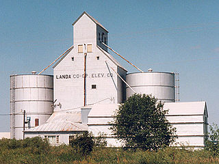
Landa is a city in Bottineau County, North Dakota, United States. The population was 41 at the 2020 census. Landa was founded in 1904.

<span class="mw-page-title-main">Maxbass, North Dakota</span> City in North Dakota, United States

Maxbass is a city in Bottineau County, North Dakota, United States. The population was 89 at the 2020 census. Maxbass was founded in 1905.

<span class="mw-page-title-main">Ayr, North Dakota</span> City in North Dakota, United States

Ayr is a city in Cass County, North Dakota, United States. The population was 11 at the 2020 census. Ayr was founded in 1883.

<span class="mw-page-title-main">Briarwood, North Dakota</span> City in North Dakota, United States

Briarwood is a city in Cass County, North Dakota, United States. The population was 57 at the 2020 census. Briarwood was founded in 1973. It is a suburb directly adjacent to the city of Fargo.

<span class="mw-page-title-main">Sentinel Butte, North Dakota</span> City in North Dakota, United States

Sentinel Butte is a city in Golden Valley County, North Dakota, United States. The population was 61 at the 2020 census.

<span class="mw-page-title-main">Thompson, North Dakota</span> City in North Dakota, United States

Thompson is a city in Grand Forks County, North Dakota, United States. It is part of the "Grand Forks, ND-MN Metropolitan Statistical Area" or "Greater Grand Forks". It is located on the border of Allendale and Walle townships, with Walle on the east and Allendale on the west. The population was 1,101 at the 2020 census. Thompson was founded in 1881.

<span class="mw-page-title-main">Hampden, North Dakota</span> City in North Dakota, United States

Hampden is a tiny city in Ramsey County, North Dakota, United States, which was founded in 1903. The population was 29 at the 2020 census.

<span class="mw-page-title-main">Starkweather, North Dakota</span> City in North Dakota, United States

Starkweather is a city in Ramsey County, North Dakota, United States. The population was 100 at the 2020 census. Starkweather was founded in 1902.

<span class="mw-page-title-main">Adams, North Dakota</span> City in North Dakota, United States

Adams is a city in Walsh County, North Dakota, United States. The population was 127 at the 2020 census. Adams was founded in 1905.

<span class="mw-page-title-main">Ardoch, North Dakota</span> City in North Dakota, United States

Ardoch is a city in Walsh County, North Dakota, United States. The population was 31 at the 2020 census. Ardoch, named for the community of Ardoch, Ontario, was founded in 1881.

<span class="mw-page-title-main">Forest River, North Dakota</span> City in North Dakota, United States

Forest River is a city in Walsh County, North Dakota, United States. The population was 109 at the 2020 census. Forest River was founded on July 13, 1887.

<span class="mw-page-title-main">Hoople, North Dakota</span> City in North Dakota, United States

Hoople is a city in Walsh County, North Dakota, United States. The population was 247 at the 2020 census. Hoople, named for early settler Alan Hoople, was founded in 1889. Hoople's nickname is "Tatertown."

<span class="mw-page-title-main">Crooks, South Dakota</span> City in South Dakota, United States

Crooks is a city in Minnehaha County, South Dakota, United States and is a suburb of Sioux Falls. The population was 1,362 at the 2020 census. Crooks was named New Hope until 1904. The town's present name honors W. A. Crooks, a local politician.

<span class="mw-page-title-main">Tower City, North Dakota</span> City in North Dakota, United States

Tower City is a city in Barnes and Cass counties in the State of North Dakota. The population was 268 at the 2020 census.

<span class="mw-page-title-main">Grandin, North Dakota</span> City in North Dakota, United States

Grandin is a city in Cass and Traill counties in the State of North Dakota, founded in 1881. The population was 186 at the 2020 census. It is now a bedroom community for the nearby Fargo-Moorhead area.

<span class="mw-page-title-main">Sarles, North Dakota</span> City in North Dakota, United States

Sarles is a city in Cavalier and Towner counties in the State of North Dakota. The population was 16 at the 2020 census. Sarles was founded in 1905 at the end of the Great Northern railway extension north of Munich, called the "Sarles Branch". The town is named for North Dakota Governor Elmore Y. Sarles.

References

  1. "ArcGIS REST Services Directory". United States Census Bureau. Retrieved September 20, 2022.
  2. 1 2 U.S. Geological Survey Geographic Names Information System: Dazey, North Dakota
  3. 1 2 3 "Explore Census Data". United States Census Bureau . Retrieved July 18, 2022.
  4. 1 2 "City and Town Population Totals: 2020-2022". United States Census Bureau. December 6, 2023. Retrieved December 6, 2023.
  5. 1 2 Wick, Douglas A. (1988). North Dakota Place Names. Bismarck, North Dakota: Hedemarken Collectibles. ISBN   0-9620968-0-6. OCLC   191277027.
  6. "US Gazetteer files 2010". United States Census Bureau. Archived from the original on July 2, 2012. Retrieved June 14, 2012.
  7. U.S. Census Bureau (1921). "Number and Distribution of Inhabitants, North Dakota" (PDF). Fourteenth Census of the United States: 1920. Government Printing Office . Retrieved July 20, 2008.
  8. North Dakota Secretary of State (1989). North Dakota Centennial Blue Book. Bismarck, ND: North Dakota Legislative Assembly. pp. 500 & 504.
  9. United States Census Bureau. "Census of Population and Housing" . Retrieved October 31, 2013.